1. Mount Vesuvius: Italy’s Sleeping Giant
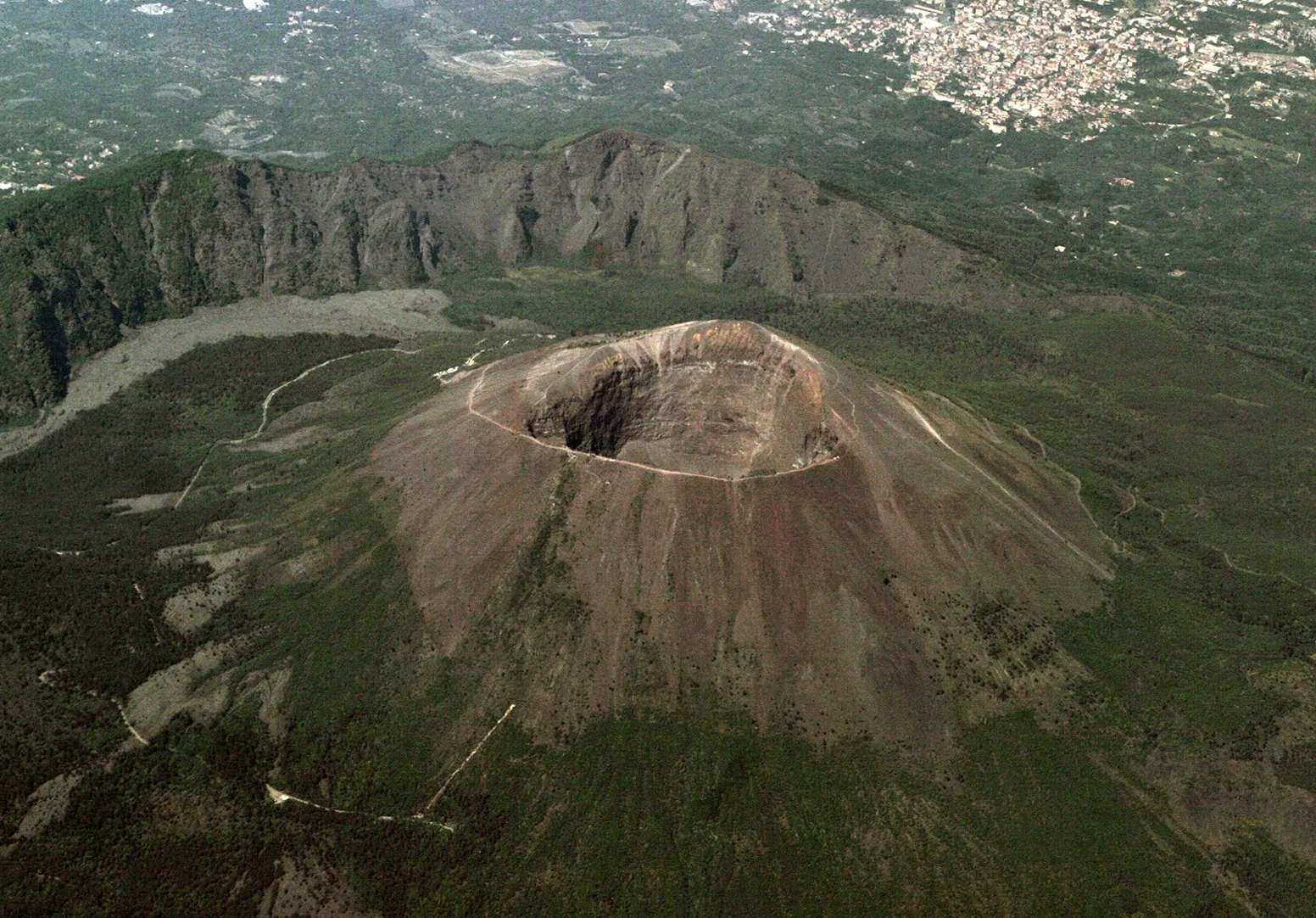
Mount Vesuvius, located in southern Italy near the city of Naples, stands as one of the most infamous and potentially dangerous volcanoes in the world. Its notoriety stems largely from the catastrophic eruption in 79 AD that buried the Roman cities of Pompeii and Herculaneum, preserving them in ash and pumice for nearly two millennia. This eruption, vividly described by Pliny the Younger, has become a defining moment in both geological and historical studies, providing invaluable insights into Roman life and the devastating power of volcanic eruptions. Today, Vesuvius remains an active volcano, silently looming over a densely populated region that is home to over 3 million people. The volcano’s proximity to such a large urban area makes it a subject of intense scientific scrutiny and public concern. Volcanologists continuously monitor Vesuvius for signs of impending activity, employing a wide array of sophisticated technologies including seismographs, gas analyzers, and satellite imagery. This constant vigilance is crucial, as the volcano’s history suggests that future eruptions could pose significant threats to the surrounding communities. The last eruption of Vesuvius occurred in 1944, during World War II, and caused considerable damage to nearby villages. Since then, the volcano has remained relatively quiet, but this period of dormancy is no guarantee of future inactivity. In fact, longer periods of quiescence can sometimes lead to more explosive eruptions when activity resumes. This potential for devastation has led to the implementation of extensive evacuation plans and the establishment of a national park around the volcano to limit further urban development in high-risk areas. Despite the dangers it poses, Mount Vesuvius continues to be a source of fascination for millions of visitors each year. The volcano and its surroundings offer a unique blend of natural beauty, geological wonder, and historical significance. Tourists can hike to the crater’s rim, visit the excavated ruins of Pompeii and Herculaneum, and explore the diverse ecosystems that have developed on the volcano’s fertile slopes. This intersection of tourism, scientific research, and disaster preparedness makes Vesuvius a complex and multifaceted subject, embodying the ongoing challenge of balancing human activity with the unpredictable forces of nature.
2. Mount Rainier: The Sleeping Giant of the Pacific Northwest
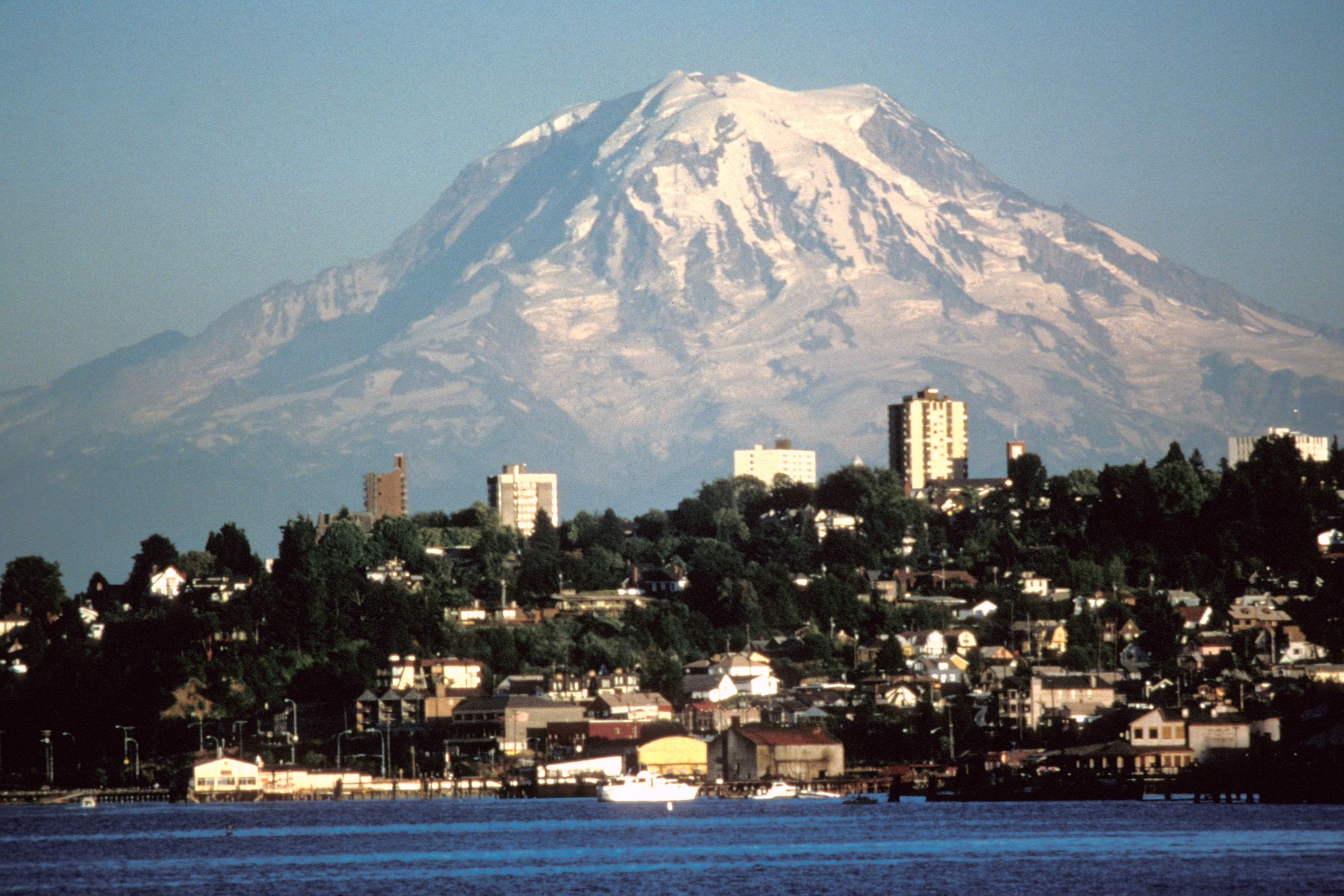
Mount Rainier, an iconic stratovolcano located in Washington State, USA, stands as a majestic sentinel over the Pacific Northwest landscape. Rising to an impressive height of 14,411 feet (4,392 meters) above sea level, it dominates the skyline and serves as a constant reminder of the region’s volcanic heritage. As the highest peak in the Cascade Range and the most glaciated mountain in the contiguous United States, Mount Rainier plays a crucial role in the local ecosystem and climate. Its snow-capped summit and extensive glacier system feed several major river systems, providing water for both wildlife and human communities throughout the region. Despite its serene appearance, Mount Rainier is classified as an active volcano, albeit one that has not erupted in over a century. The last known eruption occurred in the 1890s, but geologists warn that this period of dormancy should not be mistaken for extinction. The volcano’s potential for future activity, combined with its proximity to major population centers like Seattle and Tacoma, makes it a subject of intense scientific study and public concern. The United States Geological Survey (USGS) maintains a network of monitoring stations around the mountain, constantly watching for signs of increased seismic activity, ground deformation, or changes in gas emissions that could indicate an impending eruption. One of the primary concerns regarding Mount Rainier is not just the potential for an explosive eruption, but also the risk of lahars – devastating mudflows caused by the rapid melting of glacial ice during volcanic activity. These lahars could potentially reach populated areas in the valleys below, posing a significant threat to life and property. As a result, extensive hazard mapping and emergency preparedness plans have been developed for the surrounding communities. Despite these potential dangers, Mount Rainier remains a beloved natural landmark and a popular destination for outdoor enthusiasts. The mountain and its surrounding national park offer a wide range of recreational activities, including hiking, climbing, camping, and wildlife viewing. Each year, thousands of climbers attempt to reach the summit, drawn by the challenge and the promise of breathtaking views. The mountain’s diverse ecosystems, ranging from old-growth forests at its base to alpine meadows and barren rocky slopes near its peak, provide habitats for a wide variety of plant and animal species, many of which are unique to the region. This biological diversity, coupled with the mountain’s geological significance, makes Mount Rainier an important site for scientific research across multiple disciplines. As climate change continues to impact the region, researchers are closely monitoring the mountain’s glaciers, which have shown significant retreat in recent decades. These changes not only affect the local hydrology and ecology but also provide valuable insights into global climate trends. Thus, Mount Rainier stands not only as a potential hazard and a recreational paradise but also as a crucial indicator of environmental change in the Pacific Northwest.
3. Mount Fuji: Japan’s Sacred Peak and Cultural Icon
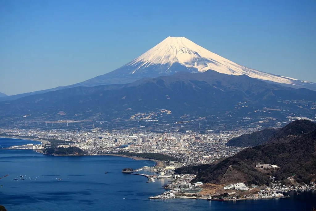
Mount Fuji, Japan’s highest mountain at 12,389 feet (3,776 meters), is an active stratovolcano that has captured the imagination of artists, poets, and pilgrims for centuries. Located on Honshu Island, about 60 miles southwest of Tokyo, Mount Fuji is not just a geological feature but a cultural symbol deeply embedded in the Japanese psyche. Its near-perfect conical shape, often snow-capped, has made it one of the most recognizable natural landmarks in the world and a UNESCO World Heritage Site. The volcano’s last eruption occurred in 1707, but it remains classified as active and is closely monitored by geologists and volcanologists. The Japanese Meteorological Agency maintains a network of sensors around the mountain to detect any signs of increased activity that could presage an eruption. While the risk of an imminent eruption is considered low, the potential impact on the densely populated Kanto region, including Tokyo, necessitates constant vigilance. Mount Fuji’s geological history is complex, with the current edifice being the result of several distinct periods of volcanic activity over hundreds of thousands of years. The mountain is composed of layers of basalt and andesite, with numerous parasitic cones on its flanks. Its distinctive shape is the result of this layered structure combined with erosional processes over time. The volcano’s influence extends far beyond its immediate vicinity, affecting weather patterns and serving as a crucial water source for the surrounding region. The mountain’s cultural significance cannot be overstated. In Shinto religion, Mount Fuji is considered sacred, with shrines dotting its slopes and summit. It has been a site of pilgrimage for centuries, with the practice of climbing the mountain viewed as a spiritual journey. Today, this tradition continues, with hundreds of thousands of people making the ascent each year during the official climbing season from July to September. The mountain has also been a constant source of inspiration for Japanese art and literature. Its image appears in countless ukiyo-e prints, perhaps most famously in Hokusai’s “Thirty-six Views of Mount Fuji.” This artistic legacy has helped to cement Fuji’s place as a national symbol and a source of pride for the Japanese people. In recent years, Mount Fuji has faced increasing environmental pressures due to its popularity as a tourist destination. Concerns about overcrowding, littering, and the impact on fragile alpine ecosystems have led to efforts to balance access with conservation. Authorities have implemented measures such as limiting the number of climbers and promoting responsible tourism practices. Climate change also poses challenges, with rising temperatures affecting snowfall patterns and potentially altering the iconic appearance of the mountain. Despite these challenges, Mount Fuji remains a powerful symbol of Japan’s natural beauty and cultural heritage. It serves as a reminder of the dynamic forces that have shaped the Japanese archipelago and continues to play a vital role in the nation’s identity. As both an active volcano and a beloved landmark, Mount Fuji embodies the complex relationship between human society and the natural world, inspiring awe, respect, and a sense of connection to the earth’s powerful geological processes.
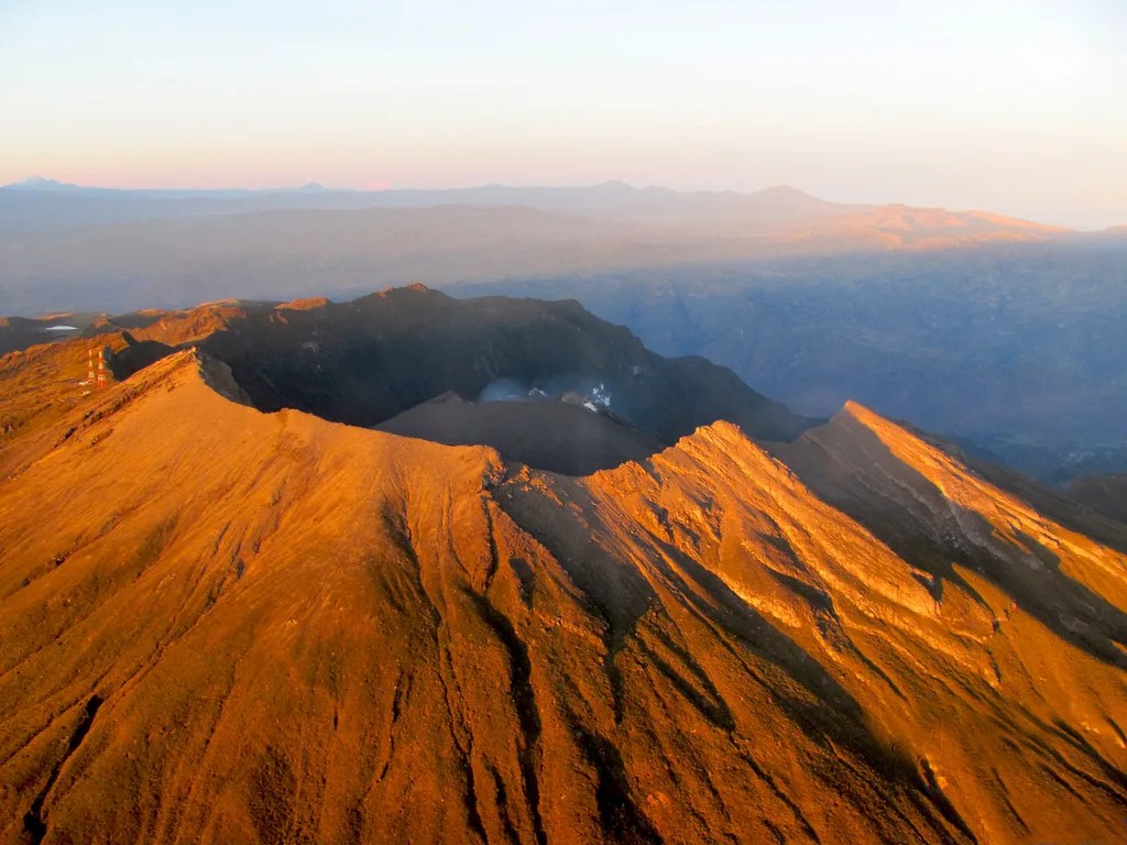
4. Cotopaxi: Ecuador’s Majestic Ice-Capped Volcano
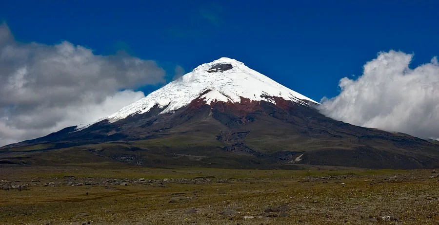
Cotopaxi, one of the world’s highest active volcanoes, stands as a majestic sentinel in the Andes Mountains of Ecuador. Rising to an impressive height of 19,347 feet (5,897 meters) above sea level, its nearly symmetrical cone, capped with a gleaming glacier, creates a breathtaking sight that has captivated both locals and visitors for centuries. Located just 31 miles (50 kilometers) south of Ecuador’s capital city, Quito, Cotopaxi is part of the Pacific Ring of Fire and represents one of the most significant geological features in South America. The volcano’s name, which means “Neck of the Moon” in the indigenous Quechua language, reflects its towering presence and the reverence with which it has been regarded by local cultures throughout history. Cotopaxi’s geological significance extends far beyond its impressive stature. As an active stratovolcano, it has a long history of eruptions, with more than 50 documented events since 1738. The most destructive of these occurred in 1877, when pyroclastic flows melted the mountain’s ice cap, triggering massive lahars (volcanic mudflows) that devastated surrounding valleys and communities. This eruption serves as a stark reminder of the potential dangers posed by the volcano, particularly given its proximity to populated areas. The volcano’s activity is closely monitored by the Geophysical Institute of Ecuador, which maintains a network of seismometers, tiltmeters, and other instruments to detect any signs of impending eruption. This vigilance is crucial, as an eruption of Cotopaxi could have catastrophic consequences for nearby communities and Ecuador’s economy. The volcano’s glaciers pose a particular threat, as their rapid melting during an eruption could lead to devastating lahars capable of reaching Quito and other populated areas. Despite these risks, Cotopaxi National Park, which encompasses the volcano and surrounding area, is a popular destination for tourists and outdoor enthusiasts. The park’s diverse ecosystems, ranging from páramo (high-altitude Andean grasslands) to cloud forests, support a rich variety of flora and fauna, including endangered species like the Andean condor. Mountaineers from around the world are drawn to the challenge of climbing Cotopaxi, although access to the summit is periodically restricted due to volcanic activity. The volcano’s perfect conical shape and stunning glacier make it a favorite subject for photographers and artists, contributing to its status as one of Ecuador’s most recognizable natural landmarks. In recent years, climate change has become an increasing concern for Cotopaxi and other high-altitude tropical glaciers. Rising temperatures have led to significant glacial retreat, which not only alters the volcano’s iconic appearance but also has implications for water resources in the region and potentially for volcanic hazards. Scientists are closely studying these changes to better understand their long-term impacts on the volcano and surrounding ecosystems. As both a natural wonder and a potential hazard, Cotopaxi embodies the complex relationship between human society and the powerful geological forces that shape our planet. It serves as a reminder of the need for continued scientific research, effective hazard mitigation strategies, and a deep respect for the natural world.
5. Teide: The Volcanic Crown of the Canary Islands
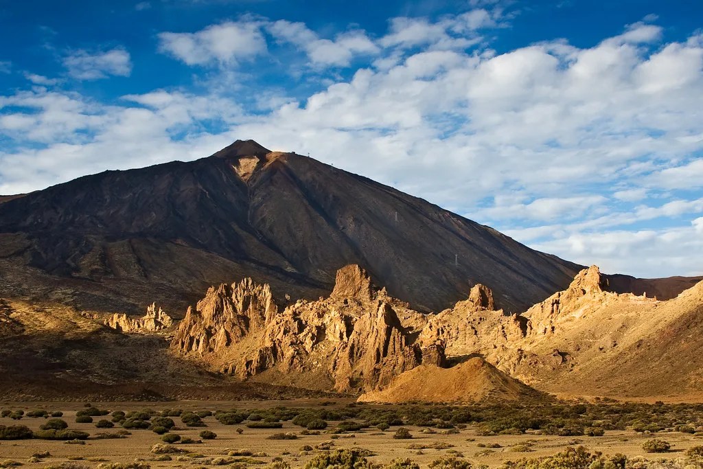
Mount Teide, rising majestically to a height of 12,198 feet (3,718 meters) above sea level, stands as the highest peak in Spain and the centerpiece of Tenerife, the largest of the Canary Islands. This imposing stratovolcano, which last erupted in 1909, is not just a geological marvel but also a UNESCO World Heritage Site and one of the most visited natural wonders in the world. Teide’s significance extends far beyond its impressive stature, encompassing rich geological, ecological, and cultural dimensions that make it a subject of fascination for scientists, tourists, and locals alike. The volcano’s formation is intrinsically linked to the geological history of the Canary Islands, which emerged from the Atlantic Ocean floor through a series of volcanic eruptions over millions of years. Teide itself sits within a massive caldera, the remnant of an even larger ancient volcano that collapsed some 170,000 years ago. This collapse created the Las Cañadas caldera, a vast semicircular depression that now serves as a unique geological laboratory, offering insights into volcanic processes and the Earth’s history. The volcano’s diverse landscapes, ranging from barren lava fields to lush forests, support a remarkable array of endemic plant and animal species, many of which have evolved in isolation on the island. This biological diversity, coupled with the stark beauty of the volcanic terrain, has made Teide National Park a major draw for ecotourism and scientific research. The park’s unique environment, characterized by its high altitude and clear skies, has also made it an ideal location for astronomical observations, hosting several important telescopes and research facilities. Despite its current quiescence, Teide remains an active volcano, closely monitored by the Volcanological Institute of the Canary Islands (INVOLCAN) for any signs of renewed activity. The volcano’s potential for eruption, while not imminent, is a constant consideration in the island’s emergency planning and risk assessment strategies. The last significant seismic activity occurred in 2004, serving as a reminder of the dynamic nature of this seemingly tranquil giant. Teide’s cultural significance cannot be overstated. For the indigenous Guanche people, who inhabited the Canary Islands before European colonization, the mountain was a sacred site, believed to be the dwelling place of Guayota, their devil figure. This spiritual connection to the volcano has persisted through the centuries, with Teide remaining a powerful symbol in Canarian culture and identity. Today, the volcano plays a crucial role in the islands’ economy, serving as a major tourist attraction and contributing significantly to the local tourism industry. The cable car that ascends nearly to the summit allows visitors to experience breathtaking views of Tenerife and the surrounding ocean, while numerous hiking trails offer opportunities to explore the volcano’s diverse landscapes up close. However, this popularity also brings challenges, particularly in terms of environmental conservation and sustainable tourism practices. Efforts are ongoing to balance the economic benefits of tourism with the need to protect Teide’s unique ecosystems and geological features. Climate change poses another significant challenge for Teide and its surrounding ecosystems. Rising temperatures and changing precipitation patterns could alter the delicate balance of life on the volcano, potentially affecting endemic species and the overall biodiversity of the national park. Researchers are closely monitoring these changes, using Teide as a natural laboratory to study the impacts of global climate change on island ecosystems. As both a natural wonder and a potential hazard, Mount Teide embodies the complex interplay between geological forces, ecological systems, and human society. Its ongoing study and conservation are crucial not only for understanding volcanic processes and protecting unique biodiversity but also for preserving a landscape that holds deep cultural and economic significance for the Canary Islands and beyond.
6. Mount St. Helens: A Testament to Nature’s Power and Resilience
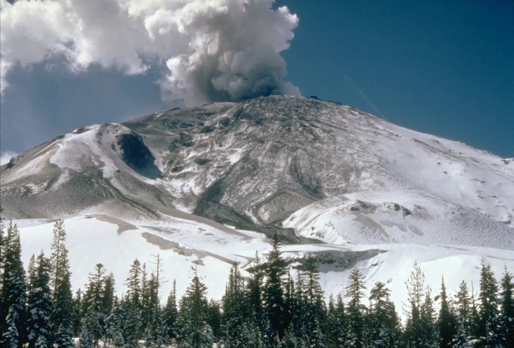
Mount St. Helens, located in Washington State, USA, stands as one of the most infamous and well-studied volcanoes in the world, primarily due to its catastrophic eruption on May 18, 1980. This event, which dramatically altered the volcano’s appearance and the surrounding landscape, has become a benchmark in volcanology and a powerful reminder of the raw force of nature. Rising to a current height of 8,363 feet (2,549 meters), down from 9,677 feet (2,950 meters) before the 1980 eruption, Mount St. Helens continues to be an active volcano and a focal point for scientific research, ecological study, and public fascination. The 1980 eruption of Mount St. Helens was a watershed moment in the study of volcanoes. The lateral blast, triggered by a massive landslide, devastated an area of about 230 square miles (596 square kilometers), leveling forests, melting glaciers, and creating a moonscape of ash and debris. This event, which claimed 57 lives, became the most destructive volcanic event in U.S. history. The eruption provided scientists with unprecedented opportunities to study volcanic processes and their impacts on the environment. In the decades since, Mount St. Helens has become one of the most closely monitored volcanoes in the world, equipped with an array of instruments that track seismic activity, ground deformation, gas emissions, and other indicators of volcanic unrest. This monitoring network not only helps in predicting future eruptions but also contributes to our broader understanding of volcanic systems worldwide. The ecological recovery of the area surrounding Mount St. Helens has been a subject of intense scientific interest. The devastated landscape has served as a natural laboratory for studying ecosystem recovery and succession. Contrary to initial expectations, life began returning to the area almost immediately after the eruption. Plants and animals have gradually recolonized the blast zone, offering valuable insights into the resilience of ecosystems and the processes of ecological recovery following large-scale disturbances. This ongoing transformation has provided scientists with unique opportunities to study long-term ecological changes and has informed conservation and land management practices globally. Mount St. Helens National Volcanic Monument, established in 1982, preserves the volcano and its surroundings for scientific study, education, and recreation. The monument attracts hundreds of thousands of visitors each year, offering a range of interpretive facilities and hiking trails that allow people to witness firsthand the power of volcanic forces and the remarkable recovery of the landscape.Educational programs at the monument play a crucial role in public outreach, fostering an understanding of volcanic hazards and the importance of scientific monitoring. These efforts have helped to increase public awareness of volcanic risks and the need for preparedness in volcanic regions around the world. The volcano’s ongoing activity, including a period of dome-building eruptions from 2004 to 2008, continues to provide valuable data for volcanologists. These more recent events have allowed scientists to refine their models of volcanic behavior and improve their ability to forecast eruptions. The lessons learned from Mount St. Helens have been applied to volcanic monitoring and hazard mitigation efforts globally, potentially saving lives and reducing the impact of volcanic events in other parts of the world. As climate change continues to affect global environments, Mount St. Helens also serves as an important site for studying the impacts of warming temperatures on volcanic landscapes. Researchers are monitoring changes in glacial cover, vegetation patterns, and wildlife distributions, using the volcano as a bellwether for broader environmental shifts in mountainous regions. The legacy of the 1980 eruption and the subsequent recovery of Mount St. Helens continue to shape our understanding of volcanic processes, ecological resilience, and the dynamic nature of Earth’s landscapes. As both a natural wonder and a site of ongoing scientific discovery, Mount St. Helens stands as a powerful reminder of the ever-changing face of our planet and the importance of respecting and studying the forces that shape it.
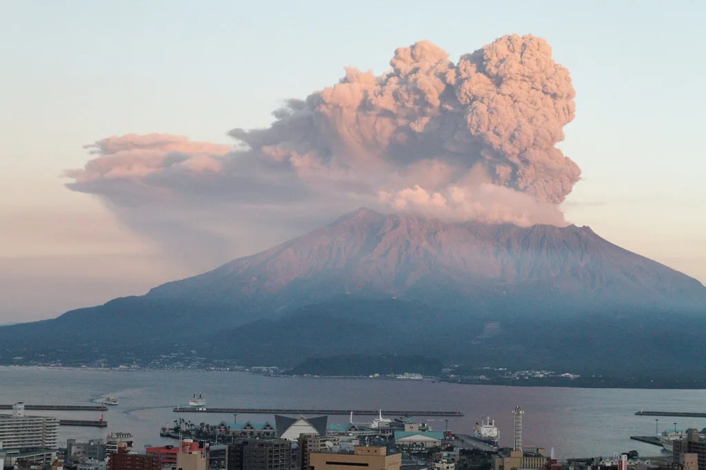
7. Popocatépetl: Mexico’s Smoking Mountain
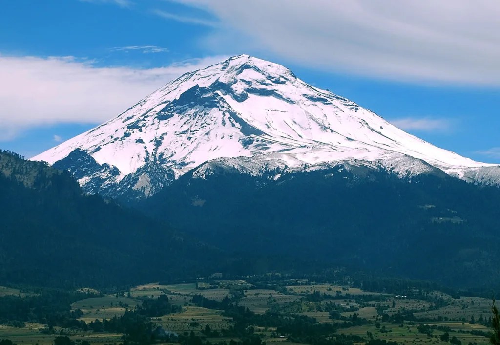
Popocatépetl, whose name means “Smoking Mountain” in the Nahuatl language, is one of Mexico’s most active and iconic volcanoes. Located about 43 miles (70 kilometers) southeast of Mexico City, this massive stratovolcano rises to an impressive height of 17,802 feet (5,426 meters) above sea level. Its proximity to Mexico City and other populous areas makes it a subject of intense monitoring and concern, as any significant eruption could potentially affect millions of people. The volcano has been active for thousands of years, with its history deeply intertwined with the cultures and mythologies of pre-Columbian civilizations. In Aztec mythology, Popocatépetl was a warrior who fell in love with Iztaccíhuatl, a princess. Their tragic love story is said to be reflected in the shapes of Popocatépetl and its neighboring volcano, Iztaccíhuatl. This cultural significance adds an additional layer of importance to the volcano beyond its geological and environmental impact. Popocatépetl’s recent activity has been characterized by frequent small to moderate eruptions, often producing spectacular displays of ash plumes and incandescent material. The volcano entered a new phase of activity in 1994 after decades of relative quiet, and since then, it has been closely monitored by Mexico’s National Center for Disaster Prevention (CENAPRED). A network of seismographs, tiltmeters, and cameras provides real-time data on the volcano’s behavior, allowing scientists to issue timely warnings when activity increases. The persistent activity of Popocatépetl poses significant challenges for nearby communities. Ash falls can disrupt daily life, affecting agriculture, air travel, and public health. The potential for larger eruptions necessitates comprehensive emergency plans, including evacuation procedures for the most at-risk areas. Despite these risks, the fertile volcanic soils around Popocatépetl support extensive agriculture, creating a complex relationship between the volcano and the communities that live in its shadow. Scientific research at Popocatépetl contributes to our broader understanding of volcanic processes and hazard mitigation. Studies of its eruptive history, magma composition, and gas emissions provide valuable insights into the behavior of large stratovolcanoes. This research not only helps in predicting Popocatépetl’s future activity but also informs volcanic hazard assessments worldwide. As climate change affects global weather patterns, researchers are also studying how these changes might influence volcanic activity and associated hazards at Popocatépetl and similar volcanoes. The ongoing activity at Popocatépetl serves as a constant reminder of the dynamic nature of our planet and the need for continued vigilance and research in volcanically active regions. Its majestic presence on the Mexican landscape, combined with its potential for both creation and destruction, makes Popocatépetl a powerful symbol of the forces that shape our world.
8. Colima: The Fire Volcano of Western Mexico
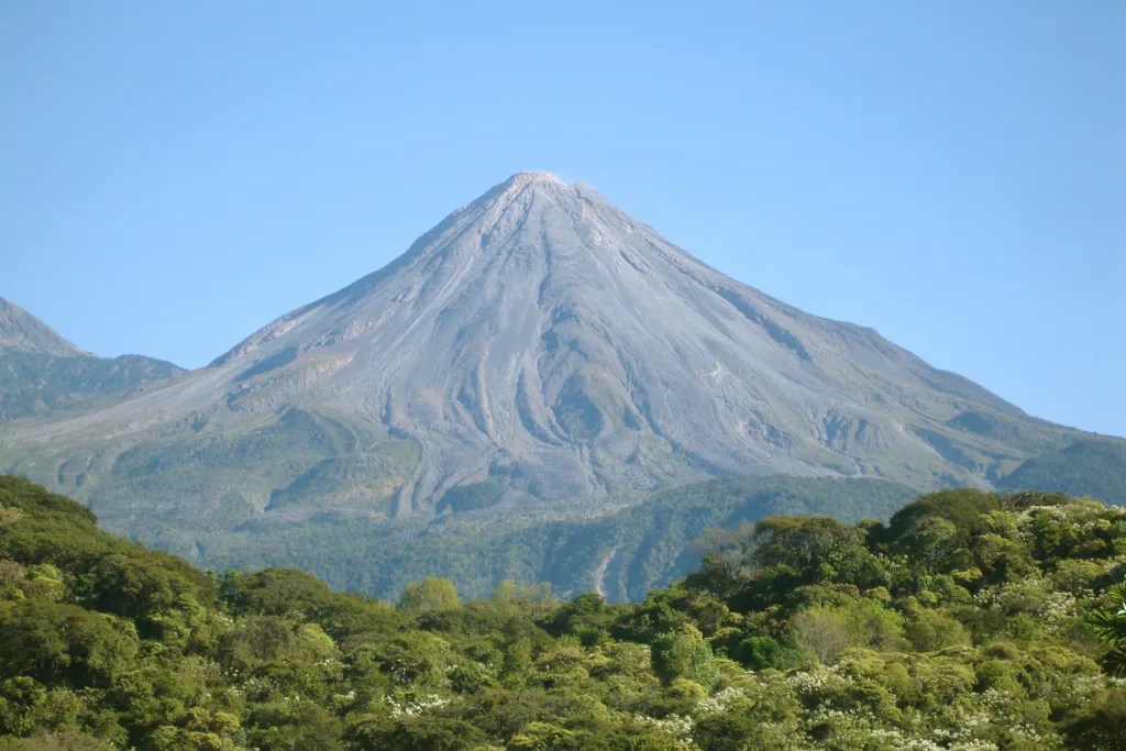
Colima Volcano, also known as Volcán de Fuego (Volcano of Fire), is one of the most active and closely monitored volcanoes in Mexico. Located in the western part of the country, straddling the border between the states of Colima and Jalisco, this stratovolcano has a long history of eruptions that have shaped the surrounding landscape and influenced local cultures for centuries. Rising to an elevation of 12,533 feet (3,820 meters), Colima Volcano is part of a volcanic complex that includes its older and larger neighbor, Nevado de Colima. The active crater of Volcán de Fuego has been the site of frequent eruptions, particularly over the past few decades, making it a focal point for volcanological research and hazard mitigation efforts in Mexico. The volcano’s eruptive activity is characterized by a mix of effusive lava flows, explosive events, and the growth and collapse of lava domes. This variety of volcanic phenomena provides scientists with valuable opportunities to study different aspects of volcanic behavior within a single system. The frequent activity also necessitates constant monitoring and has led to the development of sophisticated early warning systems to protect nearby communities. The Universidad de Colima’s Centro Universitario de Estudios e Investigaciones de Vulcanología (University Center for Volcanological Studies and Research) plays a crucial role in monitoring Colima Volcano. Their work involves a multidisciplinary approach, combining seismic monitoring, gas analysis, thermal imaging, and ground deformation studies to assess the volcano’s state of activity and potential for eruption. This comprehensive monitoring not only helps in predicting eruptions but also contributes to our broader understanding of volcanic processes. The presence of Colima Volcano has significantly influenced the region’s ecology and economy. The fertile volcanic soils support diverse agriculture, including the cultivation of agave plants used in tequila production. However, this agricultural productivity comes with the constant risk of volcanic hazards. Ash falls, lahars (volcanic mudflows), and the potential for larger eruptions pose ongoing challenges for local communities. Balancing the economic benefits of living near the volcano with the need for safety and preparedness is a constant concern for local authorities and residents. Colima Volcano’s frequent activity also makes it an important site for studying the impacts of volcanism on climate and air quality. Researchers analyze the volcano’s gas and ash emissions to better understand their effects on local and regional atmospheric conditions. This research has broader implications for assessing the global impact of volcanic eruptions on climate patterns. The volcano’s dramatic appearance and frequent activity have made it a draw for adventure tourists and researchers alike. However, access to the volcano is carefully regulated due to safety concerns. When conditions allow, guided tours provide visitors with a unique opportunity to witness volcanic processes firsthand, fostering a greater appreciation for the power of nature and the importance of earth sciences. As climate change continues to affect global weather patterns, scientists are also studying how these changes might influence volcanic activity at Colima and other volcanoes worldwide. Understanding these potential interactions is crucial for long-term hazard assessment and preparedness planning. Colima Volcano stands as a testament to the dynamic nature of our planet, offering both challenges and opportunities for the communities that live in its shadow. Its ongoing activity serves as a constant reminder of the need for vigilance, scientific research, and community preparedness in volcanically active regions. As one of Mexico’s most iconic natural features, Colima Volcano continues to shape the physical and cultural landscape of western Mexico, embodying the complex relationship between humans and the powerful geological forces that shape our world.
9. Galeras: Colombia’s Watchful Guardian
Galeras, an andesitic stratovolcano located in southern Colombia near the border with Ecuador, is one of the most active volcanoes in South America. Standing at 14,029 feet (4,276 meters) above sea level, Galeras looms over the city of Pasto, home to approximately 450,000 people, making it a significant source of concern for local authorities and volcanologists alike. The volcano’s name is derived from the Spanish word for galleys, as its shape was thought to resemble an inverted ship by early Spanish conquistadors.
Galeras has a long history of eruptive activity, with records dating back to the 16th century. However, it gained international attention in 1993 when an unexpected eruption occurred during a scientific expedition to the crater, resulting in the deaths of six volcanologists and three tourists. This tragic event underscored the unpredictable nature of volcanic activity and led to significant improvements in volcano monitoring and risk assessment practices worldwide.
Since then, Galeras has been one of the most closely monitored volcanoes in the world. The Colombian Geological Survey (Servicio Geológico Colombiano) maintains a dedicated Volcanological and Seismological Observatory in Pasto, equipped with state-of-the-art technology to detect even the slightest changes in the volcano’s behavior. This includes a network of seismometers, tiltmeters, gas analyzers, and cameras that provide real-time data on the volcano’s activity.
The frequent activity of Galeras poses significant challenges for the surrounding communities. The city of Pasto and several smaller towns are located within the volcano’s potential impact zone, necessitating comprehensive emergency plans and evacuation procedures. Despite these risks, the fertile volcanic soils in the region support a thriving agricultural industry, creating a complex relationship between the volcano and the local population.
Galeras is part of the Andean Volcanic Belt and its study contributes significantly to our understanding of subduction zone volcanism. The volcano’s frequent but relatively small eruptions provide valuable opportunities for researchers to study magma dynamics, gas emissions, and eruption forecasting techniques. This research not only helps in predicting Galeras’ future activity but also informs volcanic hazard assessments globally.
The volcano and its surrounding area have been designated as the Galeras Flora and Fauna Sanctuary, recognizing the unique ecosystems that have developed on its slopes. This protected area is home to a diverse array of plant and animal species, many of which are endemic to the high-altitude Andean environment. The interplay between volcanic activity and biodiversity in this region offers fascinating opportunities for ecological research.
As climate change continues to affect global weather patterns, scientists are also studying how these changes might influence volcanic activity and associated hazards at Galeras. Understanding these potential interactions is crucial for long-term hazard assessment and preparedness planning in the region.
Galeras remains a powerful symbol of both the natural beauty and the potential dangers of the Andean landscape. Its ongoing activity serves as a constant reminder of the need for continued vigilance, scientific research, and community preparedness in volcanically active regions. As one of Colombia’s most iconic natural features, Galeras continues to shape the physical and cultural landscape of southern Colombia, embodying the complex relationship between humans and the powerful geological forces that shape our world.
10. Nevado del Ruiz: The Volcano That Awakened a Nation
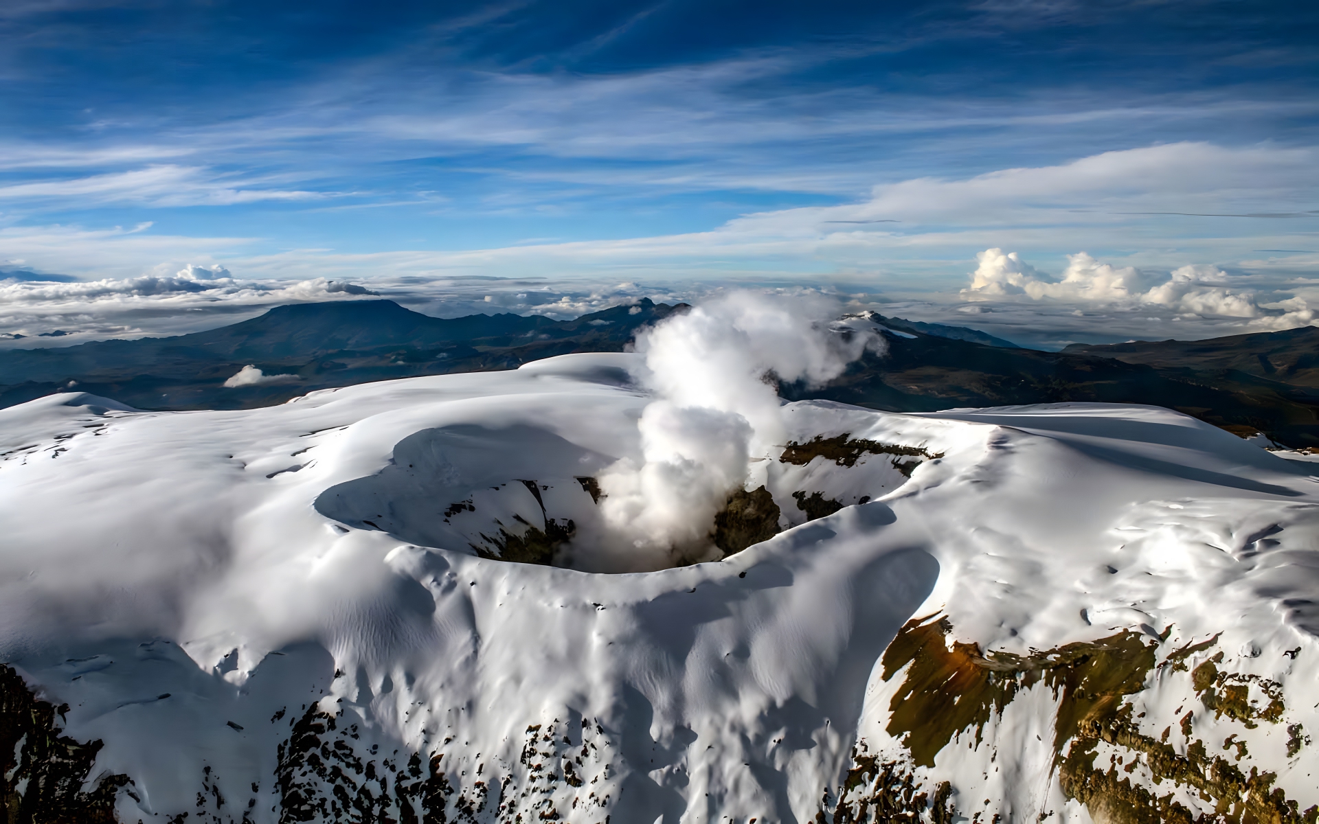
Nevado del Ruiz, a massive stratovolcano located in central Colombia, stands as a somber reminder of the devastating potential of volcanic eruptions. Rising to an elevation of 17,457 feet (5,321 meters), this ice-capped volcano is part of the Andean Volcanic Belt and has played a significant role in shaping both the physical landscape and the approach to volcanic hazard management in Colombia and beyond.
The volcano gained global notoriety on November 13, 1985, when a relatively small eruption triggered catastrophic lahars (volcanic mudflows) that obliterated the town of Armero and caused widespread destruction in the Chinchiná River valley. This disaster, which claimed over 23,000 lives, stands as the deadliest lahar in recorded history and the second-deadliest volcanic disaster of the 20th century. The tragedy of Armero served as a wake-up call for Colombia and the international volcanological community, highlighting the critical importance of effective hazard communication and timely evacuation procedures.
In the aftermath of the 1985 eruption, Colombia significantly enhanced its volcano monitoring capabilities. The Colombian Geological Survey established the Volcanological and Seismological Observatory of Manizales, dedicated to monitoring Nevado del Ruiz and other nearby volcanoes. This facility employs a comprehensive array of monitoring techniques, including seismic networks, gas analyzers, satellite observations, and ground deformation measurements, to detect early signs of volcanic unrest.
The volcano’s glaciated summit adds an additional layer of complexity to hazard assessment and monitoring efforts. The interaction between volcanic heat and the ice cap can lead to rapid melting and the formation of lahars, even during relatively minor eruptive events. Climate change-induced glacial retreat is altering this dynamic, potentially affecting future eruptive behavior and associated hazards.
Nevado del Ruiz remains an active volcano, with periods of increased activity recorded in recent years. Each episode of unrest is closely monitored, and local authorities have developed comprehensive emergency response plans. The lessons learned from the 1985 disaster have led to improved early warning systems and community education programs, aimed at ensuring that local populations are better prepared for potential volcanic emergencies.
Despite its destructive potential, Nevado del Ruiz and its surrounding areas are of great ecological importance. The páramo ecosystem found on its upper slopes is a unique high-altitude environment that plays a crucial role in water regulation for the surrounding regions. The volcano is also part of Los Nevados National Natural Park, which protects a diverse array of Andean flora and fauna.
The study of Nevado del Ruiz continues to contribute significantly to our understanding of volcano-glacier interactions, lahar dynamics, and effective disaster risk reduction strategies. The volcano serves as a natural laboratory for researchers investigating the impacts of climate change on glaciated volcanoes and the potential implications for volcanic hazards.
The legacy of the 1985 Armero tragedy has had far-reaching effects on volcanic risk management globally. It underscored the importance of interdisciplinary approaches to volcano monitoring and the critical need for effective communication between scientists, authorities, and at-risk communities. The disaster also led to increased international cooperation in volcanology and disaster preparedness.
Today, Nevado del Ruiz stands not only as a potential hazard but also as a powerful symbol of resilience and the importance of learning from past tragedies. Its ongoing activity and the efforts to monitor and understand it reflect the complex relationship between human societies and the dynamic forces of our planet. As Colombia continues to develop and refine its approaches to living with active volcanoes, Nevado del Ruiz remains a focal point for scientific research, hazard mitigation efforts, and public education about the power and beauty of Earth’s geological processes.
11. Mount Fuji: Japan’s Sacred Icon
Mount Fuji, or Fujisan in Japanese, is arguably one of the most recognizable and culturally significant volcanoes in the world. Standing at 12,389 feet (3,776 meters), it is Japan’s highest mountain and an active stratovolcano located on Honshu Island, about 60 miles (100 kilometers) southwest of Tokyo. Its near-perfect conical shape, often snow-capped, has made it an enduring symbol of Japan and a source of inspiration for artists, poets, and spiritual seekers for centuries.
Geologically, Mount Fuji is relatively young, having begun to form about 100,000 years ago. It sits at the triple junction where the Amurian Plate, the Okhotsk Plate, and the Philippine Sea Plate meet, contributing to its volcanic nature. The mountain is composed of several distinct layers of lava, ash, and other volcanic deposits, each representing different periods of its eruptive history.
While Mount Fuji is considered an active volcano, its last eruption occurred in 1707-1708, known as the Hoei eruption. This event lasted for 16 days and covered Edo (now Tokyo) in a layer of ash. Despite its current dormancy, the potential for future eruptions remains a concern for Japanese authorities and scientists. The Japan Meteorological Agency closely monitors the volcano for any signs of increased activity, using a network of seismometers, GPS stations, and other advanced technologies.
The cultural and spiritual significance of Mount Fuji cannot be overstated. It has been revered as a sacred mountain in both Shinto and Buddhist traditions for over a millennium. The mountain has numerous shrines and temples around its base and on its slopes, attracting pilgrims and spiritual seekers from across Japan and around the world. In 2013, UNESCO recognized the cultural importance of Mount Fuji by designating it as a World Heritage Site, citing its “sacred place and source of artistic inspiration.”
Mount Fuji plays a crucial role in Japan’s tourism industry, attracting millions of visitors each year. The official climbing season runs from early July to mid-September, during which time thousands of people make the ascent to the summit. The mountain has several routes to the top, catering to climbers of varying abilities. However, the increasing number of climbers has raised concerns about environmental impact and safety, leading to efforts to balance tourism with conservation.
The volcano’s influence extends far beyond its immediate vicinity. Its snowmelt feeds several major river systems and lakes, including the Five Fuji Lakes, which are popular tourist destinations in their own right. The mountain also affects local weather patterns, often creating its own microclimate that can result in unique cloud formations and weather phenomena.
From a scientific perspective, Mount Fuji provides valuable opportunities for research into volcanic processes, plate tectonics, and the geological history of Japan. Studies of its past eruptions and current state contribute to our understanding of volcanic hazards and help inform preparedness strategies for potential future activity.
Climate change is also a concern for Mount Fuji. Researchers have observed changes in the mountain’s snow cover and glacial features, which could have implications for both its iconic appearance and the water resources it provides to surrounding areas. These changes are being closely monitored as part of broader studies on the impacts of global warming on mountainous regions.
The forests surrounding Mount Fuji form an important ecosystem, home to a diverse array of plant and animal species. Conservation efforts aim to protect this biodiversity while managing the pressures of tourism and development in the region. The balance between human activity and environmental preservation remains an ongoing challenge.
In Japanese culture, Mount Fuji continues to be a powerful symbol of national identity, natural beauty, and spiritual significance. It appears frequently in art, literature, and popular culture, both in traditional and contemporary forms. The mountain’s enduring presence in the Japanese consciousness reflects the deep connection between the nation’s people and its natural landscape.
As Japan faces the challenges of the 21st century, including natural disasters, demographic changes, and environmental concerns, Mount Fuji stands as a constant reminder of the country’s resilience, cultural heritage, and the enduring power of nature. Its serene beauty and potential power encapsulate the complex relationship between human society and the natural world, making it not just a national symbol for Japan, but a global icon of the majestic and sometimes unpredictable forces that shape our planet.
12. Santorini, Greece: A Volcanic Paradise with a Cataclysmic Past
Santorini, an enchanting island nestled in the southern Aegean Sea, stands as a testament to the raw power of nature and the resilience of human civilization. This crescent-shaped wonder, born from one of the most catastrophic volcanic eruptions in recorded history, has captivated the hearts and minds of visitors for centuries. The island’s breathtaking scenery, characterized by its iconic white-washed buildings perched atop steep cliffs, is a direct result of its tumultuous geological past. The cataclysmic eruption that occurred around 1600 BC not only reshaped the island’s physical landscape but also potentially contributed to the downfall of the Minoan civilization on nearby Crete. This event, often referred to as the Minoan eruption or the Thera eruption, was so powerful that it is believed to have created tsunamis that reached as far as the eastern Mediterranean coastline. The collapse of the island’s central caldera during this eruption formed the unique semicircular shape that Santorini is famous for today, with the main islands of Thera and Therasia embracing a submerged volcanic crater. Despite the passage of over three millennia, the echoes of this ancient cataclysm continue to resonate through the island’s geology, archaeology, and cultural identity. While Santorini is not currently experiencing significant volcanic activity, the dormant volcano beneath the azure waters of its caldera serves as a constant reminder of the island’s fiery origins. This geological legacy has made Santorini a focal point for scientific research, attracting volcanologists, geologists, and archaeologists from around the world who seek to unravel the mysteries of its past and predict its future behavior. The island’s volcanic history is not merely a subject of academic interest; it has profoundly shaped the daily lives and livelihoods of its inhabitants. The fertile volcanic soil has given rise to unique agricultural products, including the famed Santorini tomatoes and the distinctive Assyrtiko grape variety used in the island’s renowned wines. Furthermore, the dramatic landscape created by the ancient eruption has transformed Santorini into one of the most sought-after tourist destinations in the world, driving a thriving economy based on hospitality and tourism.
13. Mount Nyiragongo, Democratic Republic of the Congo: A Looming Threat in the Heart of Africa
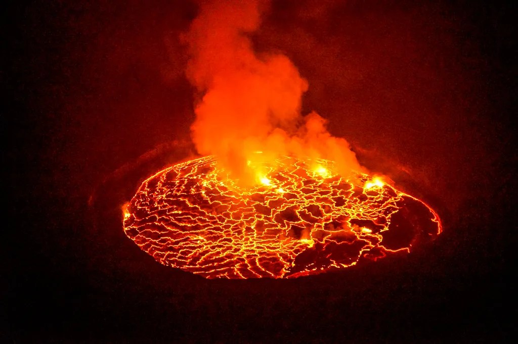
Mount Nyiragongo, towering over the landscape of the Democratic Republic of the Congo, stands as one of the world’s most active and dangerous stratovolcanoes. This formidable peak, located within the boundaries of Virunga National Park, has earned its reputation as a geological marvel and a potential catastrophe waiting to happen. The volcano’s most distinctive and alarming feature is its lava lake, one of the largest and most active in the world. This molten cauldron, which has been active for over a century, contains lava of exceptional fluidity, capable of flowing at speeds of up to 60 miles per hour (100 kilometers per hour) down the volcano’s steep slopes. This characteristic makes Nyiragongo particularly hazardous to the nearby city of Goma and surrounding communities, as demonstrated by its devastating eruptions in 1977 and 2002. The 2002 eruption was especially catastrophic, displacing hundreds of thousands of people and destroying large portions of Goma. The volcano’s location in a region plagued by political instability and conflict adds another layer of complexity to the challenges of monitoring and managing this geological threat. Despite these difficulties, Mount Nyiragongo has become a focal point for scientific research and emergency preparedness efforts. International teams of volcanologists and geologists work tirelessly to study the volcano’s behavior, employing a range of advanced technologies including seismometers, gas analyzers, and satellite imagery. These efforts aim not only to better understand the volcano’s internal dynamics but also to develop more effective early warning systems and evacuation strategies for the vulnerable populations living in its shadow. The unique geological characteristics of Nyiragongo, including its highly fluid lava and the structural instability of its crater walls, present ongoing challenges for prediction and mitigation efforts. The volcano’s eruptions have also had significant ecological impacts on the surrounding Virunga National Park, a UNESCO World Heritage site known for its exceptional biodiversity and as one of the last refuges of the endangered mountain gorilla.
14. Mount Merapi, Indonesia: The Fire Mountain of Java
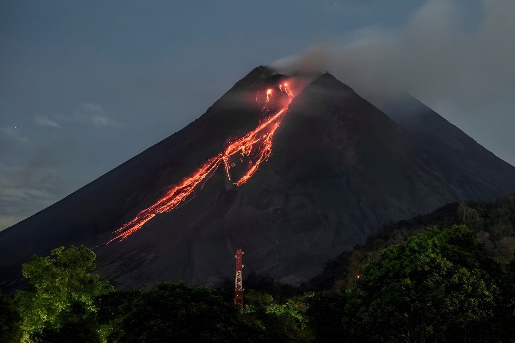
Mount Merapi, whose name aptly translates to “Fire Mountain” in Indonesian, stands as one of the most active and deadly volcanoes in the world. Located on the densely populated island of Java, this imposing stratovolcano has been a constant source of both awe and trepidation for the millions of people living in its vicinity. Merapi’s frequent eruptions, occurring on average every five to seven years, have earned it a reputation as one of Indonesia’s most dangerous volcanoes. The volcano’s location near the cultural center of Yogyakarta, with its population of over 2.4 million people, underscores the critical importance of ongoing monitoring and disaster preparedness efforts. Merapi’s eruptive history is characterized by explosive events that produce pyroclastic flows, lahars, and ash falls, all of which pose significant threats to surrounding communities. The 2010 eruption was particularly devastating, claiming over 350 lives and forcing the evacuation of hundreds of thousands of residents. Despite the dangers, the fertile volcanic soils around Merapi support a thriving agricultural economy, creating a complex relationship between the volcano and the communities that have lived in its shadow for generations. This delicate balance between risk and reward has shaped local culture and traditions, with many Javanese viewing the volcano as a spiritual entity deserving of respect and reverence. The Indonesian government, in collaboration with international scientific organizations, has implemented a comprehensive monitoring system for Mount Merapi. This includes a network of seismometers, tiltmeters, GPS stations, and gas analyzers that provide real-time data on the volcano’s activity. These monitoring efforts are complemented by detailed evacuation plans and community education programs designed to enhance local resilience in the face of volcanic hazards. The study of Mount Merapi has contributed significantly to the field of volcanology, particularly in understanding the behavior of andesitic stratovolcanoes and the dynamics of pyroclastic flows. Ongoing research at Merapi continues to yield valuable insights into volcanic processes and improve hazard assessment methodologies, with implications for volcanic risk management worldwide.
15. Mauna Loa, USA (Hawaii): The Gentle Giant of the Pacific

Mauna Loa, a name that translates to “Long Mountain” in Hawaiian, is a testament to the immense scale and power of Earth’s volcanic processes. As the largest volcano on Earth in terms of volume and area, Mauna Loa dominates the landscape of Hawaii’s Big Island, covering an area of about 2,000 square miles (5,200 square kilometers). This colossal shield volcano is one of the five volcanoes that collectively form the Big Island of Hawaii, rising gradually from the ocean floor to a height of 13,681 feet (4,169 meters) above sea level. When measured from its base on the sea floor to its summit, Mauna Loa stands over 30,000 feet (9,170 meters) tall, making it taller than Mount Everest when compared from base to peak. Despite its massive size, Mauna Loa is known for its relatively gentle slope, a characteristic feature of shield volcanoes formed by highly fluid basaltic lava flows. The volcano’s eruptive history is marked by periods of both intense activity and relative quiescence. While its last eruption occurred in 1984, Mauna Loa remains an active volcano and is closely monitored by the Hawaiian Volcano Observatory. The potential impact of a future eruption on the island’s communities and infrastructure necessitates ongoing vigilance and preparedness. Mauna Loa’s unique geological features, including its vast lava fields, pit craters, and lava tubes, make it an invaluable subject for scientific study. Researchers from around the world come to Mauna Loa to study volcanic processes, lava flow dynamics, and the formation of oceanic islands. The volcano’s summit area, with its harsh, Mars-like environment, has even been used by NASA as a training ground for astronauts and to test equipment destined for Mars missions. Beyond its scientific importance, Mauna Loa holds profound cultural significance for Native Hawaiians, who view the volcano as the physical manifestation of deity and an integral part of their ancestral heritage.
16. Mount Etna, Italy: Europe’s Most Active Volcano
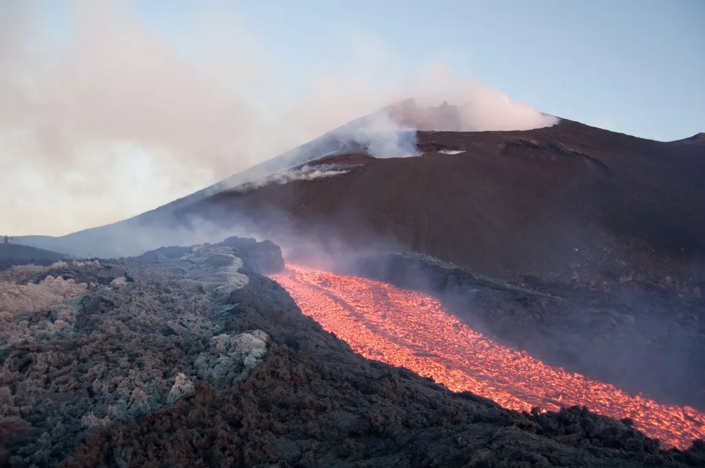
Mount Etna, majestically rising above the eastern coast of Sicily, stands as Europe’s tallest and most active volcano. With a history of eruptions dating back to antiquity, Etna has been a constant presence in the lives of Sicilians for thousands of years, shaping not only the physical landscape but also the cultural and economic fabric of the region. This imposing stratovolcano, reaching a height of approximately 10,922 feet (3,329 meters), is in a near-constant state of activity, with frequent eruptions ranging from mild strombolian explosions to more significant lava flows and ash emissions. Etna’s complex geological structure, comprising multiple summit craters and hundreds of side vents, makes it a fascinating subject for volcanologists and geologists. The volcano’s frequent activity provides researchers with invaluable opportunities to study volcanic processes in real-time, contributing significantly to our understanding of volcanic hazards and eruption dynamics. Despite the potential dangers posed by its eruptions, Mount Etna has played a crucial role in the region’s economy and ecology. The rich volcanic soils surrounding the volcano support extensive agriculture, including the cultivation of vineyards, orchards, and olive groves. The unique mineral composition of these soils imparts distinctive flavors to the local produce, contributing to Sicily’s renowned culinary traditions. Furthermore, Etna’s dramatic landscapes and geological features have made it a popular destination for tourists and outdoor enthusiasts, supporting a thriving tourism industry. In recognition of its exceptional natural and cultural significance, Mount Etna was designated a UNESCO World Heritage Site in 2013. This designation acknowledges not only the volcano’s geological importance but also its role in shaping human history and culture in the Mediterranean region. The ongoing monitoring and scientific research conducted on Mount Etna play a crucial role in mitigating the risks associated with its volcanic activity, helping to protect the surrounding communities and infrastructure. Advanced monitoring techniques, including satellite observations, seismic networks, and gas emission analysis, allow scientists to track changes in the volcano’s behavior and provide early warnings of impending eruptions.