Earth has been shaped by numerous extraterrestrial collisions over its geological history, leaving behind scars in the form of impact craters. These craters serve as tangible evidence of powerful forces from space shaping the planet’s landscape. Each impact event carries a unique story, contributing to our understanding of Earth’s evolution. Here, we explore 10 famous impact craters that have left an indelible mark on the planet, ranging from the catastrophic event linked to the demise of the dinosaurs to ancient collisions that date back billions of years. From the iconic Chicxulub Crater associated with a mass extinction event to the Barringer Crater in Arizona, a stunning testament to the violent nature of celestial encounters, these craters offer a window into Earth’s dynamic history and the relentless cosmic forces that have influenced its course. Join us on a journey to uncover the mysteries behind these geological formations and the profound impact they have had on our planet’s story.
1. Chicxulub Crater (Mexico)
The Chicxulub Crater, located on the Yucatán Peninsula in Mexico, stands as one of the most significant and well-known impact craters on Earth. Its discovery and subsequent research have revolutionized our understanding of mass extinction events and their potential causes. The crater, which measures approximately 180 kilometers (112 miles) in diameter, was formed approximately 66 million years ago when a massive asteroid or comet, estimated to be about 10 to 15 kilometers (6 to 9 miles) wide, collided with Earth.
The impact that created the Chicxulub Crater is widely believed to have been the catalyst for the Cretaceous-Paleogene extinction event, which led to the demise of approximately 75% of plant and animal species on Earth, including most dinosaurs. The collision released an enormous amount of energy, equivalent to billions of atomic bombs, causing widespread devastation across the globe. The impact would have generated massive tsunamis, global wildfires, and ejected a vast amount of debris and aerosols into the atmosphere, leading to a prolonged period of global cooling often referred to as an “impact winter.”
The crater’s discovery in the late 1970s and early 1980s provided crucial evidence supporting the impact theory for dinosaur extinction, which had been proposed by physicist Luis Alvarez and his son, geologist Walter Alvarez, in 1980. The crater’s location, size, and age align perfectly with the geological evidence of the extinction event, including the presence of a global layer of iridium-rich clay at the Cretaceous-Paleogene boundary. Iridium is rare in Earth’s crust but more abundant in asteroids and comets.
Today, the Chicxulub Crater continues to be a subject of intense scientific study. Researchers have conducted deep drilling projects to extract core samples from the crater, providing invaluable insights into the impact’s effects on Earth’s geology and climate. The crater’s structure, which includes a central peak ring, has also helped scientists better understand the mechanics of large impact events and how they shape planetary surfaces.
2. Barringer Crater (Arizona, USA)
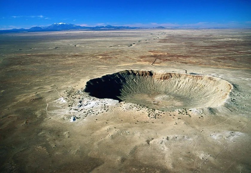
The Barringer Crater, also known as Meteor Crater, is one of the most well-preserved and accessible impact craters on Earth. Located near Winslow, Arizona, in the United States, this impressive geological feature serves as a testament to the immense forces involved in cosmic collisions. The crater was formed approximately 50,000 years ago when an iron-nickel meteorite, estimated to be about 50 meters (160 feet) in diameter, struck the Earth’s surface at a speed of about 12.8 kilometers per second (28,600 mph).
The impact created a bowl-shaped depression measuring about 1,200 meters (3,900 feet) in diameter and 170 meters (560 feet) deep. The force of the collision was so great that it excavated over 175 million metric tons of rock, creating a rim that rises 45 meters (148 feet) above the surrounding plain. The crater’s remarkably preserved state is due to the arid climate of the region, which has minimized erosion over the millennia.
Named after Daniel Barringer, a mining engineer who was the first to suggest its meteoritic origin in 1903, the crater played a crucial role in the development of impact cratering science. Barringer’s hypothesis was initially met with skepticism, as the prevailing theory at the time attributed such crater-like formations to volcanic activity. It wasn’t until the 1960s that Barringer’s impact theory was widely accepted by the scientific community, thanks in part to research conducted at the crater by renowned planetary scientist Eugene Shoemaker.
Today, the Barringer Crater is not only a significant scientific site but also a popular tourist attraction. The crater is privately owned by the Barringer family and is operated as a tourist facility with a museum that educates visitors about impact cratering, meteorites, and planetary science. The site has also been used by NASA for astronaut training, owing to its similarity to lunar craters.
The study of the Barringer Crater has provided valuable insights into impact mechanics and crater formation processes. Its well-preserved features, including the overturned rock layers at the rim and the presence of shocked quartz and other impact-metamorphosed minerals, have helped scientists better understand the extreme conditions created during hypervelocity impacts. This knowledge has been crucial in identifying and studying other impact craters on Earth and other planetary bodies in our solar system.
3. Vredefort Crater (South Africa)
The Vredefort Crater, located in South Africa, holds the distinction of being the largest verified impact structure on Earth. This colossal crater, with an estimated original diameter of about 300 kilometers (190 miles), was formed by a cataclysmic event that occurred approximately 2.02 billion years ago during the Paleoproterozoic Era. The impactor that created this enormous crater is believed to have been an asteroid measuring about 10-15 kilometers (6-9 miles) in diameter, striking the Earth at a velocity of about 20 kilometers per second (12 miles per second).
The immense age and size of the Vredefort Crater make it a unique geological feature and an invaluable source of information about Earth’s distant past. Over the billions of years since its formation, erosion has significantly altered the crater’s appearance, leaving only the central uplift dome and partial ring structures visible today. This central dome, known as the Vredefort Dome, measures about 90 kilometers (56 miles) across and is composed of granite and other ancient rocks that were thrust upward by the impact’s rebound effects.
The Vredefort impact event was so powerful that it likely had global consequences, potentially altering the Earth’s climate and affecting the evolution of life during that period. The energy released by the impact is estimated to have been equivalent to millions of modern nuclear weapons detonating simultaneously. This immense force not only created the crater but also generated intense shock waves that traveled through the Earth’s crust, causing widespread deformation of rocks and minerals.
The crater’s discovery and subsequent research have provided invaluable insights into the Earth’s geological history and the effects of large-scale impact events. Studies of the Vredefort structure have revealed complex patterns of rock deformation, including shatter cones, planar deformation features in quartz, and other shock metamorphic effects that are characteristic of hypervelocity impacts. These features have been crucial in confirming the crater’s impact origin and in developing criteria for identifying other ancient impact structures on Earth.
Today, the Vredefort Dome area is recognized as a UNESCO World Heritage Site due to its geological significance. It continues to be an important location for scientific research, offering geologists and planetary scientists a unique opportunity to study the effects of a massive impact event on Earth’s crust. The site also attracts tourists and geology enthusiasts, who can explore the area’s dramatic landscapes and learn about its extraordinary history through guided tours and educational programs.
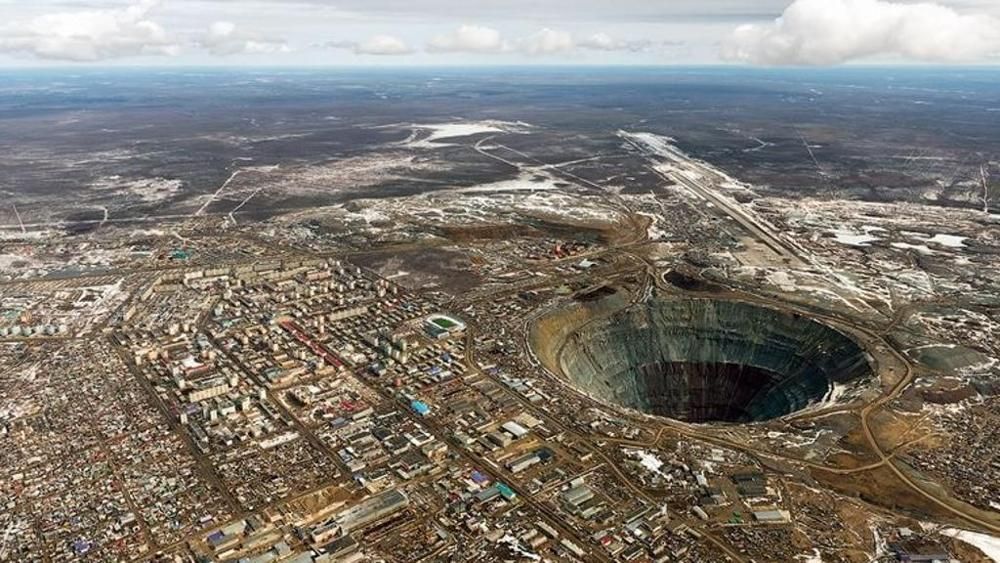
4. Sudbury Basin (Canada)
The Sudbury Basin, located in Ontario, Canada, is one of the largest known impact structures on Earth and a geological wonder that has played a significant role in both scientific research and economic development. Formed approximately 1.85 billion years ago, this elliptical crater measures about 62 kilometers (39 miles) long, 30 kilometers (19 miles) wide, and 15 kilometers (9 miles) deep, making it the second-largest verified impact structure on our planet.
The Sudbury impact event was caused by an asteroid estimated to be about 10-15 kilometers (6-9 miles) in diameter. The collision was so energetic that it not only created the massive crater but also generated an immense amount of heat, melting both the impactor and the target rocks. This melting led to the formation of a large igneous complex known as the Sudbury Igneous Complex (SIC), which is rich in valuable metal ores, particularly nickel, copper, and platinum group elements.
The economic importance of the Sudbury Basin cannot be overstated. The metal-rich deposits formed as a result of the impact have made Sudbury one of the world’s most productive mining regions. Since the discovery of these deposits in the late 19th century, the area has been a major source of nickel and copper, playing a crucial role in Canada’s economy and global metal markets. The unique geological processes triggered by the impact event concentrated these valuable metals, creating ore bodies that have been mined for over a century.
From a scientific perspective, the Sudbury Basin offers an unparalleled opportunity to study large impact structures and their long-term effects on the Earth’s crust. The basin’s age and size make it an important site for understanding the frequency and consequences of major impact events throughout Earth’s history. Research at Sudbury has contributed significantly to our knowledge of impact cratering processes, shock metamorphism, and the formation of large igneous provinces.
The Sudbury area also provides insights into how life on Earth may have recovered and evolved following major impact events. Studies of ancient microfossils found in rocks associated with the impact structure have revealed evidence of microbial life that existed shortly after the cataclysmic event, offering clues about the resilience of life in extreme environments.
Today, the Sudbury Basin continues to be a focus of both scientific research and industrial activity. Its unique geological features, combined with its economic importance, make it a site of great interest for geologists, planetary scientists, and mining companies alike. The area also attracts tourists and educators, who come to learn about its extraordinary history and observe the visible remnants of one of Earth’s most ancient and significant cosmic collisions.
5. Manicouagan Crater (Canada)
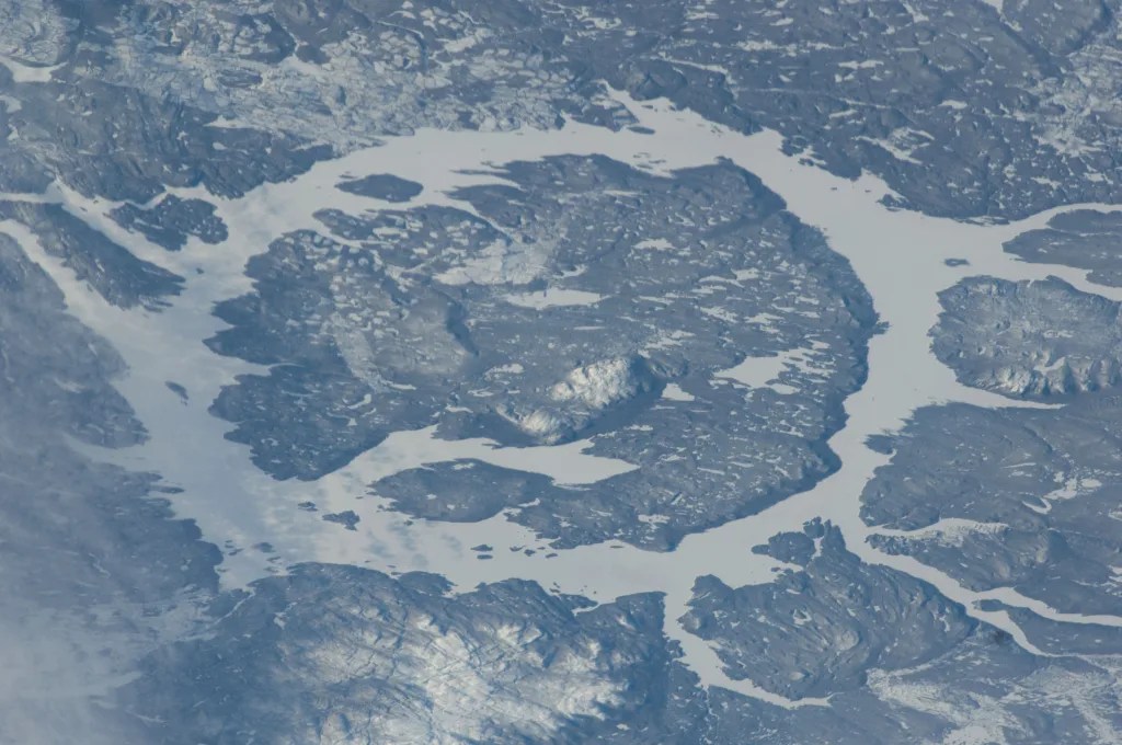
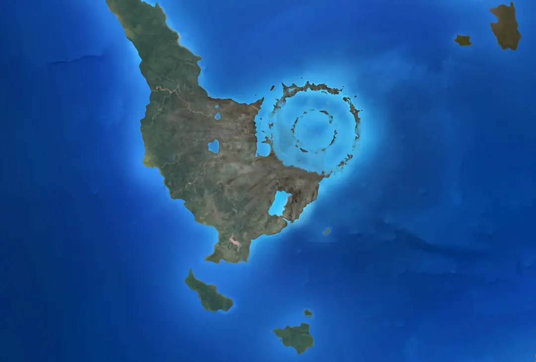
The Manicouagan Crater, located in Quebec, Canada, is one of the most visually striking and scientifically significant impact structures on Earth. Formed approximately 214 million years ago during the Late Triassic period, this crater is a testament to the immense forces involved in cosmic collisions and their long-lasting effects on our planet’s geology. The crater’s most distinctive feature is its ring-shaped lake, known as Lake Manicouagan or the “Eye of Quebec,” which is visible from space and has become an iconic image in impact crater studies.
The Manicouagan impact structure originally measured about 100 kilometers (62 miles) in diameter, although erosion over millions of years has reduced its apparent size. The impactor that created this crater is estimated to have been about 5 kilometers (3 miles) in diameter, striking the Earth with a force equivalent to millions of megatons of TNT. The energy released by this impact would have caused widespread devastation, potentially contributing to a minor extinction event that occurred around the same time.
The crater’s current appearance is the result of millions of years of erosion and glacial activity. The central peak of the crater, typical of large impact structures, has been worn down to form a ring of islands in the center of Lake Manicouagan. The lake itself occupies an annular depression around this central uplift, creating the distinctive eye-like shape when viewed from above. This unique geography has made the Manicouagan Crater an important site for studying the long-term evolution of impact structures on Earth.
From a geological perspective, the Manicouagan Crater offers a wealth of information about impact processes and their effects on the Earth’s crust. The impact melted and deformed the target rocks, creating a variety of shock metamorphic features that are characteristic of hypervelocity impacts. These include shatter cones, planar deformation features in quartz, and pseudotachylite (frictional melt rock). The study of these features has contributed significantly to our understanding of impact cratering mechanics and the extreme conditions created during such events.
The Manicouagan impact event occurred at a crucial time in Earth’s history, near the end of the Triassic period. This timing has led some researchers to investigate whether the impact might have played a role in the Triassic-Jurassic extinction event, although the connection remains a subject of debate. Regardless, the crater provides valuable insights into the potential climatic and environmental effects of large impact events during this period of Earth’s history.
Today, the Manicouagan Crater serves multiple purposes. It remains an important site for scientific research, attracting geologists and planetary scientists who study its unique features. The area is also utilized for hydroelectric power generation, with dams constructed on the rivers flowing into and out of Lake Manicouagan. Additionally, the crater’s striking appearance and scientific significance have made it a point of interest for eco-tourism and educational programs, allowing visitors to witness firsthand the dramatic effects of an ancient cosmic collision.
The preservation and study of the Manicouagan Crater contribute to our broader understanding of impact events and their role in shaping planetary surfaces throughout the solar system. As one of the best-preserved large impact structures on Earth, it continues to provide valuable data for comparative studies with impact craters on other planets and moons, helping scientists reconstruct the impact history of our solar system and better understand the processes that have shaped the surfaces of planetary bodies over billions of years.
6. Popigai Crater (Russia)
The Popigai Crater, located in Siberia, Russia, is one of the largest and most intriguing impact structures on Earth. Formed approximately 35.7 million years ago during the late Eocene epoch, this massive crater measures about 100 kilometers (62 miles) in diameter, making it the fourth largest verified impact structure on our planet. The Popigai impact event was caused by an asteroid estimated to be about 5-8 kilometers (3-5 miles) in diameter, which struck the Earth with devastating force, leaving an indelible mark on the Siberian landscape.
What sets the Popigai Crater apart from many other impact structures is not just its size, but also its unique geological characteristics and potential economic significance. The impact occurred in an area with a complex geological history, including the presence of carbon-rich rocks and ancient crystalline basement rocks. This geological setting, combined with the extreme conditions created by the impact, led to the formation of an extraordinary resource: impact diamonds.
The Popigai impact diamonds, also known as “impact metamorphic diamonds” or “yakutites,” are unlike traditional diamonds formed deep within the Earth. Instead, these diamonds were created instantaneously when the immense heat and pressure of the impact transformed pre-existing graphite in the target rocks into diamond. These impact diamonds are notable for their unusual physical properties, including exceptional hardness and abrasion resistance, which potentially make them valuable for industrial applications.
The discovery of these impact diamonds in the 1970s generated significant interest, with some estimates suggesting that the Popigai Crater could contain trillions of carats of industrial diamonds. However, due to the remote location of the crater and geopolitical factors, large-scale exploitation of this resource has not yet occurred. The potential for diamond mining at Popigai remains a subject of ongoing discussion and research.
From a scientific perspective, the Popigai Crater offers a wealth of information about large impact events and their geological consequences. The crater’s relatively young age and good state of preservation make it an ideal site for studying impact processes and their effects on the Earth’s crust. Researchers have identified a wide range of shock metamorphic features at Popigai, including shatter cones, planar deformation features in quartz, and various types of impact melts and breccias. These features provide crucial data for understanding the mechanics of large impacts and the extreme conditions they create.
The timing of the Popigai impact, near the Eocene-Oligocene boundary, has led some researchers to investigate whether it might have played a role in the climatic cooling trend observed during this period. While the Popigai impact alone was likely not large enough to cause global climate change, it may have contributed to the complex environmental dynamics of the time, potentially interacting with other factors such as changing ocean currents and atmospheric composition.
Today, the Popigai Crater remains a site of significant scientific interest, attracting researchers from various fields including geology, planetary science, and materials science. Its remote location in the Siberian tundra has limited large-scale development or tourism, helping to preserve its unique features for scientific study. The crater and its surroundings also provide valuable insights into the ecology of impact structures, as researchers study how life has recolonized and adapted to this dramatically altered landscape over millions of years.
The Popigai Crater stands as a remarkable testament to the power of cosmic impacts and their ability to shape our planet’s geology, potentially influence its climate, and create unique resources. As research continues, this extraordinary impact structure promises to yield further insights into Earth’s history and the processes that have shaped our planet over millions of years.
7. Chesapeake Bay Impact Crater (USA)
The Chesapeake Bay Impact Crater, located beneath the Chesapeake Bay and surrounding areas on the eastern coast of the United States, is a remarkable hidden geological feature that has significantly influenced the region’s geography and hydrology. Formed approximately 35 million years ago during the late Eocene epoch, this buried impact structure is one of the largest discovered in North America, with an estimated diameter of about 85 kilometers (53 miles).
The crater was created when a bolide, likely an asteroid or comet approximately 3 kilometers (1.9 miles) in diameter, slammed into the shallow continental shelf waters that covered the area at that time. The impact released energy equivalent to many millions of nuclear bombs, instantly vaporizing the impactor and a large volume of target rocks and water. The resulting crater was quickly filled with debris and sediments, concealing it from view and preserving its structure beneath layers of younger deposits.
The discovery of the Chesapeake Bay Impact Crater in the early 1990s was a significant scientific breakthrough. It came about through a combination of geological surveys, deep drilling projects, and the analysis of unusual ground water characteristics in the region. The crater’s existence explained many long-standing geological puzzles in the area, including the presence of saltwater aquifers far inland and the unusual subsidence patterns observed in the Chesapeake Bay region.
One of the most significant aspects of the Chesapeake Bay Impact Crater is its profound and long-lasting effect on the region’s groundwater systems. The impact disrupted and redistributed the pre-existing aquifers, creating a complex hydrogeological environment. The crater fill, composed of a mixture of sediments and fractured rocks, acts as a vast, buried reservoir of briny water. This has important implications for water resource management in the heavily populated coastal areas of Virginia and Maryland, as the salty crater-fill water can contaminate freshwater aquifers.
The crater’s influence extends beyond hydrology to the very shape and evolution of the Chesapeake Bay itself. The impact structure created a long-lasting zone of weakness in the Earth’s crust, which has influenced patterns of erosion and deposition over millions of years. This, in turn, has played a role in shaping the modern Chesapeake Bay, one of the largest and most ecologically important estuaries in North America.
From a scientific perspective, the Chesapeake Bay Impact Crater provides valuable insights into the mechanics of marine impact events and their long-term geological consequences. The crater’s marine target environment at the time of impact resulted in a complex crater structure, including a central peak ring and an extensive breccia lens. Studying these features helps scientists better understand how impacts behave in shallow marine environments, which is crucial for interpreting similar structures on other planets and moons.
The crater also serves as an important case study for the potential climatic effects of large impacts. While not large enough to cause global catastrophic effects, the Chesapeake Bay impact would have had significant regional consequences, potentially influencing local and regional climate patterns for years or even decades after the event.
Today, ongoing research at the Chesapeake Bay Impact Crater continues to yield new insights. Deep drilling projects have recovered core samples from various parts of the crater, allowing scientists to study the impact breccias, shocked minerals, and other features in detail. These studies contribute to our understanding of impact processes, the geological history of the Atlantic coastal plain, and the long-term environmental effects of large impact events.
The hidden nature of the Chesapeake Bay Impact Crater serves as a reminder that Earth’s geological history is full of dramatic events whose traces may not be immediately visible on the surface. As technology and scientific understanding advance, we continue to uncover these hidden scars on our planet, each one telling a story of cosmic collisions and their lasting impacts on Earth’s geology, hydrology, and ecology.
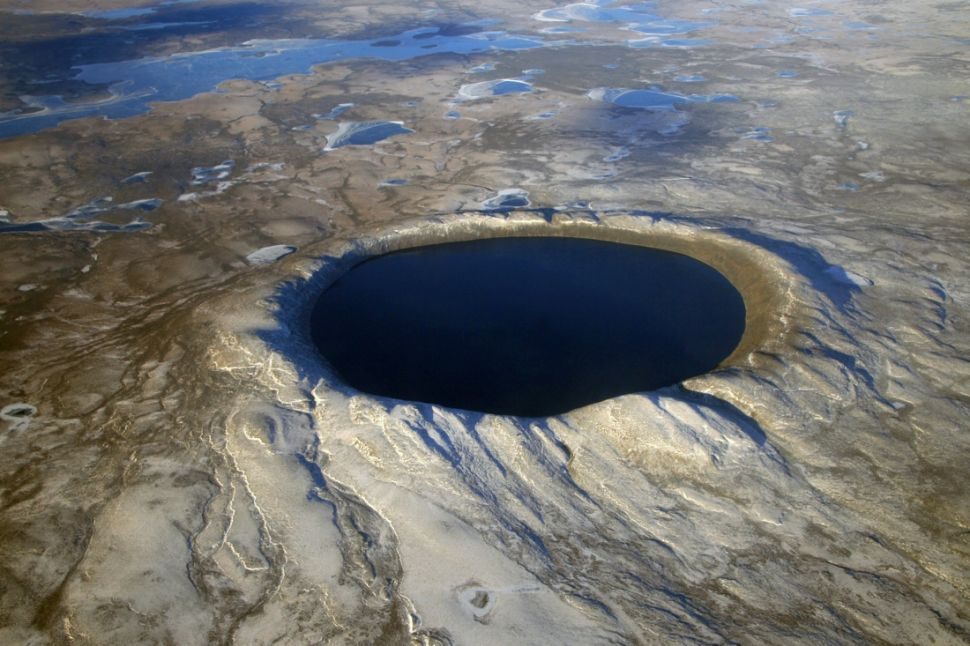
8. Acraman Crater (Australia)
The Acraman Crater, located in South Australia, stands as one of the oldest and most significant impact structures on Earth. Formed approximately 580 million years ago during the Ediacaran period, this ancient crater provides a unique window into Earth’s distant past and the violent cosmic events that have shaped our planet’s surface over eons.
The Acraman impact structure is believed to have originally measured about 90 kilometers (56 miles) in diameter, although erosion over hundreds of millions of years has significantly altered its appearance. Today, the most visible remnant of the crater is Lake Acraman, a salt lake that occupies part of the eroded central uplift of the original crater structure.
What makes the Acraman Crater particularly noteworthy is its age and the geological context in which it formed. The impact occurred during a crucial period in Earth’s history, just before the explosion of complex multicellular life known as the Cambrian explosion. This timing has led researchers to investigate whether the Acraman impact might have played a role in the evolutionary changes observed in the fossil record around this time.
The Acraman impact event was extraordinarily powerful, estimated to have released energy equivalent to millions of megatons of TNT. The force of the impact was so great that it ejected debris over a vast area, creating a distinctive ejecta layer that can be found in rock formations hundreds of kilometers away from the crater site. This ejecta layer, known as the Acraman ejecta horizon, serves as an important stratigraphic marker in Australian geology and has been crucial in dating and studying the impact event.
From a geological perspective, the Acraman Crater offers valuable insights into the processes of impact cratering and the long-term evolution of impact structures on Earth. Despite its great age, the crater still exhibits many characteristic features of impact structures, including shatter cones and shocked quartz grains. These features have been essential in confirming the crater’s impact origin and in developing criteria for identifying other ancient impact structures around the world.
The study of the Acraman Crater and its ejecta has also contributed significantly to our understanding of the potential environmental effects of large impact events. The widespread distribution of ejecta material suggests that the impact would have had substantial regional, and possibly global, consequences. This includes potential short-term climatic effects due to dust and aerosols injected into the atmosphere, as well as longer-term ecological impacts from the redistribution of nutrients and the creation of new habitats in the aftermath of the impact.
Today, the Acraman Crater continues to be an important site for scientific research, attracting geologists, paleontologists, and astrobiologists. Its location in the arid interior of South Australia has helped preserve many of its features, making it a valuable natural laboratory for studying ancient impact processes. The crater and its surrounding area also hold significance for understanding the geological and biological history of the Australian continent during the Precambrian-Cambrian transition.
The Acraman Crater serves as a powerful reminder of the dynamic and often violent nature of Earth’s geological history. It stands as a testament to the massive cosmic impacts that have punctuated our planet’s evolution, potentially influencing the course of life on Earth. As research continues, this ancient impact structure promises to yield further insights into the early Earth, the mechanics of large impacts, and the complex interplay between cosmic events and biological evolution.
9. Haughton Crater (Canada)
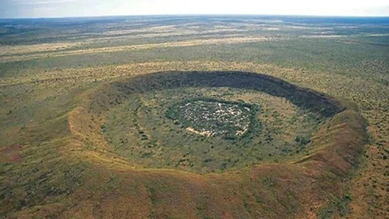
The Haughton Crater, located on Devon Island in the Canadian Arctic Archipelago, is one of the most well-preserved and extensively studied impact structures on Earth. Formed approximately 23 million years ago during the Miocene epoch, this relatively young crater provides scientists with an exceptional opportunity to study the effects of impact events in a pristine Arctic environment.
The Haughton Crater measures about 23 kilometers (14 miles) in diameter and was created by the impact of an asteroid or comet estimated to be about 1-2 kilometers (0.6-1.2 miles) in diameter. The impact occurred in a target area composed of sedimentary rocks overlying older crystalline basement rocks, creating a complex crater structure that has been remarkably well-preserved due to the cold, dry Arctic climate.
One of the most significant aspects of the Haughton Crater is its role as an analog for Martian environments. The crater’s geology, climate, and isolation make it an ideal location for studying processes that might occur on Mars. As a result, the Haughton-Mars Project, an international interdisciplinary field research project, has been conducted at the site since 1997. This project involves simulations of Mars exploration missions, testing of space technologies, and studies of how life might adapt to extreme environments similar to those on Mars.
The geological features of the Haughton Crater provide invaluable insights into impact processes. The crater exhibits a wide range of shock metamorphic effects, including shatter cones, impact melt rocks, and breccias. These features allow scientists to study the extreme conditions created during hypervelocity impacts and how they affect different types of rocks. The crater’s central uplift, although eroded, still preserves evidence of the complex deformation processes that occur during the formation of large impact structures.
From a biological perspective, the Haughton Crater is equally fascinating. The impact event created a unique ecosystem within the crater, including a network of hydrothermal systems that may have persisted for thousands of years after the impact. These hydrothermal systems could have provided habitats for extremophile organisms, making the crater an important site for studying how life might survive in harsh, impact-generated environments on Earth and potentially on other planets.
The crater’s Arctic location also makes it an important site for studying the effects of climate change. As global temperatures rise, the permafrost in and around the crater is thawing, potentially releasing ancient microbial life forms and organic matter that have been frozen for millions of years. This process provides a unique opportunity to study how ecosystems respond to rapid environmental changes and may offer insights into similar processes that could occur on Mars if its polar ice caps were to melt.
The Haughton Crater has also played a crucial role in developing and testing technologies for planetary exploration. Its harsh environment and remote location make it an ideal proving ground for equipment and procedures that might be used in future Mars missions. Researchers have tested rover designs, space suits, drilling equipment, and various scientific instruments in the challenging conditions of the crater.
Today, the Haughton Crater continues to be a hub of scientific activity during the short Arctic summer. Researchers from various fields, including geology, astrobiology, climatology, and space technology, converge on the site to conduct studies and field tests. The crater’s importance extends beyond pure science to space exploration planning, as the lessons learned from research at Haughton directly inform strategies for future missions to Mars and other planetary bodies.
The Haughton Crater stands as a testament to the power of cosmic impacts and their ability to shape planetary surfaces. Its study not only enhances our understanding of impact processes on Earth but also provides crucial insights into the potential for life and the challenges of exploration on other worlds. As research continues, this remarkable Arctic impact structure will undoubtedly continue to yield valuable scientific discoveries and contribute to the advancement of space exploration.
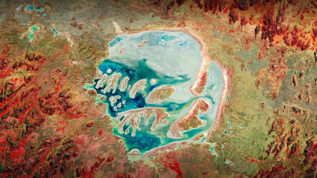
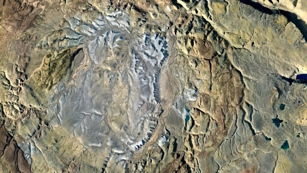
10. Karakul Crater (Tajikistan)
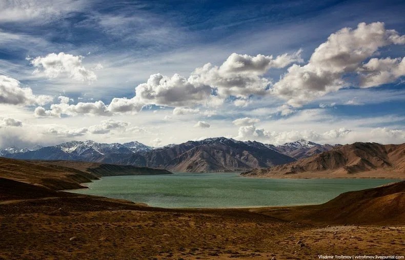
The Karakul Crater, located in the Pamir Mountains of Tajikistan, is a fascinating and relatively understudied impact structure that offers unique insights into the formation and evolution of impact craters in high-altitude, mountainous environments. Formed approximately 25 million years ago during the Oligocene epoch, this crater is notable for its location, preservation state, and the ongoing debate surrounding its origin.
The Karakul Crater is approximately 52 kilometers (32 miles) in diameter and is partially filled by Lake Karakul, a saltwater lake that sits at an elevation of about 3,900 meters (12,800 feet) above sea level. This high-altitude setting makes Karakul one of the highest impact structures on Earth, presenting a unique opportunity to study how impact processes operate in thin atmospheric conditions similar to those on Mars.
The crater’s impact origin has been a subject of scientific debate, with some researchers initially attributing its formation to volcanic or tectonic processes. However, detailed geological studies have revealed evidence supporting an impact origin, including the presence of shocked quartz and other shock metamorphic features. The confirmation of Karakul’s impact origin underscores the importance of thorough geological investigation in identifying ancient impact structures, especially in complex geological settings.
One of the most intriguing aspects of the Karakul Crater is its state of preservation. Despite its considerable age and location in a tectonically active region, many of the crater’s original features remain discernible. This preservation is partly due to the arid climate of the Pamir Mountains, which has limited erosion. The crater’s rim is still visible as a series of hills surrounding Lake Karakul, and the lake itself occupies a depression that likely represents the eroded central portion of the original crater structure.
The geological setting of the Karakul Crater provides valuable insights into how impact events interact with pre-existing geological structures. The crater formed in an area with a complex geological history, including folded and faulted sedimentary and metamorphic rocks. Studying how the impact affected these pre-existing structures helps scientists better understand the mechanics of crater formation in varied geological environments.
From an ecological perspective, Lake Karakul and its surrounding area present a unique high-altitude ecosystem. The lake is one of the largest salt lakes in Central Asia and is home to several endemic species adapted to its harsh environment. The impact event that created the crater basin has thus inadvertently created a habitat that supports a distinct ecological community, demonstrating the long-term biological consequences of cosmic impacts.
The Karakul Crater also holds significance for understanding the climate history of Central Asia. Sediment cores from Lake Karakul provide a record of climate changes over thousands of years, offering insights into past environmental conditions in this high-altitude region. This paleoclimate data is valuable for understanding long-term climate trends and for contextualizing current climate change impacts in Central Asia.
Research at the Karakul Crater faces challenges due to its remote location and the high-altitude environment. However, these same factors make it an excellent analog for studying impact processes and environmental conditions on other planetary bodies, particularly Mars. The thin atmosphere, cold temperatures, and arid conditions at Karakul bear similarities to Martian environments, making it a valuable site for testing theories about crater formation and evolution on the Red Planet.
As scientific interest in the Karakul Crater grows, it promises to yield further insights into impact cratering processes, high-altitude ecosystems, and the geological and climatic history of Central Asia. The crater serves as a reminder of the ongoing discoveries being made in impact crater research and the importance of studying these structures in diverse geological and geographical settings around the world. Through continued research, the Karakul Crater will undoubtedly contribute to our broader understanding of impact events and their long-term effects on planetary surfaces and ecosystems.