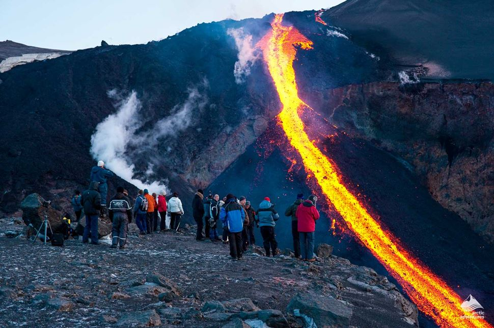
Active volcanoes are natural wonders that continuously shape and reshape our planet’s landscape. These geologic giants, scattered across various regions of the world, exhibit a persistent and ongoing pattern of volcanic activity. This activity can manifest as eruptions, lava flows, ash plumes, and other volcanic phenomena. The world’s most active volcanoes are renowned for their unpredictability and capacity to impact the environment, local communities, and even global climate.
Volcanic eruptions are the result of the movement of molten rock (magma) from beneath the Earth’s crust to the surface. When this magma reaches the surface, it can create spectacular displays of eruptive power, but it also poses potential hazards to those living in proximity. Monitoring and understanding these active volcanoes is crucial for the safety and well-being of communities nearby and for the broader scientific community, as the study of these volcanoes offers insights into Earth’s geologic processes.
In this series, we will delve into the world’s most active volcanoes, exploring their locations, histories, notable eruptions, and their impact on the surrounding regions. We will also discuss the measures in place to monitor and mitigate the risks associated with these volcanoes. From the fiery spectacle of Hawaii’s Kilauea to the snow-capped peaks of Italy’s Mount Etna, join us on a journey to discover the incredible geological forces that shape our planet and the resilient communities that call these volatile landscapes home.
Now we have made a list of the biggest volcanoes that have been active recently.The volcanoes below are considered especially dangerous due to latest eruptions or due to being included in the Decade Volcanoes list. The Decade Volcanoes list is a list of 16 volcanoes worldwide identified by the International Association of Volcanology and Chemistry of the Earth’s Interior (IAVCEI) as being worthy of particular study in light of their history of large, destructive eruptions and proximity to populated areas.
1. Kilauea, Hawaii, USA
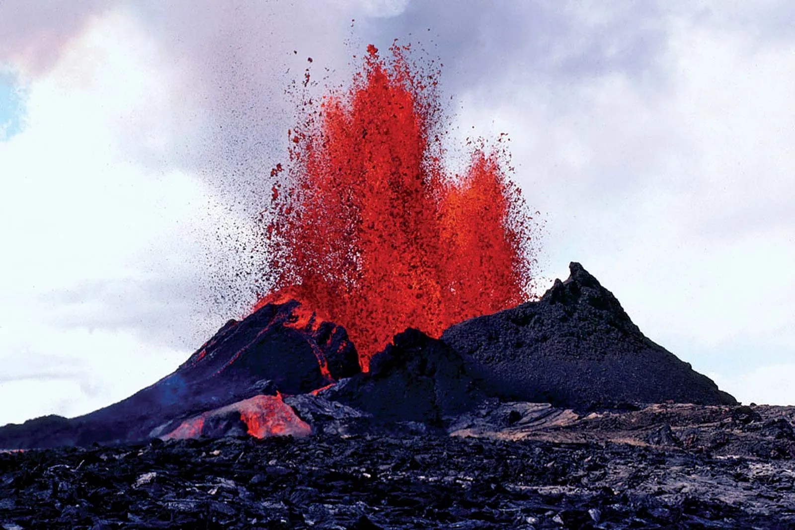
Kilauea, a name that resonates with both awe and reverence among volcanologists and nature enthusiasts alike, stands as a testament to the raw power and beauty of Earth’s geological processes. Situated on the southeastern slope of Mauna Loa on the Big Island of Hawaii, Kilauea is not just any volcano; it is one of the most active volcanoes on our planet, continuously reshaping the landscape of the Hawaiian archipelago. This shield volcano, characterized by its gently sloping profile, has been erupting almost continuously since 1983, making it a focal point for scientific study and a magnet for tourists from around the globe.
The Pu’u ‘Ō’ō eruption, which began in January 1983, is perhaps one of the most significant and longest-lasting eruptions in Kilauea’s recent history. This eruption has profoundly altered the topography of the Big Island, adding new land to its shores and creating a dynamic, ever-changing environment that serves as a living laboratory for geologists. The lava flows from this eruption have covered vast areas, destroying forests, roads, and even entire communities in their path. Yet, from this destruction comes creation, as the cooling lava forms new land, expanding the island’s shoreline and creating unique ecosystems that are found nowhere else on Earth.
One of the most spectacular phenomena associated with Kilauea’s eruptions is the creation of lava ocean entry points. As molten lava flows reach the Pacific Ocean, they create billowing plumes of steam and hydrochloric acid, a hazardous but mesmerizing spectacle. This interaction between lava and seawater not only creates new land but also contributes to the formation of distinctive black sand beaches, a hallmark of Hawaii’s volcanic coastlines. The process of land creation through volcanic activity is a vivid reminder of the ongoing geological processes that have shaped our planet for billions of years.
The Hawaiian Volcano Observatory (HVO), perched on the rim of Kilauea’s caldera, plays a crucial role in monitoring the volcano’s activity. Established in 1912, the HVO employs a wide array of cutting-edge technologies to track seismic activity, ground deformation, gas emissions, and lava flow patterns. This constant vigilance is essential not only for scientific research but also for ensuring the safety of the local population and the millions of visitors who come to witness Kilauea’s majestic power each year. The data collected by the HVO contributes significantly to our understanding of volcanic processes and helps in developing better prediction models for volcanic eruptions worldwide.
Hawaii Volcanoes National Park, which encompasses Kilauea, offers visitors a unique opportunity to witness the raw power of nature up close. The park’s infrastructure, including visitor centers, hiking trails, and viewing platforms, is carefully managed to provide safe access to some of the most dramatic volcanic landscapes on Earth. However, the dynamic nature of Kilauea means that park authorities must remain constantly alert, ready to close areas or evacuate visitors at a moment’s notice if volcanic activity intensifies. This delicate balance between public access and safety underscores the challenges of managing a national park centered around one of the world’s most active volcanoes.
2. Mount Etna, Sicily, Italy
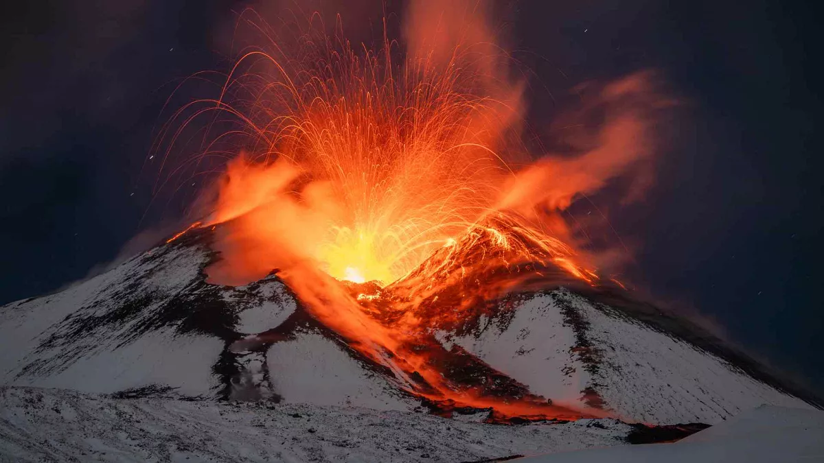
Mount Etna, rising majestically from the eastern coast of Sicily, stands as Europe’s most active and tallest volcano, a towering sentinel that has shaped the history, culture, and landscape of the Mediterranean for millennia. This stratovolcano, with its distinctive conical shape formed by layers of lava, tephra, and volcanic ash, has been a source of wonder, fear, and inspiration since ancient times. Greek mythology associated Etna with the forge of Hephaestus and the prison of the monster Typhon, while modern science sees it as a crucial window into the Earth’s geological processes.
The volcano’s frequent eruptions, sometimes occurring multiple times a year, have made it a focal point for volcanological research and a constant presence in the lives of Sicilians. These eruptions vary widely in intensity and character, ranging from gentle effusive events that produce spectacular lava flows to more explosive episodes that send ash plumes kilometers into the sky. The diversity of Etna’s eruptive styles provides scientists with invaluable opportunities to study different volcanic phenomena, contributing significantly to our understanding of volcanology and Earth sciences.
One of the most remarkable aspects of Mount Etna is its role in shaping the surrounding landscape and ecology. The fertile volcanic soils on its slopes support extensive agriculture, with vineyards, orchards, and olive groves thriving in the mineral-rich earth. This agricultural bounty has been a cornerstone of the local economy for centuries, with Etna’s wines, in particular, gaining international recognition for their unique terroir. However, this proximity of human activity to an active volcano also presents significant challenges, as eruptions and lava flows can threaten crops, infrastructure, and communities.
The monitoring of Mount Etna is a sophisticated operation involving a network of scientific institutions and cutting-edge technology. The Istituto Nazionale di Geofisica e Vulcanologia (INGV) leads these efforts, employing a wide array of instruments including seismometers, GPS stations, gas analyzers, and thermal cameras to track the volcano’s every movement and breath. This constant surveillance allows scientists to detect subtle changes that might precede an eruption, providing crucial early warnings to local authorities and populations. The wealth of data collected from Etna also contributes to global volcanic research, helping to refine models and predictions for volcanic activity worldwide.
Despite the potential dangers it poses, Mount Etna has become a major tourist attraction, drawing hundreds of thousands of visitors each year. The volcano’s UNESCO World Heritage status, granted in 2013, recognizes its exceptional natural value and scientific importance. Visitors can explore the volcano’s lower slopes by car or bus, while guided tours offer the opportunity to ascend higher, witnessing firsthand the dramatic landscapes sculpted by millennia of volcanic activity. Cable cars and off-road vehicles provide access to viewing points near the summit craters, offering breathtaking vistas of the Sicilian coastline and, if conditions permit, glimpses of ongoing volcanic activity.
The relationship between Mount Etna and the communities that live in its shadow is complex and multifaceted. While the volcano’s eruptions can pose significant threats, necessitating evacuations and causing damage to property and infrastructure, many locals view Etna with a mixture of respect and affection, often referring to it as “Mamma Etna.” This cultural connection reflects a deep understanding of the volcano’s dual nature as both a source of danger and a provider of fertile soil and natural beauty. The ongoing dialogue between human civilization and this powerful force of nature continues to shape the identity and destiny of Sicily, serving as a poignant reminder of humanity’s place within the grand tapestry of Earth’s geological processes.
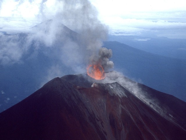
3. Pacaya, Guatemala
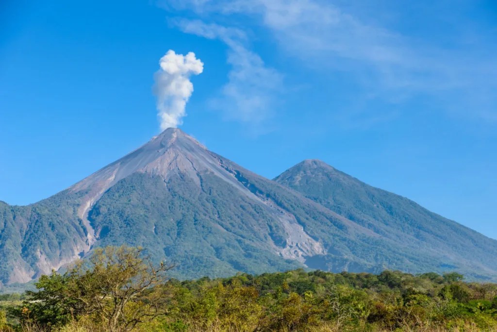
Pacaya, a complex volcano located approximately 30 kilometers south of Guatemala City, stands as one of Central America’s most active and captivating geological features. Rising to an elevation of 2,552 meters (8,373 feet) above sea level, this relatively young volcano has been in a state of near-constant eruption since 1965, making it a focal point for both scientific study and adventurous tourism. Pacaya’s dynamic nature, characterized by frequent Strombolian eruptions, lava flows, and occasional more explosive events, offers a vivid window into the volcanic processes that have shaped much of Guatemala’s dramatic landscape.
The volcano’s recent eruptive history is marked by periods of intense activity interspersed with relative calm. One of the most significant events in Pacaya’s modern history occurred in May 2010, when a powerful eruption sent ash and debris raining down on Guatemala City and surrounding areas, forcing the closure of the international airport and the evacuation of thousands of residents. This event served as a stark reminder of the potential hazards posed by Pacaya to the densely populated regions in its vicinity, underscoring the critical importance of ongoing monitoring and risk assessment efforts.
Despite the inherent dangers, Pacaya has become one of Guatemala’s premier tourist attractions, drawing thousands of visitors each year who are eager to witness the raw power of an active volcano up close. The volcano’s accessibility, relatively gentle slopes, and frequent but generally predictable activity make it an ideal destination for those seeking a thrilling yet manageable volcanic experience. Guided tours offer hikers the opportunity to ascend Pacaya’s slopes, often culminating in views of glowing lava flows or the chance to roast marshmallows over hot vents, providing a unique and memorable encounter with one of nature’s most awe-inspiring phenomena.
The geological significance of Pacaya extends far beyond its role as a tourist attraction. As part of the Central American Volcanic Arc, Pacaya offers scientists invaluable insights into the tectonic processes driving volcanic activity along the Pacific Ring of Fire. The volcano’s frequent eruptions provide opportunities to study magma composition, eruptive patterns, and the complex interactions between volcanic systems and their surrounding environment. This research not only enhances our understanding of Pacaya itself but also contributes to broader knowledge of volcanic hazards and the development of more effective monitoring and prediction techniques for active volcanoes worldwide.
The relationship between Pacaya and the surrounding communities is complex and multifaceted. While the volcano’s eruptions pose ongoing threats to nearby populations, including the risk of ash fall, lava flows, and lahars (volcanic mudflows), the volcano also plays a crucial role in the local economy. Tourism centered around Pacaya provides significant income for guides, transportation providers, and local businesses. Additionally, the fertile volcanic soils in the region support agriculture, particularly coffee cultivation, which thrives in the mineral-rich earth deposited by past eruptions. This duality—Pacaya as both a source of danger and economic opportunity—exemplifies the challenges faced by communities living in the shadow of active volcanoes around the world.
Monitoring Pacaya’s activity is a critical task undertaken by Guatemala’s Instituto Nacional de Sismología, Vulcanología, Meteorología e Hidrología (INSIVUMEH). The institute employs a range of techniques, including seismic monitoring, gas emission analysis, and visual observations, to track changes in the volcano’s behavior and provide early warnings of potentially hazardous events. This vigilance is essential not only for protecting nearby communities but also for managing the flow of tourists to ensure their safety while allowing for continued access to this natural wonder. The ongoing efforts to balance public safety with scientific research and tourism at Pacaya serve as a model for volcanic risk management in populated areas worldwide.
As Pacaya continues its cycle of eruptions and relative calm, it remains a testament to the dynamic nature of our planet and the ongoing geological processes that shape the Earth’s surface. For scientists, it offers a living laboratory to study volcanic phenomena in real-time. For tourists, it provides an unparalleled opportunity to witness the raw power of nature firsthand. And for the people of Guatemala, Pacaya stands as both a potential threat and a source of wonder, a constant reminder of the beauty and volatility of the land they call home. As we continue to coexist with active volcanoes like Pacaya, our understanding and respect for these powerful forces of nature only grow, fostering a deeper appreciation for the complex and ever-changing world in which we live.
4. Eyjafjallajökull, Iceland
Eyjafjallajökull, a name that translates to “Island mountain glacier” in Icelandic, is one of the smaller ice caps gracing the diverse landscape of Iceland. This geological marvel is more than just a picturesque feature; it’s a powerful force of nature that has significantly impacted both local communities and international affairs. The ice cap, which measures approximately 100 square kilometers in area, covers the caldera of an active volcano. This volcano boasts a summit elevation of 1,666 meters (5,466 ft) above sea level, making it a prominent feature in the southern region of Iceland.
The volcano beneath Eyjafjallajökull gained worldwide notoriety in 2010 when its eruption caused unprecedented disruption to air travel across western and northern Europe. The scale of this disruption was staggering, affecting more than 100,000 travelers and forcing about 20 countries to close their airspace to commercial jet traffic. This event highlighted the far-reaching consequences that natural phenomena can have on our increasingly interconnected world.
The 2010 eruption of Eyjafjallajökull was a complex series of events that unfolded over several months. It began on March 20 with a series of small earthquakes, which served as precursors to the main event. These seismic activities were followed by an explosive eruption that sent a massive plume of ash and volcanic gases high into the atmosphere. The eruption continued until May 23, marking a period of intense geological activity that kept volcanologists, meteorologists, and aviation authorities on high alert for over two months.
The ash cloud produced by Eyjafjallajökull’s eruption was particularly problematic for air travel due to its composition and the prevailing weather conditions. The fine, abrasive particles in the ash posed a serious threat to aircraft engines, potentially causing them to fail mid-flight. This led to the widespread cancellation of flights as a precautionary measure, resulting in the largest air-traffic shutdown since World War II. The economic impact of this disruption was enormous, with airlines losing an estimated $1.7 billion in revenue.
While the global focus was on the air travel chaos, the eruption also had significant local impacts. Nearby communities faced the threat of flooding from jökulhlaups – glacial outburst floods caused by the rapid melting of the ice cap due to volcanic activity. These floods can be extremely dangerous, carrying large volumes of water, ice, and debris at high speeds. As a precautionary measure, several communities were evacuated to ensure the safety of residents. Fortunately, despite the scale and duration of the eruption, there were no fatalities or serious injuries reported as a direct result of the volcanic activity.
Eyjafjallajökull’s 2010 eruption served as a wake-up call for many, highlighting the need for improved volcanic monitoring and better preparedness for large-scale natural events. It also sparked increased interest in volcanology and its intersection with other fields such as aviation, meteorology, and disaster management. Scientists continue to study the data gathered during this eruption to better understand the behavior of ice-covered volcanoes and to improve predictive models for future events.
5. Mount Vesuvius, Italy
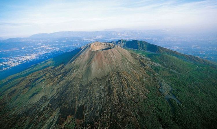
Mount Vesuvius, an iconic stratovolcano located in southern Italy, stands as a testament to the raw power of nature and its profound impact on human history. Situated near the vibrant city of Naples and the picturesque Bay of Naples, Vesuvius is perhaps best known for its catastrophic eruption in 79 AD that buried the ancient Roman cities of Pompeii and Herculaneum under layers of ash and pumice. This event, chronicled by Pliny the Younger, has captivated the imagination of people for centuries and provides an unparalleled window into life in the Roman Empire.
The 79 AD eruption of Mount Vesuvius was a cataclysmic event of staggering proportions. It is estimated to have released 100,000 times the thermal energy of the atomic bomb dropped on Hiroshima in 1945, demonstrating the immense power contained within the Earth’s crust. The eruption sent a towering plume of ash and volcanic gases into the atmosphere, reaching heights of over 20 miles (32 kilometers). This massive column eventually collapsed, sending pyroclastic flows – fast-moving currents of hot gas and volcanic matter – down the slopes of the volcano at speeds of up to 450 mph (724 km/h). These flows, along with the thick layers of ash and pumice, engulfed Pompeii, Herculaneum, and several other settlements, preserving them in a time capsule that would remain sealed for nearly 1700 years.
The preservation of Pompeii and Herculaneum has provided archaeologists with an unprecedented glimpse into daily life in the Roman world. The ash that buried these cities acted as a natural preservative, protecting buildings, artifacts, and even human remains from decay. When excavations began in the 18th century, they revealed streets, houses, and public buildings largely intact, complete with frescoes, mosaics, and everyday objects frozen in time. Perhaps most poignantly, the disaster left behind haunting body casts of its victims, formed when the ash hardened around their bodies, preserving their final moments in striking detail.
While the 79 AD eruption is the most famous, Mount Vesuvius has a long history of volcanic activity. It is considered one of the world’s most dangerous volcanoes due to its explosive eruption style and the densely populated area surrounding it. The volcano has erupted many times since 79 AD, with significant events occurring in 472, 512, 1631, and more recently in 1906 and 1944. The 1906 eruption was particularly violent, causing significant damage to nearby towns and resulting in hundreds of casualties. The most recent eruption in 1944, which occurred during World War II, destroyed several villages and an American bomber squadron.
Today, Mount Vesuvius and its surrounding area form a national park, attracting millions of visitors each year who come to marvel at the volcano and explore the archaeological sites it created. However, the beauty and historical significance of the region are tempered by the ever-present danger posed by the volcano. The area around Vesuvius is now the most densely populated volcanic region in the world, with over 3 million people living within its potential impact zone. This presents significant challenges for emergency planning and disaster management.
6. Sakurajima, Japan
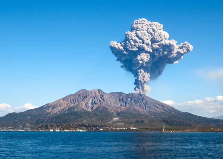
Sakurajima, an active composite volcano located in southern Kyushu, Japan, stands as a testament to the dynamic and ever-changing nature of our planet. Once an island in Kagoshima Bay, Sakurajima has been transformed by its own volcanic activity, becoming connected to the Osumi Peninsula through lava flows from its massive 1914 eruption. This geological landmark is not merely a scenic wonder but a constant reminder of the powerful forces at work beneath the Earth’s surface.
The volcano’s history is marked by periods of intense activity interspersed with quieter phases. The 1914 eruption was a pivotal moment in Sakurajima’s recent history. This event, which began on January 11, 1914, was the most powerful eruption in Japan during the 20th century. It produced massive lava flows that filled the narrow strait between the island and the mainland, creating a permanent land connection. The eruption also caused significant ash fall, with some areas receiving up to 28 inches (72 cm) of ash. Despite the scale of the eruption, there were relatively few casualties, thanks in part to earthquakes that preceded the main event, prompting many residents to evacuate.
Since the 1914 eruption, Sakurajima has entered a phase of persistent activity characterized by frequent small to moderate eruptions. On average, the volcano experiences hundreds of small eruptions each year, making it one of the most active volcanoes in Japan. These eruptions often produce ash plumes that can reach several kilometers into the atmosphere, affecting local communities and occasionally disrupting air traffic.
The persistent activity of Sakurajima has had a significant impact on the surrounding landscape and ecosystem. The frequent ash falls have created the distinctive “white sands” highlands in the region, a unique habitat that supports specialized plant and animal communities adapted to this harsh environment. The volcanic soil, enriched by minerals from the ash, is also highly fertile, supporting agriculture in the areas surrounding the volcano.
Living in the shadow of an active volcano presents numerous challenges for the local population. The city of Kagoshima, located just 8 kilometers (5 miles) from Sakurajima, has had to adapt to life with a constantly erupting neighbor. The city has implemented various measures to cope with the regular ash falls, including specially designed buildings, covered bus stops, and regular street cleaning operations. Residents often carry umbrellas not just for rain, but to protect themselves from falling ash.
The proximity of such a large population to an active volcano necessitates comprehensive monitoring and warning systems. Sakurajima is one of the most closely monitored volcanoes in the world, with a network of seismometers, GPS stations, tiltmeters, and cameras providing real-time data to volcanologists. This data is crucial for predicting potential large-scale eruptions and issuing timely warnings to the public.
Sakurajima serves as a natural laboratory for volcanologists, offering invaluable opportunities to study volcanic processes and improve our understanding of how volcanoes behave. The frequent eruptions allow scientists to test and refine models of volcanic activity, potentially improving our ability to forecast eruptions at other volcanoes around the world. Moreover, the coexistence of a major urban area with an active volcano provides important lessons in disaster preparedness and resilience, offering insights that can be applied to other volcanic regions globally.
7. Mount Merapi, Indonesia
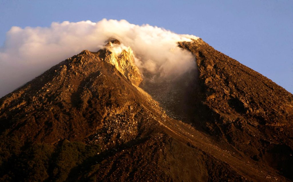
Mount Merapi, a name that translates to “Mountain of Fire” in Indonesian, is a formidable and awe-inspiring presence in the heart of Java, Indonesia’s most populous island. This active stratovolcano, rising to an elevation of 2,911 meters (9,551 feet) above sea level, stands as a testament to the powerful geological forces that have shaped the Indonesian archipelago for millions of years. As part of the infamous Pacific Ring of Fire, Merapi is not just any volcano; it is one of the most active and closely monitored volcanoes in the world, with a history of eruptions that have both fascinated scientists and terrified local populations for centuries.
The volcano’s frequent activity is a result of its location at the subduction zone where the Indo-Australian Plate slides beneath the Eurasian Plate. This tectonic interaction fuels Merapi’s fiery temperament, leading to regular eruptions that range from small, effusive lava flows to large, explosive events that can dramatically alter the surrounding landscape. The volcano’s eruptive pattern is characterized by the growth and collapse of lava domes, often culminating in pyroclastic flows – fast-moving currents of hot gas and volcanic matter that can reach temperatures of up to 1,000°C and travel at speeds of up to 700 km/h. These deadly flows pose the greatest threat to the densely populated areas surrounding the volcano.
The 2010 eruption of Mount Merapi stands out as one of the most significant and devastating events in the volcano’s recent history. Beginning in late October and continuing into November, this eruption was marked by its exceptional intensity and the widespread impact it had on the surrounding region. The event claimed the lives of over 300 people, making it one of the deadliest volcanic disasters of the 21st century. The eruption’s ferocity was such that it forced the evacuation of more than 350,000 people from the volcano’s vicinity, creating a humanitarian crisis that stretched the resources of local and national authorities to their limits.
The 2010 eruption not only resulted in immediate loss of life and displacement but also had long-lasting effects on the region’s ecology and economy. Vast areas of forest and agricultural land were destroyed by pyroclastic flows and lahars (volcanic mudflows), altering the landscape and disrupting livelihoods dependent on farming and forestry. The ash fall from the eruption affected areas far beyond the immediate vicinity of the volcano, causing respiratory problems for residents and disrupting air travel across the region. The scale of destruction and disruption served as a stark reminder of the immense power of volcanic eruptions and the critical importance of effective monitoring and evacuation procedures.
Despite the dangers posed by Mount Merapi, the volcano and its surroundings remain home to thousands of people who have developed a complex relationship with this force of nature. Many local communities have deep cultural and spiritual connections to the volcano, viewing it as a sacred entity that demands respect and reverence. This cultural perspective often intertwines with scientific understanding, creating a unique approach to living with volcanic risk. Local wisdom and traditional practices, passed down through generations, often complement modern scientific monitoring in predicting and responding to volcanic activity.
The ongoing monitoring of Mount Merapi involves a sophisticated network of instruments and observatories managed by the Indonesian Center for Volcanology and Geological Hazard Mitigation (CVGHM). Seismometers, tiltmeters, GPS stations, and gas analyzers work in concert to detect subtle changes in the volcano’s behavior that might precede an eruption. This constant vigilance is crucial for providing early warnings to local authorities and populations, potentially saving thousands of lives. The data collected from Merapi also contributes to global volcanological research, enhancing our understanding of volcanic processes and improving prediction models for eruptions worldwide.
8. Mount Nyiragongo, Congo
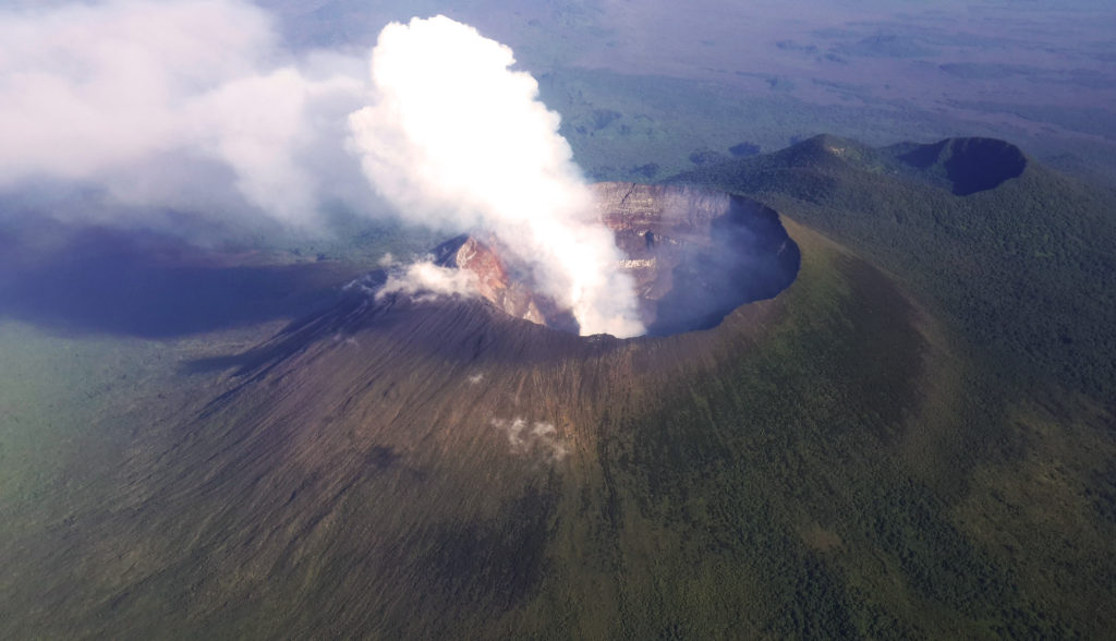
Mount Nyiragongo, an imposing stratovolcano located in the Virunga Mountains of the Democratic Republic of Congo, stands as one of Africa’s most active and potentially dangerous volcanoes. Rising to an elevation of 3,470 meters (11,385 feet), Nyiragongo is renowned for its persistent lava lake, a rare geological feature that has captivated scientists and adventurers alike for decades. This lava lake, often described as a “portal to the Earth’s interior,” is one of the largest and most voluminous known in recent history, offering a unique window into the planet’s molten core.
The volcano’s location within the Virunga National Park, a UNESCO World Heritage site, adds an extra layer of complexity to its management and study. The park is home to critically endangered mountain gorillas and a diverse array of flora and fauna, making the balance between conservation efforts and volcanic risk management particularly challenging. Nyiragongo’s eruptions not only pose a direct threat to wildlife and ecosystems but also to the park’s infrastructure and the livelihoods of communities dependent on ecotourism.
Nyiragongo’s eruptive history is marked by relatively infrequent but extremely hazardous events. The volcano and its neighbor, Nyamuragira, are together responsible for an astounding 40% of Africa’s historical volcanic eruptions. This statistic underscores the significant role these volcanoes play in the continent’s geological landscape. Nyiragongo’s eruptions are characterized by highly fluid lava flows that can travel at exceptional speeds, sometimes reaching up to 60 km/h (37 mph) on the volcano’s steep slopes. This unusual fluidity is due to the low silica content of the lava, which makes it less viscous and allows it to flow more rapidly than lava from many other volcanoes.
The 2002 eruption of Mount Nyiragongo stands out as one of the most catastrophic volcanic events in recent African history. On January 17, 2002, fissures opened on the volcano’s southern flank, sending torrents of lava flowing towards the city of Goma, a major urban center with a population of over 1 million people. The lava flows cut through the heart of the city, destroying approximately 15% of Goma’s buildings and infrastructure. This devastating event resulted in the displacement of over 120,000 people and had far-reaching economic and social impacts on the region. The eruption also triggered a humanitarian crisis as thousands of refugees fled across the border into neighboring Rwanda, straining resources and international aid efforts.
The most recent eruption of Nyiragongo, which occurred in May 2021, served as a stark reminder of the volcano’s ongoing threat to the region. This event, while less destructive than the 2002 eruption, still necessitated the evacuation of tens of thousands of residents from Goma and surrounding areas. The eruption highlighted the continued vulnerability of the local population and the critical importance of improved monitoring and early warning systems.
Monitoring Mount Nyiragongo presents unique challenges due to its location in a region affected by political instability and limited resources. The Goma Volcano Observatory, responsible for monitoring both Nyiragongo and Nyamuragira, operates under difficult conditions, often lacking adequate funding and equipment. Despite these challenges, dedicated volcanologists and technicians work tirelessly to maintain surveillance of the volcano, employing a combination of seismic monitoring, gas emission analysis, and satellite observations. International collaboration plays a crucial role in supporting these efforts, with scientists from around the world contributing expertise and resources to enhance understanding and monitoring of Nyiragongo’s activity.
The presence of Mount Nyiragongo has profound implications for urban planning and development in the region. The rapid growth of Goma and surrounding communities, driven in part by displacement from conflicts in the area, has led to increased population exposure to volcanic hazards. This urbanization, often occurring without adequate consideration of geological risks, underscores the need for integrated approaches to disaster risk reduction that incorporate volcanic hazard assessment into long-term development strategies.
9. Ulawun, Papua New Guinea
Ulawun, often referred to as the “Father” by local inhabitants, is a formidable stratovolcano that dominates the landscape of New Britain Island in Papua New Guinea. Rising to an impressive height of 2,334 meters (7,657 feet), it stands as the highest peak in the Bismarck Archipelago and one of the most active volcanoes in this tectonically dynamic region. Ulawun’s perfect conical shape, a result of countless eruptions over millennia, is a testament to the powerful geological forces at work beneath the Earth’s surface. This volcano is not just a geographical feature; it is a living, breathing entity that has shaped the lives, culture, and environment of the surrounding communities for generations.
The volcanic activity of Ulawun is a direct result of its location along the Pacific Ring of Fire, a vast horseshoe-shaped zone of intense seismic and volcanic activity that encircles much of the Pacific Ocean. This positioning at the convergence of tectonic plates fuels Ulawun’s frequent eruptions, making it one of the most active volcanoes in Papua New Guinea. Since the 18th century, there have been at least 22 recorded major eruptions, a figure that likely underestimates the true frequency of activity due to the remote location and limited historical records of the region.
Ulawun’s eruptive style is characterized by a mix of effusive and explosive activity. Lava flows, ash emissions, and pyroclastic flows are common features of its eruptions. The volcano’s steep slopes and the highly fluid nature of its lava contribute to the potential for rapid and far-reaching lava flows, posing significant risks to nearby communities. Additionally, the ash plumes generated during eruptions can reach considerable heights, sometimes exceeding 20,000 meters (65,000 feet), which not only affects local populations but also poses hazards to aviation in the region.
The most recent major eruption of Ulawun, which occurred in June 2019, served as a stark reminder of the volcano’s power and the vulnerabilities of the surrounding areas. This eruption generated an ash plume that rose to an estimated height of 19 kilometers (63,000 feet), prompting the evacuation of thousands of residents from nearby communities. The event caused significant disruption to daily life, damaged crops and infrastructure, and highlighted the ongoing challenges of living in the shadow of an active volcano. The ash fall from this eruption affected a wide area, contaminating water supplies, damaging vegetation, and posing respiratory risks to both humans and livestock.
The presence of Ulawun has profound implications for the several thousand people who live in its vicinity. These communities have developed a complex relationship with the volcano, balancing the fertile soils and resources it provides with the ever-present risk of eruption. Traditional knowledge and practices related to volcanic activity have been passed down through generations, often complementing modern scientific monitoring efforts. However, the increasing frequency and intensity of eruptions in recent years have strained this delicate balance, forcing communities and authorities to reassess risk management strategies and evacuation plans.
Monitoring Ulawun presents significant challenges due to its remote location and the limited resources available in Papua New Guinea for volcanic surveillance. The Rabaul Volcanological Observatory, responsible for monitoring Ulawun and other volcanoes in the region, employs a range of techniques including seismic monitoring, visual observations, and satellite imagery analysis. International collaboration plays a crucial role in supplementing these efforts, with organizations such as the Volcanic Ash Advisory Center in Darwin, Australia, providing critical support in tracking ash plumes that could affect aviation safety across a wide area of the Southwest Pacific.
The frequent activity of Ulawun not only poses immediate risks to local populations but also has broader implications for the ecology and economy of New Britain Island. Ash fall from eruptions can damage crops, contaminate water sources, and disrupt transportation and communication networks. However, over longer time scales, the volcanic soils enriched by eruptions contribute to the exceptional fertility of the surrounding lands, supporting agriculture and biodiversity. This duality encapsulates the complex relationship between volcanic activity and human development in the region.
As climate change and increasing population pressures amplify the vulnerabilities of communities living near active volcanoes, the case of Ulawun underscores the need for integrated approaches to disaster risk reduction and sustainable development. Enhancing monitoring capabilities, improving early warning systems, and developing robust evacuation plans are critical steps in mitigating the risks posed by Ulawun. Equally important is the need to balance economic development with environmental conservation and risk management, ensuring that the growth of communities in the volcano’s vicinity occurs in a manner that respects the power and unpredictability of this geological giant.
10. Mauna Loa, Hawaii
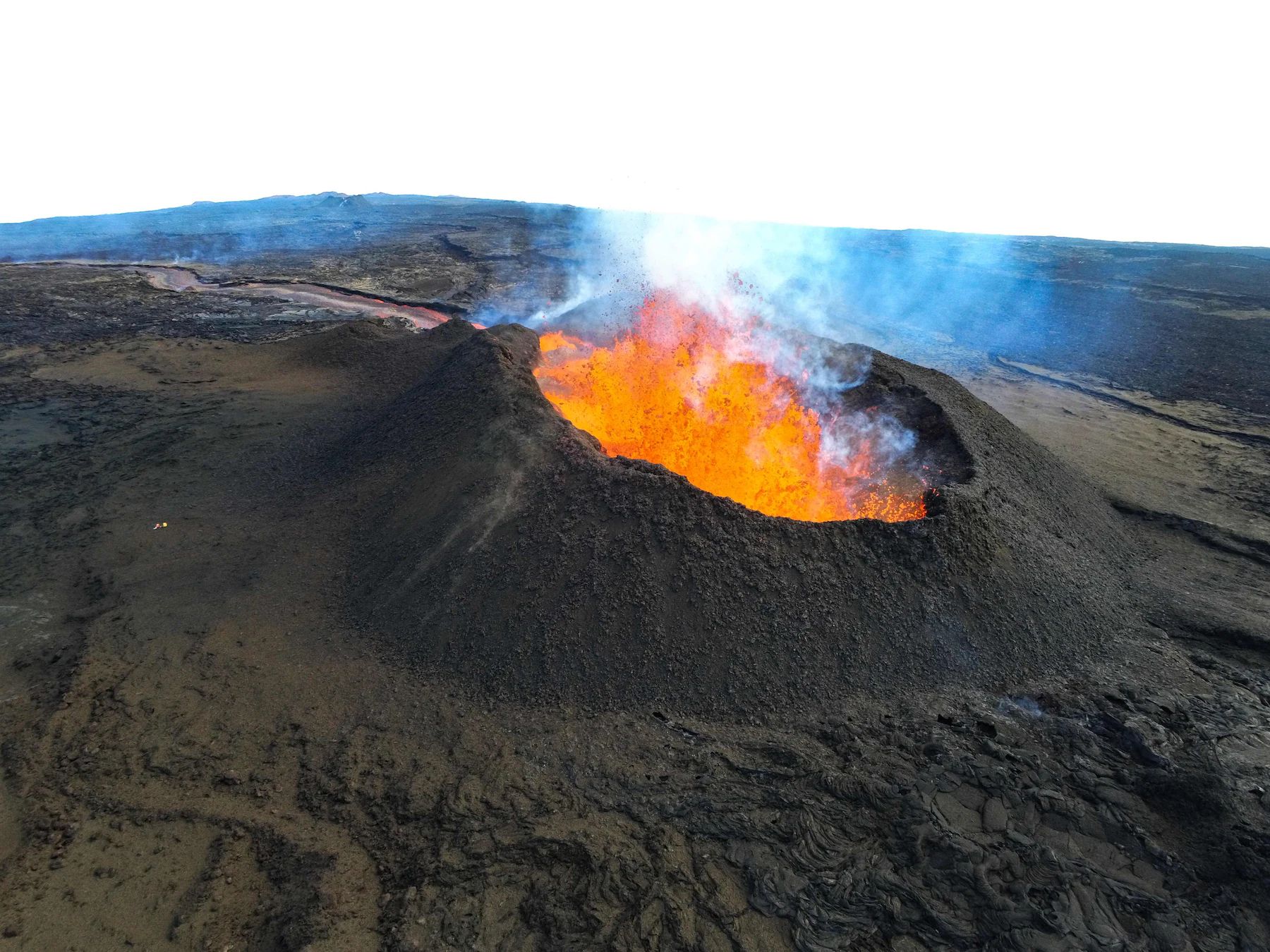
Mauna Loa, a name that translates to “Long Mountain” in Hawaiian, is a colossal shield volcano that dominates the landscape of the Big Island of Hawaii. This geological behemoth is not just impressive in its size and beauty, but also in its geological significance and ongoing activity. Mauna Loa holds the distinction of being one of the largest active volcanoes on Earth, with a volume estimated at approximately 18,000 cubic miles (75,000 cubic kilometers), making it the largest subaerial volcano in both mass and volume.
The sheer scale of Mauna Loa is difficult to comprehend. From its base on the sea floor to its summit, it measures about 30,085 feet (9,170 meters), which is more than 120 meters (394 feet) higher than Mount Everest when measured from base to peak. Its subaerial part rises 13,681 feet (4,169 meters) above sea level, which means that more than half of the volcano’s height is underwater. The volcano’s massive size is a result of countless eruptions over hundreds of thousands of years, slowly building up layer upon layer of hardened lava.
Mauna Loa’s eruptive history is both long and frequent, with 33 documented eruptions since its first well-documented historical eruption in 1843. On average, it erupts every six years, though the period between eruptions can vary significantly. The volcano’s most recent eruption occurred in 1984, which sent lava flows within 4.5 miles (7.2 kilometers) of Hilo, the largest population center on the Big Island. This eruption lasted for 22 days and covered an area of about 48 square kilometers with lava.
One of the most distinctive features of Mauna Loa is its shape. Unlike the steep, conical volcanoes that many people picture when they think of a volcano, Mauna Loa is a shield volcano, characterized by its gently sloping profile. This shape is a result of the highly fluid nature of its lava. The lava erupted from Mauna Loa is typically basaltic, which is low in silica and therefore flows easily, spreading out over large areas rather than building up steep slopes.
The eruptions of Mauna Loa tend to be non-explosive, which is another characteristic of its basaltic lava. Instead of violent explosions, eruptions often begin with the opening of fissures and the emergence of lava fountains. These fountains can reach heights of several hundred feet, creating spectacular displays of nature’s power. As the eruption progresses, lava flows can travel long distances, sometimes threatening nearby communities.
Despite its frequent activity, Mauna Loa poses less immediate danger to human populations compared to some other active volcanoes. This is partly due to its relatively predictable behavior and the extensive monitoring systems in place. The Hawaiian Volcano Observatory, operated by the United States Geological Survey, keeps a constant watch on Mauna Loa, using a variety of instruments including seismometers, GPS stations, and gas sensors. This monitoring allows scientists to detect signs of impending eruptions, potentially providing crucial warning time for evacuations if necessary.
However, the volcano’s potential impact should not be underestimated. A major eruption could potentially cut off the main highway on the island, disrupt air travel, and damage infrastructure. The volcano’s size means that its eruptions can affect weather patterns and even contribute to global climate variations. For example, large eruptions can inject significant amounts of sulfur dioxide into the atmosphere, which can have a cooling effect on global temperatures.
Mauna Loa is more than just a geological wonder; it plays a crucial role in Hawaiian culture and mythology. In Hawaiian tradition, the volcano is considered to be the home of Pele, the goddess of fire and volcanoes. The regular eruptions are seen as manifestations of Pele’s power and presence. This cultural significance adds another layer of importance to the ongoing efforts to understand and monitor this remarkable volcano.
11. Galeras, Colombia
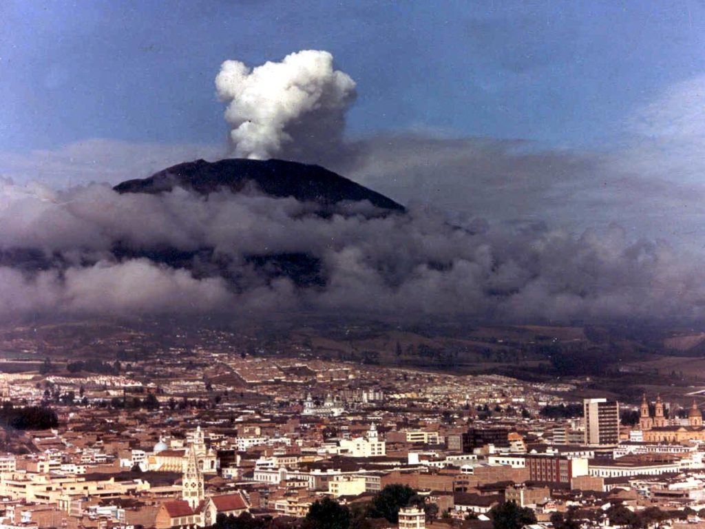
Galeras, an awe-inspiring and formidable active stratovolcano, stands sentinel over the southwestern region of Colombia, near the bustling city of Pasto. With its summit piercing the sky at 4,276 meters (14,029 feet) above sea level, Galeras is not only a prominent geological feature but also a constant reminder of the dynamic forces shaping our planet. This volcano, considered one of the most active in Colombia, has played a significant role in both the natural history and human narrative of the region for centuries.
The recorded history of Galeras’s activity stretches back to the time of the Spanish conquest, with its first documented eruption occurring on December 7, 1580. This event marked the beginning of a long and complex relationship between the volcano and the people living in its shadow. Since then, Galeras has erupted frequently, with more than 20 significant eruptions recorded in the past 500 years. Each eruption has contributed to the shaping of the landscape and the collective memory of the local population.
One of the most notorious events in Galeras’s recent history occurred on January 14, 1993. On this fateful day, the volcano erupted unexpectedly while a group of volcanologists was conducting research inside its crater. The eruption claimed the lives of nine people, including six scientists who had descended into the volcano to sample gases. This tragic event sent shockwaves through the scientific community and highlighted the unpredictable nature of volcanic activity, even for those most familiar with it. It also underscored the importance of developing more advanced monitoring techniques and safety protocols for volcanological fieldwork.
The 1993 eruption, while devastating, was not an isolated incident. Galeras has continued to show significant activity in the years since, with numerous eruptions and periods of unrest. The volcano’s persistent activity has necessitated the development of comprehensive monitoring systems and emergency response plans. The Colombian Geological Survey (Servicio Geológico Colombiano) maintains a dedicated Volcanological and Seismological Observatory in Pasto, which keeps a constant vigil on Galeras using a variety of instruments including seismometers, gas analyzers, and deformation monitoring equipment.
Living in proximity to an active volcano like Galeras presents unique challenges for the local population. The city of Pasto, with a population of over 450,000, sits just 9 kilometers from the volcano’s summit. This close coexistence of a major urban center and an active volcano necessitates a delicate balance between economic development and safety considerations. The local government and scientific institutions have worked to implement evacuation plans and public education programs to ensure the community is prepared for potential volcanic events.
Despite the dangers it poses, Galeras also brings benefits to the region. The volcanic soil in the area is exceptionally fertile, supporting rich agricultural production. The volcano and its surrounding landscape have also become important tourist attractions, drawing visitors from around the world who are eager to witness the raw power of nature. However, this tourism must be carefully managed to ensure the safety of visitors and to protect the delicate ecological balance of the volcanic environment.
Galeras serves as a natural laboratory for volcanologists, offering valuable opportunities to study volcanic processes and improve our understanding of how these complex systems behave. The frequent activity allows scientists to test and refine models of volcanic behavior, potentially improving our ability to forecast eruptions at other volcanoes around the world. Moreover, the lessons learned from monitoring and managing the risks associated with Galeras have applications far beyond Colombia, informing volcanic risk management strategies globally.
As we look to the future, Galeras remains a focal point of scientific interest and a source of both concern and fascination for those who live in its vicinity. Its continued activity serves as a poignant reminder of the dynamic nature of our planet and the need for ongoing vigilance and research in the face of natural hazards. The story of Galeras is far from over, and each new chapter in its geological history offers fresh insights into the powerful forces at work beneath the Earth’s surface.
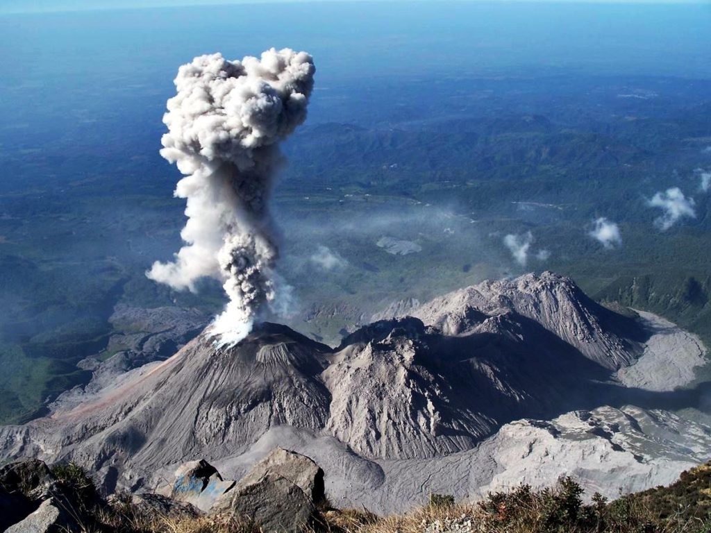
12. Santa María, Guatemala
Santa María, an active stratovolcano located in the western highlands of Guatemala, stands as a testament to the raw power of nature and its profound impact on human history. Situated near the city of Quetzaltenango, Guatemala’s second-largest urban center, Santa María has played a pivotal role in shaping both the physical landscape and the cultural fabric of the region. Its violent eruptions have left an indelible mark on the collective memory of the Guatemalan people and have significantly influenced the field of volcanology.
The volcano’s most infamous eruption occurred in 1902, an event that would go down in history as one of the most catastrophic volcanic disasters of the 20th century. On October 24, 1902, after a period of increased seismic activity, Santa María erupted with devastating force. The eruption was one of the largest of the 20th century and ranks among the top five most powerful eruptions of the past 200 years. The explosion was heard as far away as Costa Rica, and ash fell over an area of about 273,000 square kilometers (105,000 square miles), reaching as far as San Francisco, California.
The 1902 eruption of Santa María was characterized by its extreme violence and the volume of material ejected. It produced a towering eruption column that reached heights of up to 28 kilometers (17 miles) into the atmosphere. The collapse of this eruption column generated massive pyroclastic flows that devastated the surrounding landscape. The eruption also produced large amounts of volcanic ash and pumice, which blanketed the region and caused widespread destruction.
The human toll of the 1902 eruption was staggering. While exact figures are difficult to determine due to the chaos that ensued, it is estimated that at least 5,000 people lost their lives as a direct result of the eruption. Many more suffered from the long-term effects of the disaster, including respiratory problems from ash inhalation and the loss of livelihoods due to the destruction of agricultural land. The eruption had a profound impact on the local economy, destroying coffee plantations that were a major source of income for the region.
In the aftermath of the 1902 eruption, the landscape around Santa María was forever changed. The eruption left a massive crater on the southwest flank of the volcano, which would later become the site of a new volcanic dome known as Santiaguito. This dome began forming in 1922 and has been in a state of near-constant eruption ever since, making it one of the most active volcanic vents in the world.
The ongoing activity of Santiaguito presents both challenges and opportunities for scientists and local communities. The frequent eruptions, while generally smaller in scale than the 1902 event, still pose significant hazards. Ash falls can damage crops and infrastructure, while lahars (volcanic mudflows) threaten communities and agricultural lands in the volcano’s drainage basins. However, the persistent activity also provides volcanologists with invaluable opportunities to study long-term eruptive behavior and test new monitoring techniques.
The legacy of Santa María’s 1902 eruption extends far beyond its immediate impacts. It played a crucial role in advancing our understanding of explosive volcanism and contributed to the development of modern volcanology. The eruption highlighted the need for improved volcano monitoring and risk assessment, leading to increased scientific attention on active volcanoes worldwide. Today, Santa María and Santiaguito are among the most closely monitored volcanic systems in Central America, with a network of instruments providing real-time data to scientists and emergency management officials.
Despite the dangers it poses, Santa María also plays a significant role in Guatemala’s cultural and economic landscape. The volcano and its surrounding area have become important tourist destinations, attracting visitors who are drawn to its dramatic scenery and the opportunity to witness volcanic activity firsthand. However, this tourism must be carefully managed to ensure the safety of visitors and to protect the fragile ecosystem of the volcanic environment.
As we reflect on the history of Santa María and look towards the future, it serves as a powerful reminder of the need for continued vigilance and research in the face of natural hazards. The volcano’s ongoing activity underscores the importance of maintaining robust monitoring systems, developing effective emergency response plans, and fostering public awareness about volcanic risks. The story of Santa María is a testament to both the destructive power of nature and human resilience in the face of adversity, offering valuable lessons for communities living in volcanic regions around the world.