### 1. The Wave (Arizona, USA)
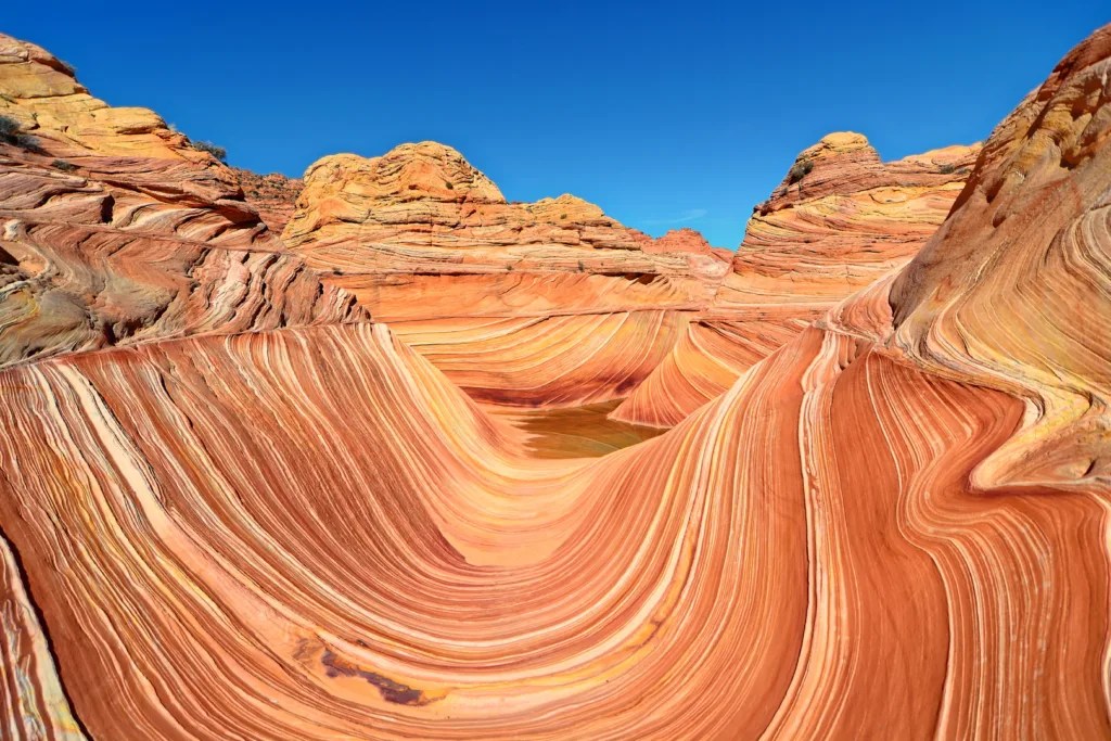 The Wave, nestled in the Coyote Buttes area of the Paria Canyon-Vermilion Cliffs Wilderness in Arizona, USA, stands as a testament to the extraordinary artistry of nature. This mesmerizing sandstone formation has captivated visitors for years with its unique geological features, undulating patterns, and vibrant colors. The Wave’s allure lies not only in its visual beauty but also in the fascinating geological processes that shaped it over millions of years.
Formed through a complex interplay of erosion, deposition, and geological processes, the sandstone layers of The Wave showcase the remnants of ancient dunes that once dominated the landscape. The characteristic swirled patterns that give The Wave its name are a result of different mineral compositions within the rock and the intricate interaction of wind and water over vast periods of time. These forces have sculpted the sandstone into smooth, wavelike forms that seem to flow across the landscape, creating an otherworldly and almost hypnotic visual effect.
The formation is primarily composed of Navajo Sandstone, a geological layer that was deposited during the Jurassic period, approximately 190 million years ago. This soft and cross-bedded sandstone created an ideal canvas for the sculpting forces of nature. Over time, wind and water erosion carved away at the rock, revealing the stunning patterns and colors we see today. The vibrant hues of red, orange, yellow, and pink that streak through The Wave are the result of various minerals present in the sandstone, including iron oxides, manganese, and limonite.
Due to its delicate nature and the fragility of the sandstone formations, access to The Wave is limited and tightly regulated to preserve its pristine condition. The Bureau of Land Management, which oversees the area, grants only a limited number of permits daily through a lottery system. This strict control ensures the protection and conservation of this natural masterpiece, allowing it to remain unspoiled for future generations to appreciate and study.
Visiting The Wave provides a unique opportunity to witness the intricate artistry of geological processes and immerse oneself in a breathtaking and otherworldly landscape. The journey to The Wave itself is an adventure, requiring a challenging 3-mile hike each way through unmarked desert terrain. This remote location and the physical effort required to reach it add to the sense of discovery and wonder that visitors experience upon arriving at the formation.
The Wave’s geological significance extends beyond its visual appeal. It serves as a valuable resource for scientists studying the processes of erosion and the formation of desert landscapes. The intricate patterns and layers visible in the rock provide insights into ancient environments and climate conditions, offering a window into Earth’s distant past.
### 2. Giant’s Causeway (Northern Ireland)
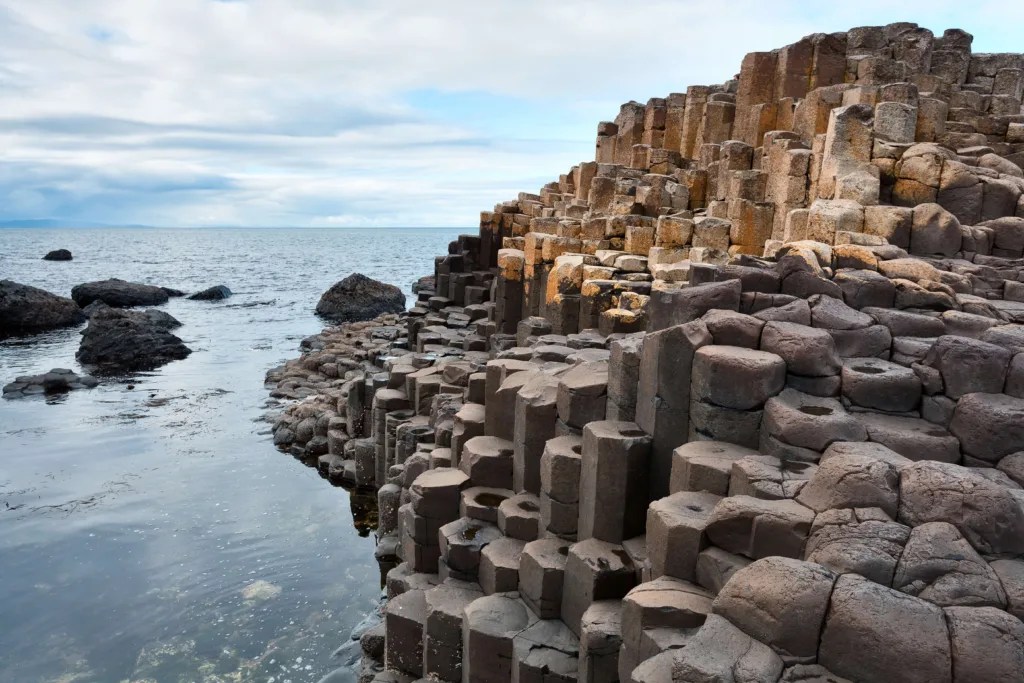 The Giant’s Causeway, located on the rugged northeast coast of Northern Ireland, stands as an iconic and extraordinary rock formation that has captivated visitors and scientists alike for centuries. Recognized as a UNESCO World Heritage Site, this geological wonder draws tourists from around the globe, offering a unique glimpse into the Earth’s volcanic past and the power of natural forces to shape our landscape.
This remarkable formation consists of approximately 40,000 interlocking basalt columns that create a grand mosaic resembling a giant pathway leading into the sea. The majority of these columns are hexagonal in shape, although some display fewer or more sides, adding to the intrigue of the site. The tallest of these columns reach impressive heights of up to 12 meters (39 feet), creating a dramatic and awe-inspiring sight against the backdrop of the turbulent North Atlantic Ocean.
The formation of the Giant’s Causeway dates back approximately 50-60 million years to a period of intense volcanic activity in the region. During this time, massive amounts of molten basaltic lava erupted from fissures in the Earth’s crust. As this lava cooled and solidified, it contracted and cracked, creating the distinctive hexagonal columns we see today. This process, known as columnar jointing, is responsible for the Causeway’s unique appearance. The precise and uniform nature of these columns continues to be a subject of scientific study and fascination, offering insights into volcanic processes and the cooling properties of basaltic lava.
While the scientific explanation for the Giant’s Causeway is well-established, local folklore adds an intriguing and enchanting dimension to the site. According to legend, the columns were created by a giant named Finn McCool, who built the causeway as a bridge to Scotland to confront his rival giant, Benandonner. Various features of the landscape are woven into this tale, including the Giant’s Boot, the Wishing Chair, and the Giant’s Harp, each adding to the mythical allure of the site. This blend of scientific wonder and folkloric charm makes the Giant’s Causeway a unique cultural and natural heritage site.
In addition to the famous columns, the Giant’s Causeway boasts a diverse and dramatic coastal landscape. Visitors can explore stunning cliffs, hidden caves, and breathtaking views of the North Atlantic Ocean. The site is also home to a rich variety of plant and animal life, including rare and protected species, making it a haven for nature enthusiasts and researchers alike.
The Giant’s Causeway serves as more than just a tourist attraction; it is a vital site for geological research and education. Scientists continue to study the formation to gain insights into volcanic processes and the Earth’s history. The site also plays a crucial role in educating the public about geology, conservation, and the importance of preserving our natural heritage for future generations.
### 3. The Twelve Apostles (Victoria, Australia)
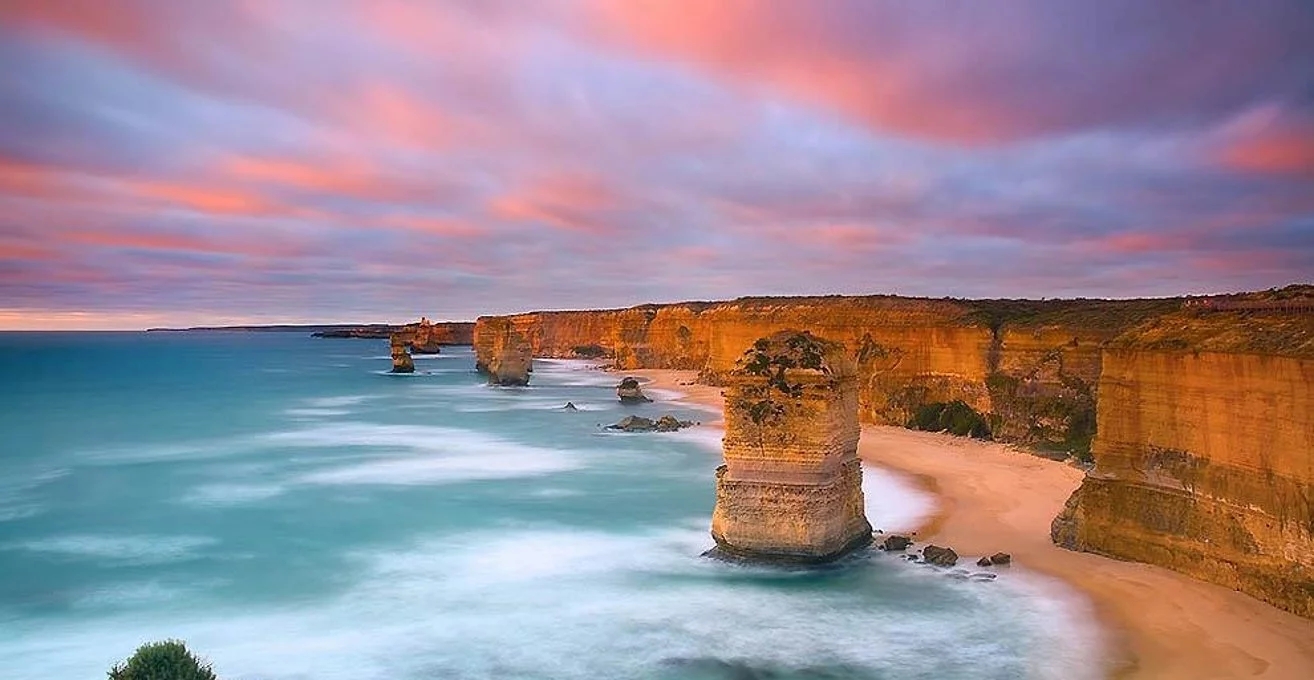 The Twelve Apostles, a striking rock formation located along the dramatic coastline of Victoria, Australia, stands as one of the country’s most iconic natural landmarks. Despite its name suggesting a dozen formations, there are currently only eight limestone stacks remaining, as the relentless forces of erosion continue to shape and reshape this dynamic landscape. These towering pillars, rising majestically from the Southern Ocean, offer visitors a breathtaking spectacle and a vivid illustration of the ongoing geological processes that shape our planet.
These impressive limestone pillars, some reaching heights of up to 45 meters (148 feet), were formed through a complex geological process spanning millions of years. The formation began around 20 million years ago when the area that is now the coastline of Victoria was submerged beneath the sea. Over an extended period, the accumulation of marine sediment, including the remains of countless shells and marine organisms, gradually built up on the seafloor. As time passed, this sediment compacted and solidified into limestone, forming the foundation of what would eventually become the Twelve Apostles.
The process that transformed this underwater limestone deposit into the towering sea stacks we see today was driven by the relentless pounding of the Southern Ocean waves. Over millions of years, these powerful waves gradually carved out caves in the soft limestone cliffs. As the caves grew larger and deeper, they eventually eroded through the headland, leaving behind isolated pillars of more resistant rock. This process of erosion is ongoing, with the constant action of wind and waves continuing to shape the Apostles and the surrounding coastline.
While erosion is an ever-present force, the limestone cliffs surrounding the Twelve Apostles are composed of a more resistant type of limestone known as the Port Campbell Limestone. This harder limestone provides some protection to the remaining stacks, slowing the rate of erosion to some extent. However, the process is still ongoing, and over time, more of the Apostles will inevitably succumb to the forces of nature. In fact, one of the stacks collapsed in 2005, serving as a dramatic reminder of the dynamic nature of this coastline.
The Twelve Apostles is not only a geological wonder but also an iconic landmark of Australia, drawing countless visitors each year to witness the grandeur of nature’s sculpting power along the breathtaking Great Ocean Road. The site offers various viewing platforms that allow visitors to appreciate the scale and beauty of the formations from different angles. At sunset, the Apostles take on a golden hue, creating a particularly spectacular sight that has become a favorite among photographers and nature enthusiasts.
Beyond their geological significance, the Twelve Apostles and the surrounding area hold important ecological value. The waters around the formations are part of the Twelve Apostles Marine National Park, which protects a diverse array of marine life, including seals, penguins, and numerous fish species. The park also encompasses various underwater canyons and limestone formations that mirror the structures visible above the water’s surface.
### 4. Moeraki Boulders (New Zealand)
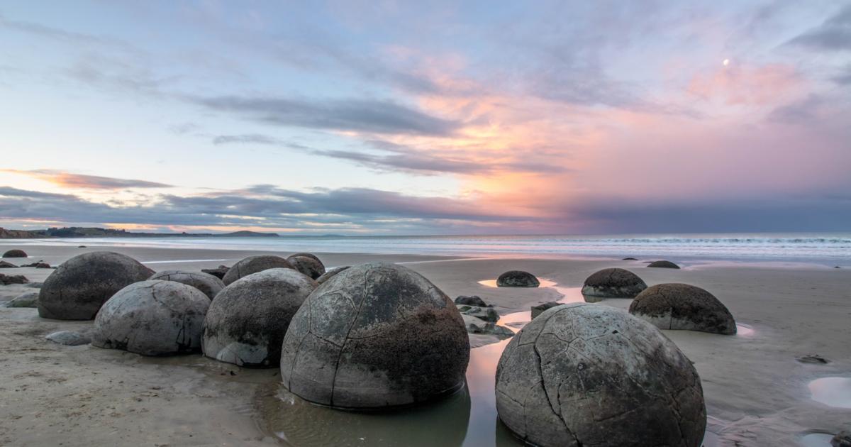 The Moeraki Boulders, found along the picturesque Koekohe Beach in Otago, New Zealand, are a unique and captivating natural phenomenon that has intrigued visitors and scientists alike for generations. These large, spherical boulders, often whimsically referred to as “dragon eggs” or “alien eggs,” create a surreal and enchanting sight against the backdrop of the Pacific Ocean. Their perfectly round shapes and seemingly deliberate arrangement along the beach have sparked curiosity and wonder, making them one of New Zealand’s most photographed geological features.
These remarkable boulders are concretions, formed by the gradual accumulation of sediment around a central nucleus over millions of years. The process begins with the deposition of calcium carbonate and other minerals in layers around a core, which could be a fossil, a piece of shell, or even a grain of sand. As more layers form over time, the sediment gradually hardens and solidifies into the spherical shapes we see today. This process of formation is similar to how a pearl forms within an oyster, albeit on a much larger scale and over a vastly longer period.
What makes the Moeraki Boulders particularly fascinating is their impressive size and near-perfect spherical shape. Some of these boulders reach up to 3 meters (10 feet) in diameter and can weigh several tons. Their spherical forms are a result of natural erosion over time. As the softer mudstone and siltstone surrounding the concretions gradually wear away due to the action of wind, rain, and sea, the harder, more resistant boulders are left behind, creating the striking scene visible today.
The Moeraki Boulders have become a popular tourist attraction, drawing visitors from around the world who come to marvel at their sheer size, unusual arrangement along the beach, and the mystery surrounding their formation. The best time to view the boulders is at low tide when more of them are exposed and accessible. As the tide changes, some boulders become partially submerged, adding to the dynamic and ever-changing nature of the site.
Beyond their geological significance, the Moeraki Boulders hold cultural importance for the local Maori people. According to Maori legend, the boulders are the remains of eel baskets, calabashes, and kumara (sweet potatoes) washed ashore from the wreck of Arai-te-uru, a large sailing canoe. This legend adds a layer of cultural richness to the site, intertwining natural wonder with indigenous storytelling and heritage.
The site of the Moeraki Boulders also offers insights into the geological history of the area. The boulders are estimated to have taken about 4 to 5.5 million years to form, and some are still in the process of being exposed as coastal erosion continues. This ongoing process of revelation adds an element of anticipation and discovery to the site, as new boulders may emerge over time.
### 5. Zhangjiajie National Forest Park (China)
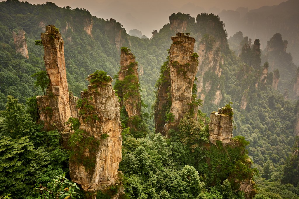 Zhangjiajie National Forest Park, located in the Hunan Province of China, is a mesmerizing and otherworldly landscape that has inspired awe and wonder in visitors from around the globe. This extraordinary park, part of the larger Wulingyuan Scenic Area, is renowned for its towering sandstone pillars, lush greenery, and breathtaking vistas. The unique geological formations found here served as the inspiration for the floating Hallelujah Mountains in James Cameron’s blockbuster movie “Avatar,” bringing international attention to this natural wonder.
The park’s most distinctive features are its towering quartzite sandstone pillars, some of which reach heights of over 200 meters (656 feet). These pillars, often shrouded in mist, create a surreal and almost mystical atmosphere, giving the impression of a landscape straight out of a fantasy world. The formation of these “avatar mountains” or “stone forests” is the result of millions of years of geological processes, including uplift, erosion, and weathering.
The unique geological formations in Zhangjiajie began to take shape around 380 million years ago during the Silurian period. At that time, the area was covered by an ancient sea. Over millions of years, sediments accumulated on the seabed, eventually forming layers of sandstone. Tectonic activity later lifted these layers above sea level, exposing them to the forces of erosion. The process of formation continued through the ages, with water from rainfall and streams gradually eroding the softer parts of the rock, leaving behind the harder, more resistant pillars we see today.
What makes Zhangjiajie National Forest Park truly remarkable is not just its geological formations, but also the dense vegetation that blankets the landscape. Lush forests, hanging vines, and a variety of plant species thrive in this unique environment, adding an ethereal and almost mystical atmosphere to the already awe-inspiring scenery. The interplay between the stark, vertical rock formations and the vibrant green vegetation creates a striking visual contrast that is unparalleled in nature.
The park is also home to a rich biodiversity, including several endemic plant and animal species. The unique ecosystem that has developed here supports a wide array of life, from rare plants clinging to the sides of the towering pillars to diverse wildlife inhabiting the forests below. This biodiversity adds another layer of interest for visitors and researchers alike, making Zhangjiajie not just a geological wonder but also an important site for ecological study and conservation.
Visitors to Zhangjiajie National Forest Park can explore the landscape through a network of hiking trails, offering up-close encounters with the towering pillars and lush forests. For those seeking a bird’s-eye view, the park offers several observation decks and glass walkways that provide panoramic vistas of the stunning scenery. Perhaps the most thrilling way to experience the park is by taking a ride on the Bailong Elevator, the world’s highest outdoor lift, which ascends 326 meters (1,070 feet) up the side of a cliff, offering breathtaking views of the surrounding landscape.
Zhangjiajie National Forest Park’s extraordinary beauty, combined with its cultural and natural significance, led to its designation as a UNESCO Global Geopark in 2004. This recognition underscores the park’s importance not only as a site of natural beauty but also as an area of significant geological interest and educational value. The park continues to be a destination that showcases the power and magnificence of nature, leaving visitors with a profound sense of awe and appreciation for the world’s natural wonders.
### 6. The Chocolate Hills (Bohol, Philippines)
 The Chocolate Hills, located on the island of Bohol in the Philippines, is a geological marvel and one of the most famous natural attractions in the country. This unique landscape comprises over 1,200 uniformly cone-shaped hills spread across an area of approximately 50 square kilometers (20 square miles), creating a breathtaking and surreal vista that has captivated visitors for generations. The hills’ distinctive appearance and the mystery surrounding their formation have made them a subject of both scientific interest and local folklore.
These distinct and symmetrical hills are primarily composed of limestone covered in lush green grass, which turns brown during the dry season, giving them their chocolate-like appearance and hence their name. The origin of the Chocolate Hills dates back thousands of years and is linked to complex geological processes that have shaped the landscape of Bohol over millennia.
The formation of the Chocolate Hills began with the uplift of ancient coral reefs during the Late Pliocene to Early Pleistocene era, approximately 2-5 million years ago. At this time, the area that is now Bohol was submerged beneath a shallow sea. As tectonic forces pushed the land upwards, the coral reefs were exposed and subjected to weathering and erosion. Over time, these processes shaped the limestone into the uniform, cone-shaped hills we see today.
The hills’ remarkable uniformity is one of their most intriguing features and has been a subject of scientific debate. While the exact mechanisms behind their symmetrical shape are still being studied, one prevailing theory suggests that they were formed through a combination of weathering and erosion of the underlying limestone bedrock. The tropical climate of the Philippines, with its alternating wet and dry seasons, played a crucial role in this process. During rainy periods, water would seep into cracks in the limestone, gradually widening them. In dry seasons, the exposed limestone would be subject to wind erosion, further shaping the hills into their distinctive conical forms.
The Chocolate Hills’ unique appearance has given rise to various local legends and folklore. One popular myth tells of a giant who fell in love with a mortal woman. When she died, the giant wept, and his tears turned into the hills. Another legend speaks of two feuding giants who hurled boulders at each other, leaving behind the hills as evidence of their battle. These stories add a layer of cultural richness to the site, intertwining natural wonder with local traditions and storytelling.
Today, the Chocolate Hills stand as a unique and captivating landscape, attracting visitors from around the world. The hills are especially awe-inspiring when viewed from the Chocolate Hills Complex, where an observation deck offers panoramic vistas of this natural wonder. During the rainy season, the hills are covered in lush green vegetation, transforming into their namesake chocolate brown color during the dry months, typically from December to May.
The Chocolate Hills are not just a tourist attraction; they also hold significant ecological importance. The area is home to a variety of plant and animal species, some of which are endemic to the region. The hills and the surrounding landscape provide habitats for diverse flora and fauna, contributing to the biodiversity of the Philippines.
In recognition of their unique geological features and natural beauty, the Chocolate Hills were declared the country’s third National Geological Monument in 1988. This designation highlights the site’s importance not only as a natural wonder but also as an area of significant geological interest and educational value. The hills serve as a natural laboratory for geologists and earth scientists, offering insights into the processes that shape our planet’s surface.
The Chocolate Hills of Bohol represent nature’s ability to create remarkable and enigmatic formations, leaving visitors with a sense of wonder and amazement at the beauty and diversity of our planet’s landscapes. As ongoing research continues to unravel the mysteries of their formation, the Chocolate Hills remain a testament to the complex and fascinating geological processes that have shaped our world over millions of years.
### 7. The Pinnacles (Western Australia)
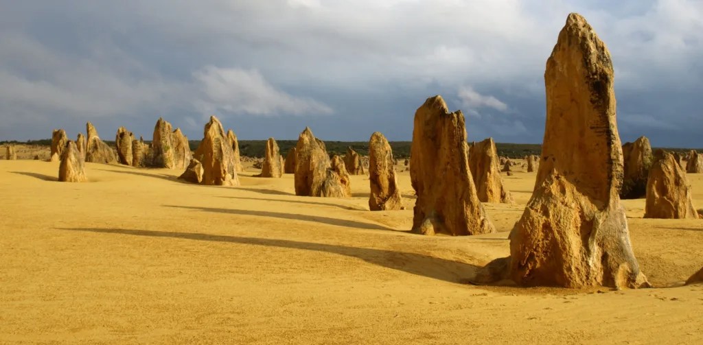 The Pinnacles, located in Nambung National Park in Western Australia, is a unique and captivating rock formation that attracts visitors from around the world. This extraordinary landscape is characterized by thousands of limestone pillars rising from the desert floor, creating an eerie and surreal environment that seems almost otherworldly. The Pinnacles Desert, as it’s often called, covers an area of approximately 190 hectares, offering a stark contrast to the surrounding golden sands and the deep blue of the Indian Ocean visible in the distance.
These remarkable limestone formations were formed over millions of years through a combination of natural processes, including the accumulation of seashells and marine organisms, sedimentation, and erosion. The area’s geological history begins around 25,000 to 30,000 years ago when the sea level was much higher than it is today. During this time, the area that is now the Pinnacles Desert was submerged beneath the ocean.
As sea levels receded, the exposed seabed was rich in shells and other marine deposits. Over time, these shells and organisms became embedded in the sand and limestone deposits. Rainwater, which is slightly acidic, percolated through the sand and dissolved the calcium in the shells and marine sediments. This calcium-rich solution then hardened into a soft limestone layer beneath the surface.
As the climate changed and became more arid, vegetation began to grow on the surface, stabilizing the sand dunes. The roots of this vegetation helped to further cement the underlying limestone. However, as the climate continued to shift, becoming even drier, much of this vegetation died off, leaving the sand exposed once again to the forces of wind erosion.
The wind gradually stripped away the looser sand, revealing the harder limestone formations beneath. These exposed limestone pillars were then further shaped by wind, rain, and other weathering processes, resulting in the distinctive shapes and sizes we see today. Some pillars are thin and delicate, while others are larger and more robust. The Pinnacles range in height from a few centimeters to impressive towers standing up to 3.5 meters (11.5 feet) tall.
The color of the limestone varies from white to yellow, depending on the mineral composition and exposure to the elements. Iron oxide often gives many of the formations a golden or reddish hue, especially striking during sunrise and sunset when the low angle of the sun intensifies these colors.
The Pinnacles’ formation is an ongoing process, with new pillars constantly being exposed and shaped by the forces of nature. This ever-evolving landscape continues to fascinate scientists and visitors alike, offering a glimpse into the dynamic processes that shape our planet’s surface.
Exploring the Pinnacles allows visitors to witness the remarkable beauty and intricacy of natural geological processes. The contrast between the limestone pillars and the surrounding golden desert creates a surreal and otherworldly atmosphere, making it a must-visit destination for those seeking awe-inspiring natural wonders. The best times to visit are early morning or late afternoon when the changing light casts long shadows across the desert, creating dramatic vistas and photo opportunities.
The Pinnacles Desert Discovery Centre, located within the national park, provides visitors with in-depth information about the formation of the Pinnacles, as well as the flora and fauna of the surrounding area. The park is home to a variety of wildlife, including emus, kangaroos, and numerous bird species, adding to the area’s ecological significance.
The Pinnacles serve not only as a geological wonder but also as an important site for scientific research. Geologists and earth scientists continue to study these formations to gain insights into past climates and environmental conditions. The site also provides valuable information about the processes of erosion and the formation of desert landscapes, contributing to our understanding of similar formations around the world.
As a testament to their unique beauty and geological significance, the Pinnacles were declared a national park in 1994. This designation helps to protect these fragile formations and the surrounding ecosystem for future generations to study and admire. The Pinnacles stand as a remarkable example of nature’s artistry, reminding us of the incredible diversity and beauty of our planet’s landscapes.
### 8. Bryce Canyon (Utah, USA)
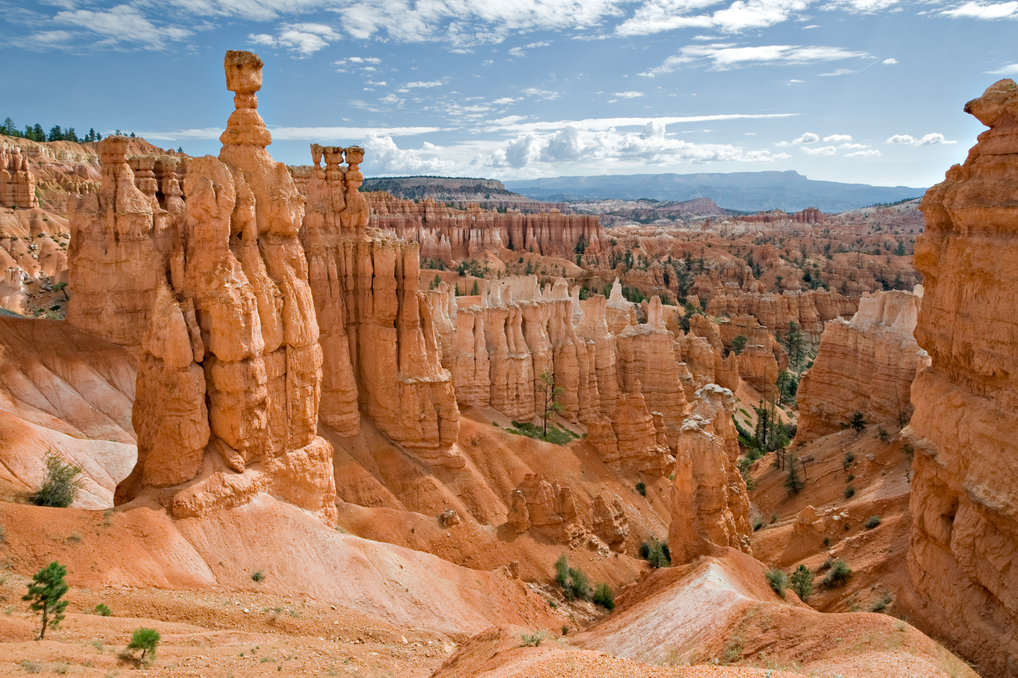 Bryce Canyon, located in southwestern Utah, USA, is a breathtaking and unique geological wonder that mesmerizes visitors with its intricate rock formations and vibrant colors. Despite its name, Bryce Canyon is not actually a canyon but rather a collection of natural amphitheaters carved into the eastern edge of the Paunsaugunt Plateau. This distinctive landscape spans an area of 35,835 acres (14,502 hectares) and is renowned for its otherworldly beauty and geological significance.
The most distinctive feature of Bryce Canyon is its hoodoos—tall, thin spires of rock that protrude from the amphitheaters. These hoodoos have been sculpted by the combined forces of frost wedging and erosion over millions of years, creating a surreal forest of stone that seems to defy gravity. The hoodoos range in height from about 5 to 150 feet (1.5 to 45 meters), with some of the most famous formations, such as Thor’s Hammer and the Silent City, becoming iconic symbols of the park.
The process of hoodoo formation begins when water seeps into the cracks of the limestone and freezes, expanding and exerting pressure on the rock. This process, known as frost wedging, occurs frequently due to the park’s location at high elevation, where temperatures often fluctuate above and below freezing. Over time, this repeated freezing and thawing action breaks down the rock into fin-like ridges. As erosion continues, these ridges are further shaped into the iconic hoodoos seen today. The softer rock erodes more quickly, while the harder capstones protect the columns beneath, resulting in their distinctive shapes.
The colors of Bryce Canyon are also a marvel to behold. The rocks display a stunning palette of red, orange, pink, and white hues, which are the result of different mineral deposits in the limestone and the effects of oxidation. Iron oxide minerals produce the reds, oranges, and yellows, while manganese oxide creates shades of pink and purple. The interplay of light and shadow on these colorful formations throughout the day creates an ever-changing spectacle, with sunrise and sunset offering particularly dramatic views.
Geologically, Bryce Canyon is part of the Grand Staircase, an immense sequence of sedimentary rock layers that stretch from Bryce Canyon National Park through Zion National Park and into the Grand Canyon. This sequence of rock layers provides a unique record of Earth’s history, spanning more than 600 million years. The oldest rocks visible in Bryce Canyon were deposited about 100 million years ago when the area was covered by a shallow sea.
Visiting Bryce Canyon offers visitors a chance to explore its vast network of trails, allowing for up-close encounters with the hoodoos and panoramic views of the amphitheaters. The Rim Trail provides stunning overlooks of the main amphitheater, while trails like Navajo Loop and Queen’s Garden allow hikers to descend among the hoodoos, offering a unique perspective of these geological wonders.
The park also offers exceptional stargazing opportunities due to its designation as an International Dark Sky Park. The absence of light pollution and the high elevation provide ideal conditions for observing the night sky, with the Milky Way often visible to the naked eye. The park hosts astronomy programs and star parties, allowing visitors to explore the wonders of the universe against the backdrop of Bryce Canyon’s otherworldly landscape.
Bryce Canyon’s unique geological formations, vibrant colors, and natural splendor make it an unforgettable destination. It serves as a testament to the power of erosion and the intricate beauty that nature can sculpt over millions of years. The park not only offers visual spectacles but also provides valuable insights into geological processes, climate change, and the history of our planet. As visitors walk among the hoodoos or gaze out over the vast amphitheaters, they are reminded of the immense scale of geological time and the ever-changing nature of our Earth’s surface.
### 9. Giant Buddha of Leshan (Sichuan, China)
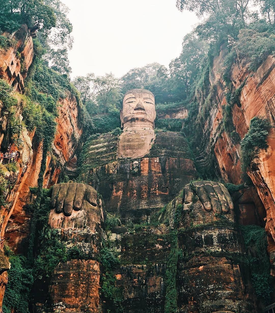 The Giant Buddha of Leshan, located in Sichuan Province, China, is an awe-inspiring and monumental statue that holds great cultural, historical, and artistic significance. Carved out of a cliff face overlooking the confluence of the Minjiang, Dadu, and Qingyi rivers, this colossal statue stands as the largest stone Buddha in the world and has become an iconic landmark of Chinese Buddhism and sculptural artistry.
The construction of the Giant Buddha began during the Tang Dynasty in 713 AD and took an astonishing 90 years to complete, finally finishing in 803 AD. It was commissioned by a Buddhist monk named Hai Tong, who hoped that the Buddha would calm the turbulent waters of the nearby rivers that posed a threat to passing boats. Legend has it that Hai Tong believed the Buddha would protect the local people from the dangerous waters that had claimed many lives.
The statue measures a staggering 71 meters (233 feet) in height and depicts Maitreya, the future Buddha, in a seated position. The scale of the statue is truly impressive, with intricate details and proportions that have amazed visitors for centuries. Its head alone is about 14.7 meters (48 feet) tall, with each eyebrow measuring 5.6 meters (18 feet) in length. The Buddha’s ears are 7 meters (23 feet) long, and its shoulders span an impressive 28 meters (92 feet) across. Perhaps most remarkably, the Buddha’s big toe is large enough to comfortably seat several people.
The statue was meticulously carved out of the red sandstone cliff face, employing intricate stone-cutting techniques of the time. The construction involved overcoming numerous technical challenges and required the removal of large amounts of rock, resulting in significant alterations to the cliff’s landscape. The craftsmen who worked on the project developed innovative drainage systems within the statue to prevent weathering and erosion, a testament to their engineering skills and foresight.
The Giant Buddha of Leshan stands as a testament to the skill and craftsmanship of ancient Chinese artisans. Its construction not only provided a solution to the river’s turbulent waters but also symbolized the devotion and reverence for Buddhism in the region. The statue’s serene expression and powerful presence have inspired countless visitors over the centuries, serving as a focal point for spiritual reflection and artistic appreciation.
Today, the Giant Buddha of Leshan is a UNESCO World Heritage Site, recognized for its historical, cultural, and artistic value. It attracts millions of visitors each year who come to admire its grandeur and spiritual significance. Visitors can view the Buddha from boats on the river or climb the stairs carved into the cliff face for a closer look at the statue’s intricate details.
The site surrounding the Giant Buddha is also of great interest, featuring numerous temples, pagodas, and other religious structures that date back to various periods in Chinese history. These include the Lingyun Temple complex at the top of the cliff and the Wuyou Temple across the river, both of which offer stunning views of the Buddha and the surrounding landscape.
Conservation efforts have been ongoing to protect the Giant Buddha from the effects of weathering, pollution, and the increasing number of visitors. In recent years, experts have implemented measures to clean the statue, repair damaged areas, and monitor its condition to ensure its preservation for future generations.
The Giant Buddha of Leshan is more than just a remarkable feat of ancient engineering and artistry; it is a symbol of the enduring power of faith, the ingenuity of human creativity, and the harmonious relationship between human endeavor and the natural world. As it continues to stand watch over the rivers below, the Giant Buddha remains a testament to the rich cultural heritage of China and an enduring source of wonder for all who visit.
### 10. Tsingy de Bemaraha National Park (Madagascar)
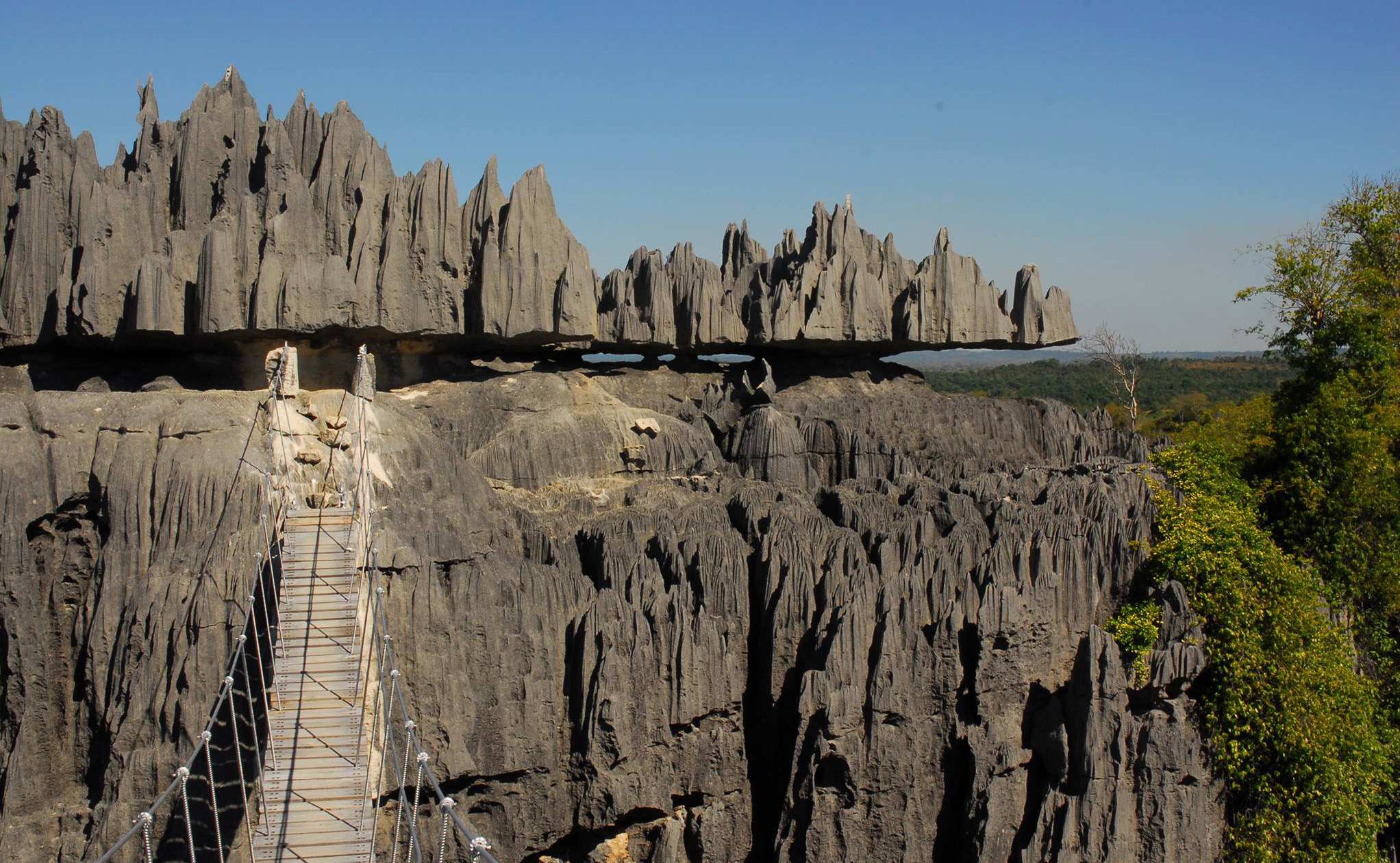 Tsingy de Bemaraha National Park, located in western Madagascar, is a truly unique and otherworldly landscape characterized by its sharp limestone formations known as “tsingy.” The word “tsingy” translates to “where one cannot walk barefoot” in the local Malagasy language, aptly referring to the razor-sharp nature of these remarkable geological formations. This UNESCO World Heritage Site spans an area of around 1,575 square kilometers (608 square miles) and is renowned not only for its exceptional geological features but also for its extraordinary biodiversity, including rare and endemic plant and animal species.
The tsingy formations in the park are the result of millions of years of complex geological processes. The story of their creation begins approximately 200 million years ago when the region was submerged beneath a shallow sea. Over time, layers of limestone sediment accumulated on the seafloor, eventually forming a massive limestone plateau. As tectonic forces lifted this plateau above sea level, it became exposed to the elements, setting the stage for the dramatic erosion that would shape the tsingy.
Over millions of years, rainwater, which is slightly acidic, gradually dissolved the limestone, carving deep fissures, gorges, and razor-sharp pinnacles. This process, known as karst erosion, has sculpted the landscape into a vast expanse of limestone needles. These pinnacles can reach heights of up to 50 meters (164 feet), creating a stone forest that stretches as far as the eye can see. The result is a surreal and breathtaking landscape that seems almost alien in its appearance.
The unique geology of Tsingy de Bemaraha has created a variety of microclimates and habitats, fostering an incredible diversity of plant and animal life. The park is home to numerous endemic species that have adapted to life among the sharp limestone formations. These include several species of lemurs, such as the Decken’s sifaka and the fat-tailed dwarf lemur, as well as various bat species that roost in the numerous caves and crevices.
The flora of the park is equally diverse and specialized. Plants have adapted to grow in the limited soil found in cracks and crevices of the tsingy. Many species are endemic to the park, including several types of baobab trees and aloes. The contrast between the stark, grey limestone and the pockets of lush vegetation creates a striking visual landscape.
Exploring Tsingy de Bemaraha National Park is a challenging but rewarding experience. Walking through the tsingy requires navigating a network of narrow trails, suspension bridges, and ladders. The park has developed a series of via ferrata routes (protected climbing routes) that allow visitors to safely explore this rugged terrain. These routes offer breathtaking views and a unique perspective on the tsingy formations.
The park also features other geological wonders, including deep gorges, caves, and underground rivers. The Manambolo River cuts through the southern part of the park, creating a stunning gorge that visitors can explore by canoe. This river system has played a crucial role in shaping the landscape and continues to influence the park’s ecology.
Tsingy de Bemaraha National Park is not just a geological wonder; it also holds cultural significance for the local Malagasy people. The area has been inhabited for centuries, and evidence of human activity, including ancient burial sites, can be found within the park. Local communities continue to live in the surrounding areas, and their traditional knowledge and practices play an important role in the conservation of this unique ecosystem.
The park faces several conservation challenges, including habitat loss due to deforestation and agricultural encroachment in surrounding areas. Climate change also poses a threat, potentially altering the delicate balance of the park’s ecosystems. Efforts are ongoing to protect this unique landscape and its biodiversity, involving local communities in conservation initiatives and sustainable tourism development.
Tsingy de Bemaraha National Park stands as a testament to the incredible diversity of our planet’s landscapes and the complex interplay between geology, climate, and life. Its razor-sharp pinnacles, hidden caves, and diverse ecosystems offer visitors a glimpse into a world unlike any other, challenging our perceptions of what landscapes can be and reminding us of the wonders that still exist in the natural world.