1. The Wave (Arizona, USA)
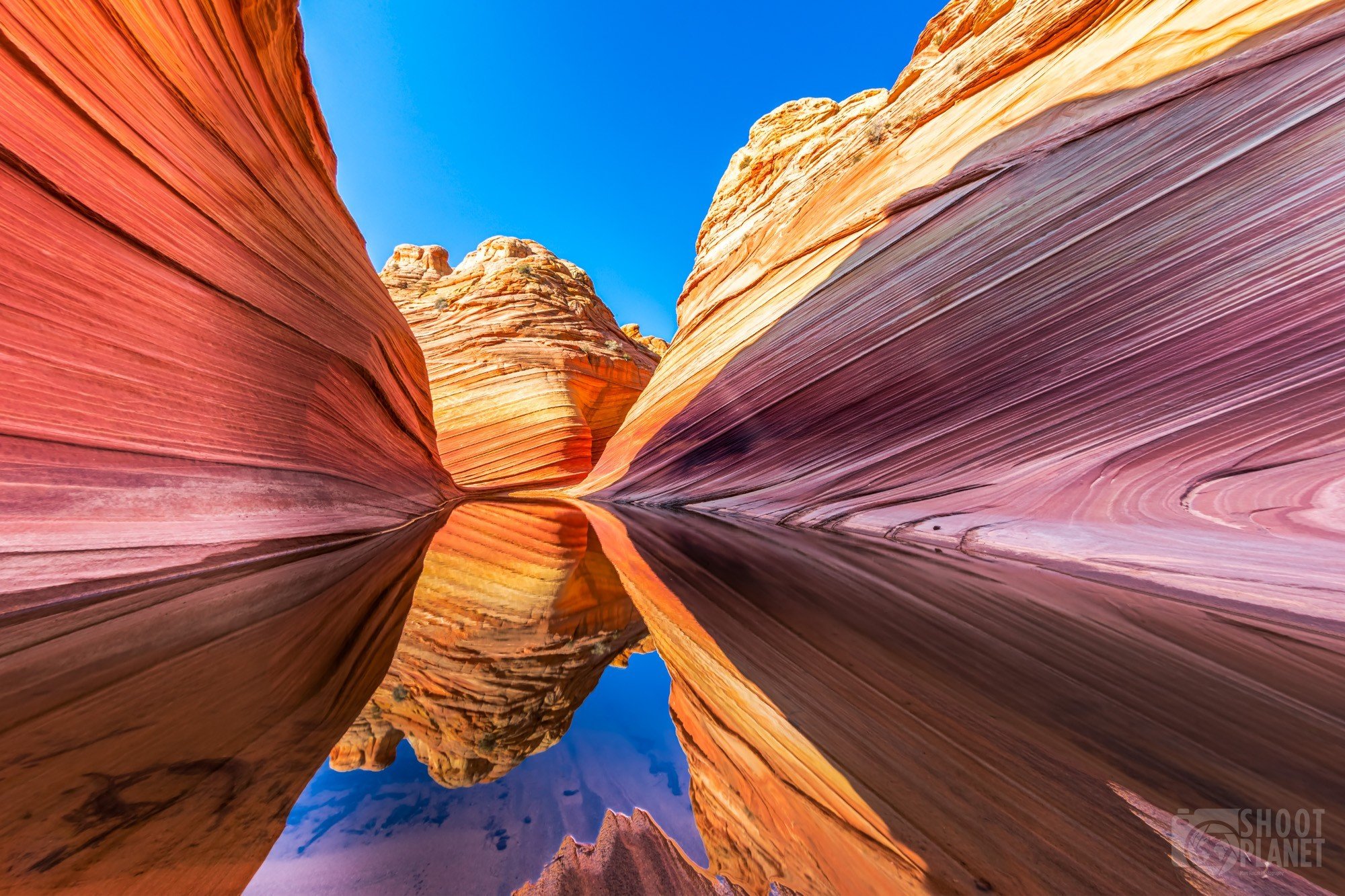
The Wave, nestled in the Coyote Buttes area of the Paria Canyon-Vermilion Cliffs Wilderness in Arizona, USA, stands as a testament to the extraordinary artistry of nature. This mesmerizing sandstone formation has captivated visitors for years with its unique geological features, undulating patterns, and vibrant colors. The Wave’s allure lies not only in its visual beauty but also in the fascinating geological processes that shaped it over millions of years.
Formed through a complex interplay of erosion, deposition, and geological processes, the sandstone layers of The Wave showcase the remnants of ancient dunes that once dominated the landscape. The characteristic swirled patterns that give The Wave its name are a result of different mineral compositions within the rock and the intricate interaction of wind and water over vast periods of time. These forces have sculpted the sandstone into smooth, wavelike forms that seem to flow across the landscape, creating an otherworldly and almost hypnotic visual effect.
The formation is primarily composed of Navajo Sandstone, a geological layer that was deposited during the Jurassic period, approximately 190 million years ago. This soft and cross-bedded sandstone created an ideal canvas for the sculpting forces of nature. Over time, wind and water erosion carved away at the rock, revealing the stunning patterns and colors we see today. The vibrant hues of red, orange, yellow, and pink that streak through The Wave are the result of various minerals present in the sandstone, including iron oxides, manganese, and limonite.
Due to its delicate nature and the fragility of the sandstone formations, access to The Wave is limited and tightly regulated to preserve its pristine condition. The Bureau of Land Management, which oversees the area, grants only a limited number of permits daily through a lottery system. This strict control ensures the protection and conservation of this natural masterpiece, allowing it to remain unspoiled for future generations to appreciate and study.
Visiting The Wave provides a unique opportunity to witness the intricate artistry of geological processes and immerse oneself in a breathtaking and otherworldly landscape. The journey to The Wave itself is an adventure, requiring a challenging 3-mile hike each way through unmarked desert terrain. This remote location and the physical effort required to reach it add to the sense of discovery and wonder that visitors experience upon arriving at the formation.
The Wave’s geological significance extends beyond its visual appeal. It serves as a valuable resource for scientists studying the processes of erosion and the formation of desert landscapes. The intricate patterns and layers visible in the rock provide insights into ancient environments and climate conditions, offering a window into Earth’s distant past.
2. Fairy Chimneys (Cappadocia, Turkey)
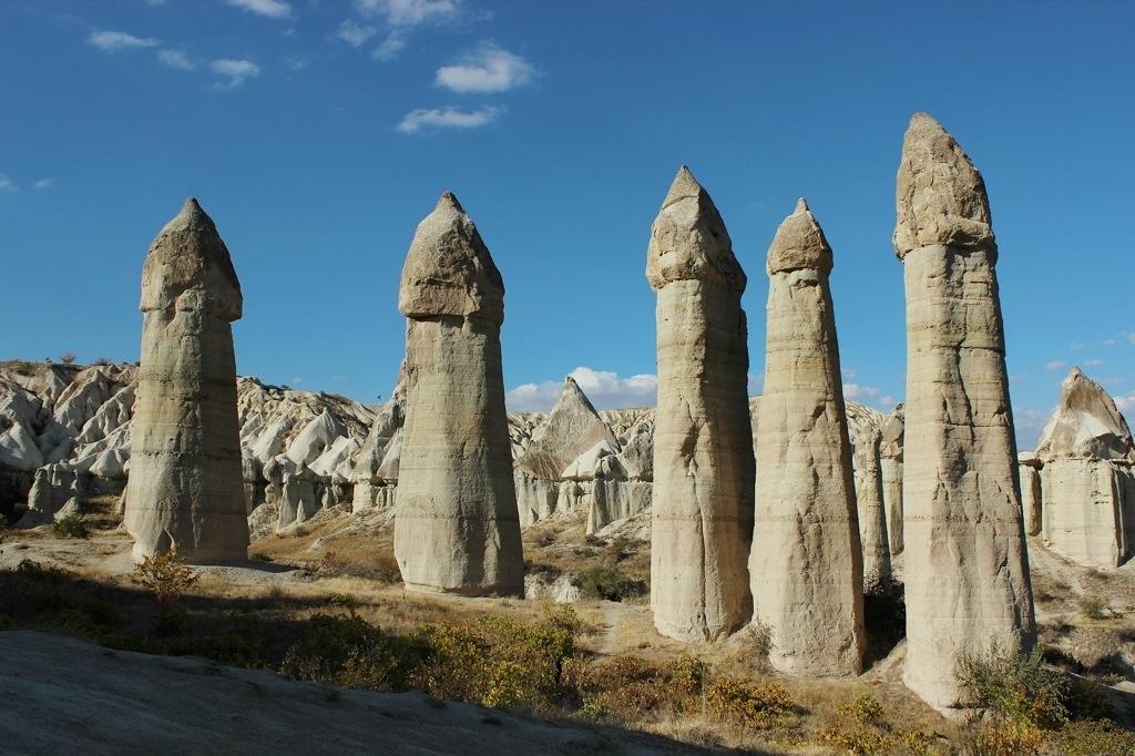
Cappadocia, a historical region in central Turkey, is renowned for its extraordinary landscape dotted with unique geological features known as fairy chimneys. These towering, cone-shaped rock formations, also called hoodoos, have captured the imagination of visitors for centuries and stand as a testament to the powerful forces of nature that have shaped this remarkable terrain over millions of years.
The formation of Cappadocia’s fairy chimneys began approximately 30 million years ago when volcanic eruptions blanketed the region with thick layers of ash, lava, and basalt. Over time, this volcanic material compacted and solidified into a soft, porous rock called tuff. The landscape was further shaped by the eruptions of three now-dormant volcanoes: Mount Erciyes, Mount Hasan, and Mount Melendiz. These eruptions added layers of harder, more resistant rock atop the softer tuff.
The unique appearance of the fairy chimneys is the result of differential erosion, a process where softer rock erodes more quickly than harder rock. Wind, rain, and temperature fluctuations gradually wore away the softer tuff, while the harder capstones remained largely intact, protecting the rock beneath them. This process created the distinctive mushroom-like shapes that characterize the fairy chimneys, with some reaching heights of up to 130 feet (40 meters).
The fairy chimneys of Cappadocia are not merely geological wonders; they have played a significant role in human history and culture. For centuries, people have carved dwellings, churches, and even entire underground cities into these soft rock formations. The region’s earliest inhabitants recognized the malleable nature of the tuff and its ability to provide natural insulation, keeping interiors cool in summer and warm in winter.
During the Byzantine period, Christian communities sought refuge in Cappadocia, fleeing persecution. They expanded existing cave dwellings and carved elaborate churches adorned with vibrant frescoes, many of which still survive today. The Göreme Open-Air Museum, a UNESCO World Heritage site, showcases some of the most impressive examples of these rock-cut churches and monastic complexes.
In modern times, Cappadocia has become a popular tourist destination, offering visitors a unique blend of natural beauty, historical significance, and cultural experiences. Many of the ancient cave dwellings have been converted into boutique hotels, allowing guests to experience living within these geological marvels. Hot air balloon rides over the landscape have become iconic, providing breathtaking aerial views of the fairy chimneys and the surrounding valleys.
The region’s unique geology continues to fascinate scientists and geologists, who study the formation processes and the ongoing erosion of the fairy chimneys. Conservation efforts are in place to protect these fragile formations from the impacts of tourism and natural weathering, ensuring that future generations can continue to marvel at this extraordinary landscape.
As visitors explore the winding valleys and climb to panoramic viewpoints, they are transported to a landscape that seems almost otherworldly. The fairy chimneys of Cappadocia stand as a reminder of the incredible diversity of our planet’s geological features and the enduring relationship between human civilization and the natural world.
3. Mushroom Rock State Park (Kansas, USA)
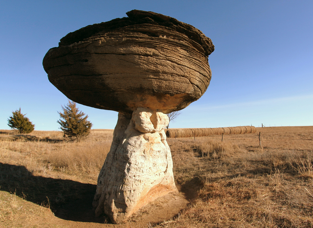
Mushroom Rock State Park, located in the heart of Kansas, USA, is a geological wonder that showcases nature’s artistic prowess through its distinctive mushroom-shaped rock formations. This small but captivating park, spanning just five acres, is home to some of the most unique sandstone concretions in the world, drawing visitors from far and wide to witness its peculiar beauty.
The park’s iconic mushroom rocks are the result of millions of years of geological processes, primarily erosion and weathering. These formations began their journey during the Cretaceous period, approximately 100 million years ago, when much of Kansas was covered by a vast inland sea. Sediments deposited on the seafloor gradually compacted and cemented together, forming layers of Dakota sandstone. Within these layers, certain areas became more tightly cemented than others, creating harder, more resistant sections of rock.
As the sea retreated and the land was exposed, the forces of wind and water erosion went to work on the sandstone. Over millions of years, the softer, less cemented rock eroded more quickly than the harder sections, resulting in the distinctive mushroom shapes we see today. The ‘caps’ of these mushroom rocks are composed of the more resistant sandstone, while the ‘stems’ are made of the softer, more easily eroded material.
The park features several notable formations, including the famous “Mushroom Rock” itself, which stands about 27 feet (8.2 meters) tall. This impressive formation, along with its neighboring rocks, has become an iconic symbol of Kansas’s unique geological heritage. The rocks vary in size and shape, with some resembling traditional mushrooms, while others take on more abstract forms, sparking the imagination of visitors.
Mushroom Rock State Park holds significant historical and cultural value beyond its geological importance. Native American tribes have long revered these formations, considering them sacred sites. In the 19th century, the rocks served as landmarks for pioneers and settlers traveling along the Butterfield Overland Despatch trail, a stagecoach route that connected Atchison, Kansas, to Denver, Colorado.
Today, the park offers visitors a chance to explore these fascinating formations up close. A network of short trails winds through the park, allowing guests to view the rocks from various angles and appreciate their unique characteristics. Interpretive signs provide information about the geological processes that formed the rocks, as well as the area’s historical significance.
Despite its small size, Mushroom Rock State Park plays a crucial role in preserving a unique piece of Kansas’s natural heritage. The park is managed by the Kansas Department of Wildlife, Parks and Tourism, which works to protect these delicate formations from erosion and human impact. Visitors are encouraged to observe and photograph the rocks but are prohibited from climbing on them to prevent damage.
The park also serves as an important educational resource, offering insights into the geological processes that shape our planet. School groups and geology enthusiasts often visit to study the formations and learn about the region’s ancient history. The rocks provide a tangible link to Kansas’s prehistoric past, allowing visitors to connect with geological time scales that can otherwise be difficult to comprehend.
Mushroom Rock State Park is more than just a collection of oddly shaped rocks; it’s a testament to the power of natural forces and the incredible diversity of our planet’s landscapes. As visitors stand in awe of these peculiar formations, they are reminded of the vast spans of time and the complex processes that have shaped the earth beneath our feet. The park continues to inspire wonder and curiosity, inviting us to ponder the incredible stories written in stone across millions of years.
4. Monument Valley (Arizona/Utah, USA)
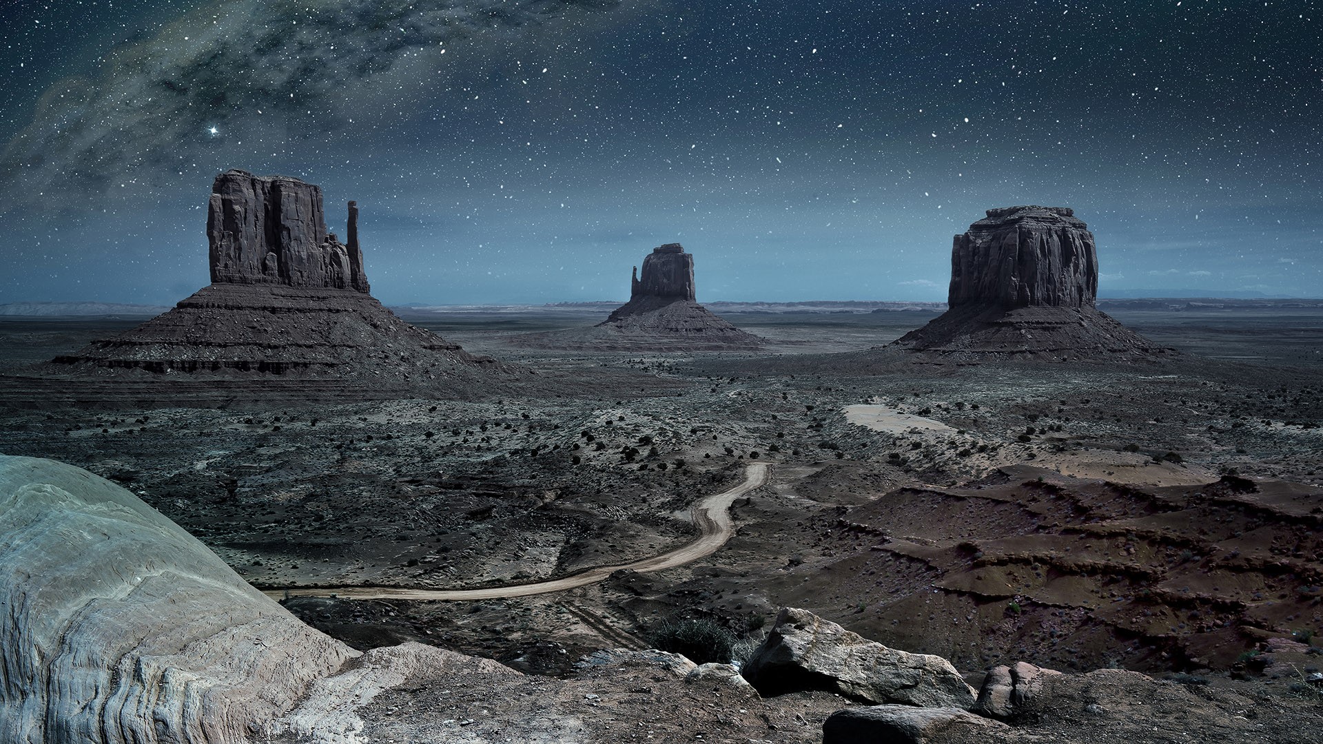
Monument Valley, straddling the border between Arizona and Utah in the southwestern United States, stands as one of the most iconic and recognizable landscapes in the world. This vast expanse of red desert punctuated by towering sandstone buttes has become synonymous with the American West, captivating visitors with its raw beauty and serving as a backdrop for countless films, photographs, and artistic works.
The geological story of Monument Valley began over 250 million years ago during the Permian period when the area was a flat basin near sea level. Over millions of years, layers of sediment, including sand, silt, and mud, were deposited in this basin. These layers were compressed and cemented over time, forming the sandstone and shale that make up the valley’s distinctive rock formations.
The most prominent layer visible in Monument Valley is the Permian Cutler Formation, which is responsible for the vibrant red color that characterizes the landscape. This red hue is due to the presence of iron oxide in the sandstone. Above this lies the Triassic Moenkopi Formation, which forms a darker, chocolate-brown layer often visible at the base of the buttes.
The sculpting of Monument Valley into its current form began around 70 million years ago when tectonic forces caused the Colorado Plateau to uplift. This uplift exposed the rock layers to the forces of erosion. Over millions of years, wind and water worked to wear away the softer rock, leaving behind the more resistant sandstone in the form of mesas, buttes, and spires that we see today.
Some of the most famous formations in Monument Valley include the Mittens, two buttes that resemble mittens with their thumbs facing inward; Merrick Butte, a solitary formation rising dramatically from the desert floor; and the Three Sisters, a group of spires that stand together like a family. Each of these formations tells a story of geological processes and the relentless forces of erosion that continue to shape the landscape.
Monument Valley holds deep cultural significance for the Navajo Nation, on whose land it resides. Known as Tsé Biiʼ Ndzisgaii in the Navajo language, meaning “valley of the rocks,” this area has been home to indigenous peoples for thousands of years. The Navajo have a profound spiritual connection to the land, with many of the rock formations featuring in their myths and legends.
Today, Monument Valley is part of the Navajo Nation’s tribal park system and is managed by the Navajo people. Visitors can explore the valley through a 17-mile scenic drive that winds among the major formations, offering breathtaking views and photo opportunities. Guided tours led by Navajo guides provide deeper insights into the geological, cultural, and historical significance of the area.
The valley’s unique beauty has made it a favorite location for filmmakers since the 1930s, with legendary director John Ford using it as the setting for several of his classic Westerns. This cinematic legacy has further cemented Monument Valley’s place in the popular imagination as the quintessential image of the American West.
Beyond its visual appeal, Monument Valley serves as an important site for geological study. Scientists continue to research the processes that formed and continue to shape the valley, gaining insights into the Earth’s history and the forces that mold our planet’s surface. The valley also provides valuable habitats for a variety of desert flora and fauna, adapted to survive in this harsh environment.
As visitors stand before the towering buttes of Monument Valley, they are confronted with a landscape that seems both timeless and ever-changing. The play of light and shadow across the red rocks throughout the day creates an ever-shifting panorama, reminding us of the dynamic nature of our planet. Monument Valley stands not just as a testament to the power of geological forces but also as a symbol of the enduring spirit of the American West and the deep connection between the land and its people.
5. Yehliu Geopark (Taiwan)
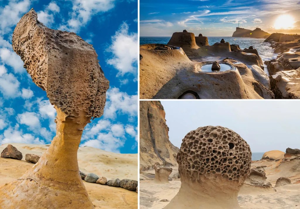
Yehliu Geopark, located on the northern coast of Taiwan in New Taipei City, is a remarkable testament to the sculpting power of natural forces. This coastal park, spanning approximately 1.7 kilometers, showcases an extraordinary collection of geological formations that have been shaped by the relentless action of wind, waves, and weathering over millions of years. The park’s unique landscape has made it one of Taiwan’s most popular tourist attractions, drawing visitors from around the world to marvel at its otherworldly rock formations.
The geological story of Yehliu Geopark begins approximately 20 to 30 million years ago during the Miocene epoch. At this time, the area was submerged beneath the sea, and layers of sediment were deposited on the ocean floor. Over millions of years, these sediments compacted and hardened into sedimentary rock, primarily composed of sandstone and mudstone. Tectonic activity gradually uplifted this seafloor, exposing it to the forces of erosion that would eventually sculpt the fascinating formations we see today.
The most famous and iconic formation in Yehliu Geopark is undoubtedly the “Queen’s Head,” a mushroom-shaped rock that bears a striking resemblance to the profile of a queen wearing a crown. This formation, like many others in the park, is the result of differential erosion, where softer rock erodes more quickly than harder rock. The “neck” of the Queen’s Head is composed of softer sandstone, while the “crown” is made of harder, more resistant rock. This delicate balance has created a formation that is both beautiful and fragile, with ongoing erosion threatening its long-term stability.
Beyond the Queen’s Head, Yehliu Geopark boasts a diverse array of fascinating rock formations, each with its own unique shape and story. These include the “Fairy’s Shoe,” a rock that resembles an oversized high-heeled shoe; the “Beehive” and “Ginger Rocks,” formations pockmarked with small holes created by salt weathering; and the “Sea Candles,” tall, cylindrical formations that resemble candles rising from the sea.
The park is also home to numerous “mushroom rocks,” formed through a similar process to the Queen’s Head, where a harder capstone protects the softer rock beneath from erosion. These formations come in various sizes and shapes, creating a surreal landscape that seems almost alien in its appearance.
The geological wonders of Yehliu are not limited to its rock formations. The park also features a wave-cut platform, a flat rocky surface created by wave erosion at the base of the sea cliff. This platform provides visitors with an opportunity to observe marine life in tidal pools and to witness the ongoing process of coastal erosion.
Yehliu Geopark serves as an important site for geological research and education. Scientists study the formations to gain insights into processes of erosion and weathering, while the park’s educational facilities and guided tours offer visitors a chance to learn about the geological forces that have shaped this unique landscape.
Conservation efforts are ongoing at Yehliu Geopark to protect its delicate formations from both natural erosion and human impact. The Queen’s Head, in particular, is closely monitored, with measures in place to prevent visitors from touching or climbing on the formation. Discussions have even been held about creating a replica of the Queen’s Head to preserve its likeness for future generations, as natural erosion continues to threaten its distinctive shape.
Visitors to Yehliu Geopark can explore the area via a network of walkways that wind through the formations, offering close-up views while protecting the delicate ecosystem. The park also features an indoor exhibition area that provides detailed information about the geological processes at work in the area and the history of its formation.
Yehliu Geopark stands as a testament to the incredible diversity of our planet’s geological features and the power of natural forces to create landscapes of breathtaking beauty. As visitors walk among its otherworldly rock formations, they are invited to ponder the vast spans of time and the complex processes that have shaped our Earth. The park not only offers a unique and memorable experience but also serves as a crucial reminder of the need to protect and preserve our planet’s natural wonders for future generations to study and admire.
6. White Desert (Egypt)
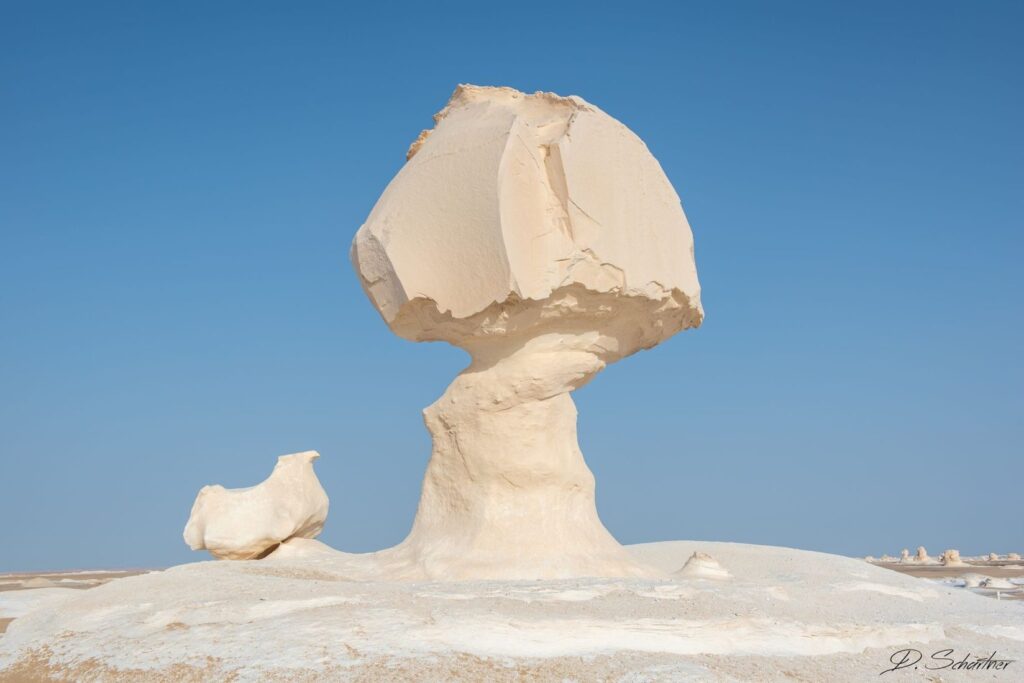
The White Desert, located in the Farafra depression of Egypt’s Western Desert, is a surreal and otherworldly landscape that captivates visitors with its stark beauty and unique geological formations. This natural wonder, spanning an area of approximately 300 square kilometers, stands in stark contrast to the typical image of Egypt’s golden sand dunes, offering instead a mesmerizing expanse of chalk-white rock formations that seem to have been sculpted by an otherworldly artist.
The geological story of the White Desert begins over 80 million years ago during the Late Cretaceous period when much of what is now Egypt was submerged beneath a vast shallow sea. During this time, the remains of marine organisms, particularly microscopic plankton, accumulated on the seafloor. Over millions of years, these remains were compressed and transformed into chalk, a soft limestone composed primarily of calcium carbonate.
As tectonic forces lifted the region above sea level, the chalk deposits were exposed to the elements. The harsh desert environment, characterized by extreme temperature fluctuations, occasional rainfall, and relentless wind, began the process of erosion that would ultimately shape the White Desert into its current form. The softer parts of the chalk eroded more quickly than the harder sections, resulting in the creation of the bizarre and beautiful shapes we see today.
The most striking features of the White Desert are its chalk rock formations, which take on a variety of shapes that spark the imagination of visitors. Many of these formations resemble familiar objects or creatures, leading to names such as “the chicken and the tree,” “the rabbit,” and “the mushroom.” The most famous of these is perhaps “the ice cream cone,” a large, conical formation that seems to defy gravity.
The brilliant white color of these formations is due to their composition of calcium carbonate. This whiteness is particularly striking at dawn and dusk when the low angle of the sun casts long shadows and bathes the desert in golden light, creating a landscape of unparalleled beauty. Under the light of a full moon, the White Desert takes on an even more ethereal quality, with the chalk formations seeming to glow in the darkness.
While the white chalk formations are the most prominent feature, the White Desert also contains areas of yellow limestone and brown sandstone, adding subtle color variations to the landscape. Occasional black dolerite deposits, remnants of volcanic activity, provide stark contrast to the prevailing whiteness.
The White Desert is not just a geological wonder; it’s also home to a variety of desert flora and fauna that have adapted to this harsh environment. Desert foxes, gazelles, and various species of birds can sometimes be spotted in the area. The desert is also of interest to paleontologists, as fossils of sea urchins, shellfish, and even early whales have been found here, providing evidence of the area’s marine past.
For visitors, the White Desert offers a unique and unforgettable experience. Many choose to explore the area on guided tours, which often include overnight camping under the stars. This allows visitors to witness the changing colors of the desert at sunset and sunrise, and to experience the profound silence and vastness of the desert night.
However, the fragile nature of the chalk formations presents conservation challenges. Wind erosion continues to shape the desert, and there are concerns about the impact of increased tourism on this delicate ecosystem. Efforts are being made to protect the area, including the designation of the White Desert as a national park in 2002.
The White Desert also holds cultural significance. It has been inhabited by humans for thousands of years, with evidence of Stone Age tools found in the area. Today, the desert is home to Bedouin communities who have adapted to life in this harsh environment and who often serve as guides for visitors.
This extraordinary landscape serves as a reminder of the incredible diversity of our planet’s geological features and the power of natural forces to create scenes of breathtaking beauty. The White Desert stands as a testament to the slow, patient work of erosion and the ever-changing nature of our Earth’s surface. As visitors wander among its ethereal formations, they are transported to a world that seems almost alien, yet is very much a part of our planet’s rich geological tapestry.
7. Shiprock (New Mexico, USA)
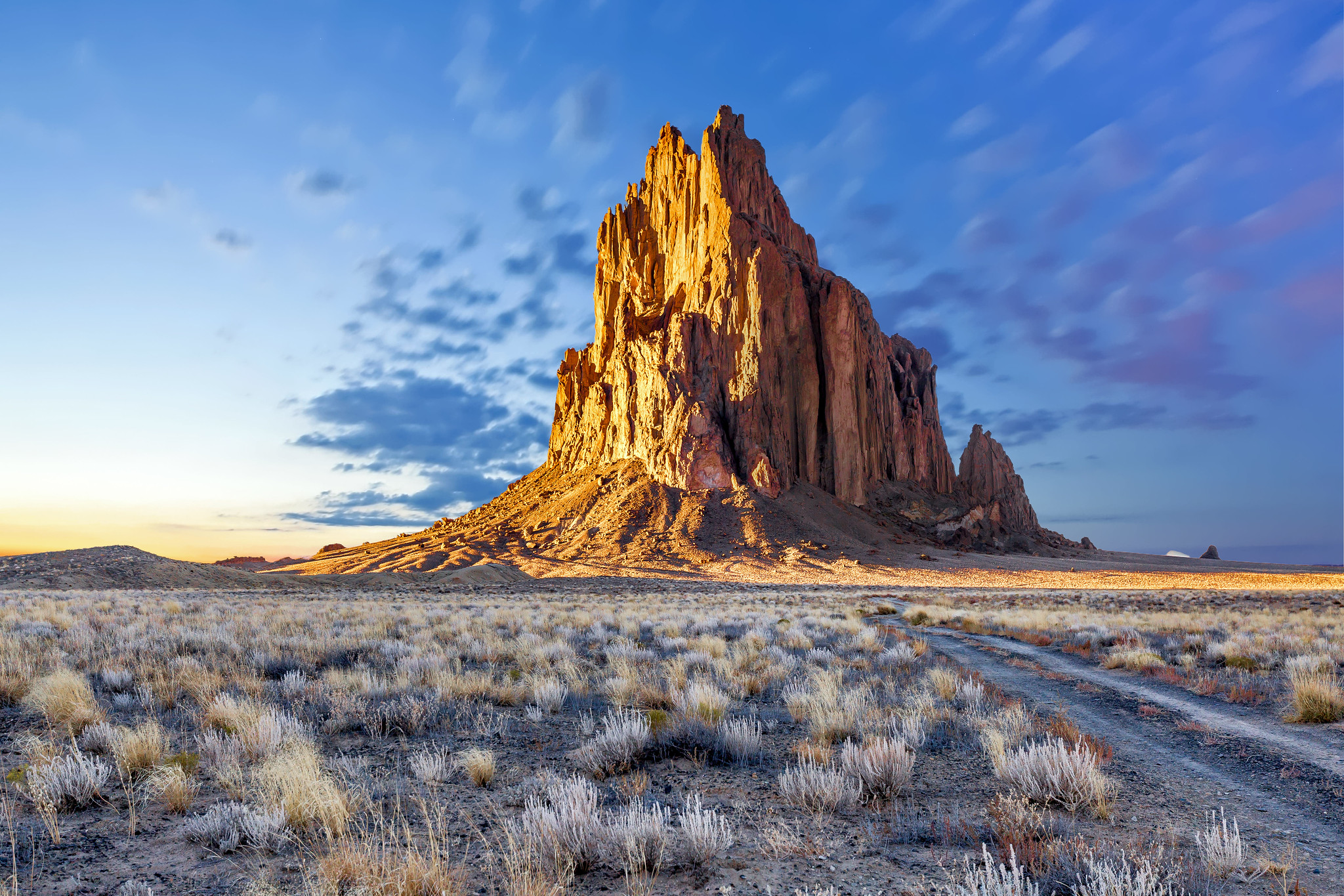
Shiprock, known as Tsé Bitʼaʼí or “rock with wings” in the Navajo language, is a towering and majestic rock formation that rises dramatically from the high desert plain of the Navajo Nation in northwestern New Mexico, USA. This iconic landmark, visible for miles in all directions, stands as a testament to the region’s volcanic past and holds deep cultural and spiritual significance for the Navajo people.
Rising to a height of 7,177 feet (2,188 meters) above sea level, with a prominence of about 1,583 feet (482 meters) from the surrounding desert floor, Shiprock is a striking geological feature that has captivated the imagination of people for centuries. Its distinctive shape, resembling a large ship with sails, is what gave it its English name when it was first documented by Anglo-Americans in the 1870s.
The geological story of Shiprock begins approximately 27 million years ago during a period of intense volcanic activity in the region. Shiprock is the eroded remnant of the throat of a volcano, a formation known as a volcanic plug or volcanic neck. It was formed when magma hardened within the vent of an active volcano. Over millions of years, the softer surrounding rock eroded away, leaving behind the more resistant igneous rock that forms Shiprock.
Geologically, Shiprock is composed primarily of fractured volcanic breccia and minette, a type of potassium-rich intrusive rock. The main formation is surrounded by a series of radiating dikes, long walls of igneous rock that were formed when magma intruded into cracks in the surrounding sedimentary rocks. These dikes, some of which extend for several miles, create a striking pattern when viewed from above.
The formation’s unique geology has made it a subject of study for geologists seeking to understand volcanic processes and the geological history of the American Southwest. Its distinctive shape and isolated position on the desert plain have also made it a popular subject for photographers and artists.
For the Navajo people, Shiprock holds profound cultural and spiritual significance. According to Navajo legend, the rock was once a great bird that transported their ancestors to the desert southwest. The Navajo name, Tsé Bitʼaʼí, translates to “rock with wings” or “winged rock,” reflecting this belief. The formation plays a central role in many Navajo stories and ceremonies, and is considered a sacred site.
Due to its sacred status and the dangerous nature of its sheer cliffs, climbing Shiprock has been banned since 1970. The Navajo Nation prohibits hiking and climbing on the formation or even approaching it closely without permission, in order to preserve its spiritual integrity and natural state.
Despite these restrictions, Shiprock remains a powerful draw for visitors who come to admire its imposing presence from a distance. The formation is particularly stunning at sunrise and sunset when the changing light paints its rugged surface in a palette of reds, oranges, and purples.
Shiprock’s commanding presence on the landscape has made it a landmark for travelers for centuries. In modern times, it has become an iconic symbol of the American Southwest, featured in numerous films, photographs, and works of art. Its distinctive silhouette is instantly recognizable and has come to represent the rugged beauty of the desert Southwest.
The area surrounding Shiprock also holds geological and archaeological interest. The desert plain around the formation is dotted with volcanic dikes and smaller rock formations, offering insights into the region’s volcanic history. Archaeological evidence suggests human habitation in the area dating back thousands of years, with ancient Puebloan sites found in the vicinity.
Shiprock serves as more than just a geological wonder or a sacred site; it’s a powerful reminder of the forces that have shaped our planet and the deep connections between the land and its people. As it stands sentinel over the desert landscape, Shiprock continues to inspire awe, spark curiosity, and invite contemplation of the vast scales of geological time and the enduring power of natural forces.
In a world increasingly dominated by human-made structures, Shiprock stands as a monumental natural landmark, a bridge between the ancient geological processes that shaped our planet and the cultural heritage of the people who have long called this rugged landscape home. Its continued preservation ensures that future generations will have the opportunity to marvel at its majesty and ponder the incredible forces that brought it into being.
8. Tsingy de Bemaraha (Madagascar)

The Tsingy de Bemaraha National Park, located in western Madagascar, is home to one of the most extraordinary and unique landscapes on Earth. The word “tsingy” in Malagasy means “where one cannot walk barefoot,” aptly describing the razor-sharp limestone formations that dominate this otherworldly terrain. This UNESCO World Heritage Site, covering an area of 152,000 hectares, showcases a geological wonder that has captivated scientists, adventurers, and nature enthusiasts alike.
The formation of the Tsingy began approximately 200 million years ago during the Jurassic period when the region was submerged beneath a vast tropical sea. Over millions of years, the remains of marine organisms accumulated on the seafloor, gradually compressing into thick layers of limestone. As tectonic forces lifted the area above sea level, the exposed limestone became subject to erosion by rainfall and groundwater.
The unique karst topography of the Tsingy is the result of a process called dissolution, where slightly acidic rainwater slowly dissolves the limestone. Over time, this process carved deep crevices and caverns into the rock, creating a vast network of underground drainage systems. As surface erosion continued, the harder, less soluble portions of the limestone remained, forming the iconic needle-like spires that characterize the Tsingy landscape.
These limestone needles can reach heights of up to 70 meters, creating a stone forest that stretches as far as the eye can see. The formations are incredibly sharp, with edges that can easily cut through equipment and skin, making exploration challenging and dangerous. The landscape is a maze of deep canyons, caves, and precarious rock bridges, presenting a formidable obstacle to both humans and wildlife.
Despite its harsh appearance, the Tsingy de Bemaraha is home to a surprisingly diverse ecosystem. The complex topography has created a variety of microclimates, allowing for the evolution of unique and specialized flora and fauna. Many species found here are endemic to Madagascar, and some are found nowhere else but in this specific region.
The park is home to 11 species of lemurs, including the rare all-white Decken’s sifaka and the vulnerable Sambirano lesser bamboo lemur. The Tsingy also provides habitat for over 100 bird species, 45 reptile and amphibian species, and a variety of bats that roost in the numerous caves. Plant life is equally diverse, with many species adapted to grow in the crevices and on the surfaces of the limestone formations.
Exploring the Tsingy de Bemaraha is a challenging but rewarding experience. A system of walkways, ladders, and bridges has been constructed to allow visitors to navigate through parts of this stone labyrinth safely. These pathways offer breathtaking views of the landscape and provide opportunities to observe the unique wildlife that has adapted to this extreme environment.
The Tsingy also holds significant cultural importance for the local Malagasy people. The area has been inhabited for centuries, and ancient burial sites have been discovered within the caves of the Tsingy. Local communities have developed traditional practices and beliefs associated with this unique landscape, adding a rich cultural dimension to its natural wonders.
Conservation of the Tsingy de Bemaraha presents unique challenges. The fragile limestone formations are susceptible to erosion, and increased tourism could potentially accelerate this process. Additionally, the isolation that has allowed for the evolution of unique species also makes them vulnerable to environmental changes. Efforts are ongoing to balance the preservation of this unique ecosystem with sustainable tourism and the needs of local communities.
Scientific research in the Tsingy continues to yield new discoveries. The complex cave systems beneath the surface are of particular interest to speleologists and biologists, who continue to find new species in these underground habitats. The Tsingy also provides valuable insights into geological processes and the effects of long-term erosion on limestone landscapes.
The Tsingy de Bemaraha stands as a testament to the incredible diversity of our planet’s landscapes and the power of geological processes to create environments of breathtaking beauty and complexity. It reminds us of the intricate connections between geology, climate, and biology, and the importance of preserving these unique ecosystems for future generations to study and admire.
As visitors navigate the precarious pathways through this stone forest, they are transported to a world that seems almost alien, yet is very much a part of our planet’s natural heritage. The Tsingy de Bemaraha continues to inspire awe, challenge our understanding of extreme environments, and underscore the importance of conservation efforts in protecting the world’s most unique and fragile ecosystems.
9. Bisti/De-Na-Zin Wilderness (New Mexico, USA)
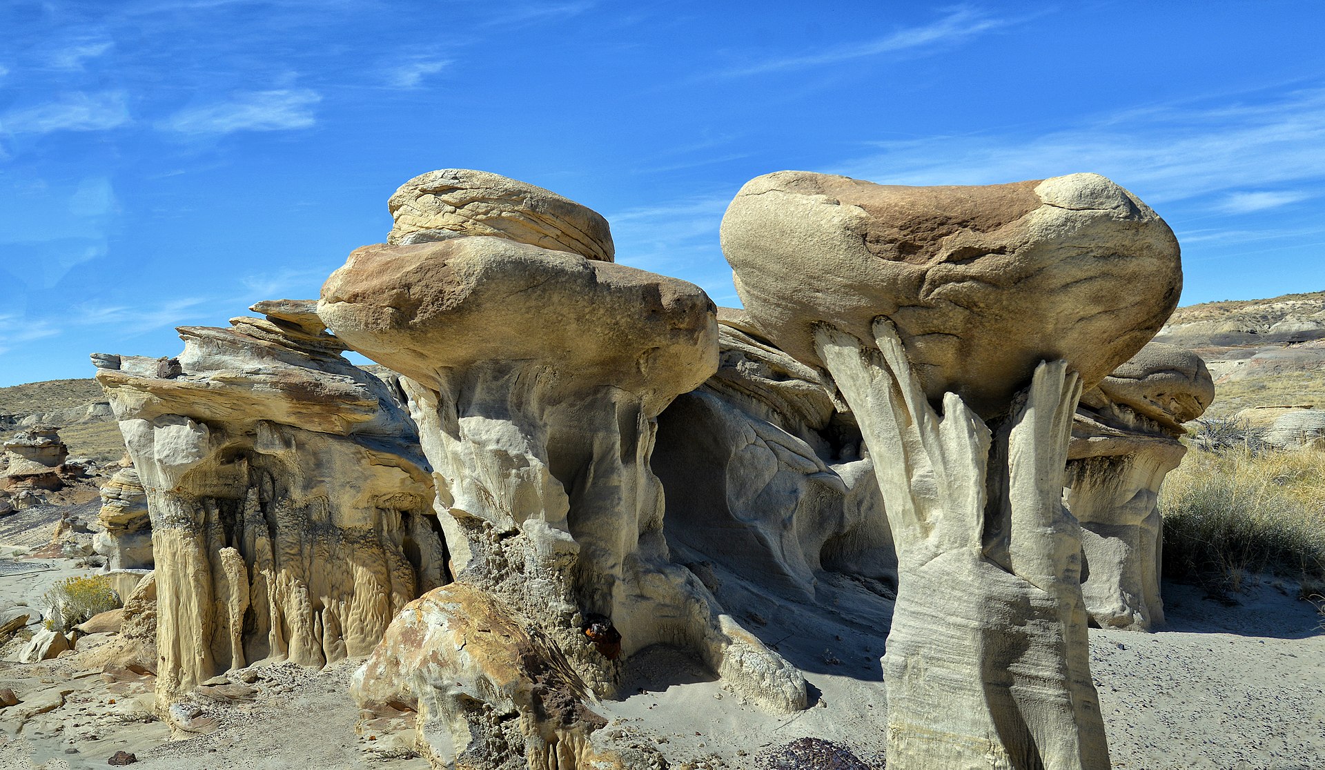
The Bisti/De-Na-Zin Wilderness, located in the high desert of northwestern New Mexico, USA, is a surreal and otherworldly landscape that seems more like a scene from a distant planet than a part of Earth. This remote area, spanning approximately 45,000 acres, is renowned for its bizarre rock formations, colorful badlands, and fossil-rich terrain that offers visitors a glimpse into both geological history and the power of erosion to sculpt incredible natural artworks.
The name “Bisti” (pronounced Bis-tie) is derived from the Navajo language and means “among the adobe formations,” while “De-Na-Zin” (deh-nah-zin) translates to “cranes” or “standing crane.” These names reflect both the area’s distinctive landscape and its cultural significance to the Navajo people who have inhabited the region for centuries.
The geological story of the Bisti/De-Na-Zin Wilderness begins approximately 70 million years ago during the Late Cretaceous period. At that time, the area was part of an ancient coastline bordering a shallow sea that covered much of what is now the southwestern United States. Over millions of years, layers of sediment, including sand, mud, and organic matter from decaying plants and animals, were deposited in this coastal environment.
As the sea retreated and the land uplifted, these sedimentary layers were exposed to the elements. The harsh desert environment, characterized by wind, sporadic but intense rainfall, and extreme temperature fluctuations, began the process of erosion that would ultimately shape the wilderness into its current form. The softer layers eroded more quickly than the harder ones, resulting in the creation of the bizarre and beautiful shapes we see today.
The most distinctive features of the Bisti/De-Na-Zin Wilderness are its hoodoos – tall, thin spires of rock that protrude from the bottom of arid basins. These hoodoos, often topped with harder, more resistant caps, come in a variety of shapes and sizes, some resembling mushrooms, others looking like alien creatures or abstract sculptures. The colorful layers visible in these formations provide a vivid record of the area’s geological history, with each layer representing a different period of deposition.
In addition to the hoodoos, the wilderness area features a variety of other fascinating geological formations. These include badlands – areas of soft sedimentary rock and clay that have been extensively eroded by wind and water; clinker – a natural glass formed when underground coal seams catch fire and bake the surrounding rock; and petrified wood – the remains of ancient forests that have been turned to stone through a process of mineral replacement.
The Bisti/De-Na-Zin Wilderness is also renowned for its paleontological significance. The area has yielded numerous important fossil discoveries, including dinosaur bones, eggs, and tracks. One of the most significant finds was the nearly complete skeleton of the Bisti Beast (Bistahieversor sealeyi), a tyrannosauroid dinosaur that lived approximately 74 million years ago. These fossils provide valuable insights into the ecosystem that existed here during the Late Cretaceous period.
Exploring the Bisti/De-Na-Zin Wilderness is a unique experience that requires careful preparation. The area is remote and undeveloped, with no marked trails, facilities, or sources of water. Visitors must be self-reliant and well-prepared for the harsh desert environment. However, for those who venture into this alien landscape, the rewards are immense. The ever-changing play of light and shadow across the bizarre rock formations creates an ever-shifting panorama of colors and shapes that seem to defy reality.
The wilderness area is particularly popular among photographers, who come to capture the otherworldly beauty of the landscape. The formations are especially stunning at sunrise and sunset when the low angle of the sun accentuates the textures and colors of the rocks.
Conservation efforts in the Bisti/De-Na-Zin Wilderness focus on preserving its unique geological features and paleontological resources while allowing for responsible public access. The area was designated as a wilderness in 1984, providing it with the highest level of protection available for public lands in the United States.
The Bisti/De-Na-Zin Wilderness serves as a living laboratory for geologists, paleontologists, and ecologists. Its exposed rock layers and well-preserved fossils provide valuable information about past environments and the evolution of life on Earth. The area also offers insights into the processes of erosion and the long-term effects of climate change on arid landscapes.
As visitors wander through this surreal landscape, they are transported to a world that seems almost beyond imagination, yet is very much a part of our planet’s rich geological heritage. The Bisti/De-Na-Zin Wilderness stands as a testament to the incredible diversity of Earth’s landscapes and the power of natural forces to create scenes of breathtaking beauty and scientific importance.
10. Yardang National Geopark (China)
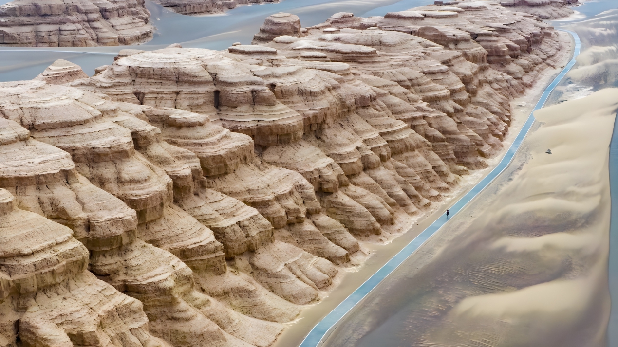
Yardang National Geopark, located in the Gobi Desert of Gansu Province, northwestern China, is a remarkable geological wonder that showcases the incredible sculpting power of wind erosion. Spanning an area of over 398 square kilometers, this unique landscape is characterized by its vast array of yardangs – streamlined, wind-carved ridges that create a surreal, almost otherworldly terrain often described as a “stone forest” or “ghost city.”
The term “yardang” comes from the Turkic word “yar,” meaning “steep bank,” and was first introduced to scientific literature by Swedish explorer Sven Hedin in the early 20th century. While yardangs can be found in various arid regions around the world, the Yardang National Geopark in China contains some of the most extensive and well-developed examples of this geological phenomenon.
The formation of the yardangs in this region began approximately 12 million years ago during the Miocene epoch. At that time, the area was covered by a vast lake. As the climate became increasingly arid, the lake dried up, exposing layers of sedimentary rock, primarily composed of sandstone and mudstone. Over millions of years, the relentless action of wind, carrying sand and dust particles, gradually eroded these rock layers, carving them into the distinctive shapes we see today.
The yardangs in the geopark take on a variety of forms, but they are typically characterized by their elongated, streamlined shapes with steep windward sides and gently sloping leeward sides. These formations can range in size from small ridges just a few meters high to massive structures towering over 30 meters tall and extending for hundreds of meters in length.
One of the most striking features of the Yardang National Geopark is the way these formations resemble various objects and creatures. Visitors often describe seeing shapes that remind them of ships, castles, animals, and even human faces. This tendency for the human mind to perceive familiar patterns in random shapes, known as pareidolia, adds an element of wonder and imagination to the experience of exploring the geopark.
The colors of the yardangs add to the surreal beauty of the landscape. The rocks display a range of hues from golden yellow to deep red, with variations depending on their mineral composition and the angle of the sunlight. This colorful palette, combined with the bizarre shapes of the formations, creates a landscape that seems almost painted or sculpted by an artist’s hand rather than by natural forces.
While wind is the primary sculptor of the yardangs, water also plays a role in shaping this landscape. Occasional rainstorms in the region can cause flash floods, which carve channels between the yardangs and contribute to their erosion. This interplay between wind and water erosion creates a complex and ever-evolving landscape.
The Yardang National Geopark is not just a geological wonder; it also holds significant historical and cultural value. The area has been inhabited by humans for thousands of years, and ancient rock carvings can be found in some parts of the park. The Silk Road, the ancient network of trade routes connecting East Asia and the Mediterranean world, passed near this region, and travelers would have used the distinctive yardang formations as landmarks.
Today, the Yardang National Geopark serves as an important site for geological research and education. Scientists study the formations to gain insights into processes of wind erosion and the geological history of the region. The park also offers visitors a unique opportunity to witness the power of natural forces to shape the Earth’s surface over vast periods of time.
Conservation efforts in the geopark focus on preserving the delicate yardang formations while allowing for sustainable tourism. Walkways and viewing platforms have been constructed to allow visitors to explore the area without damaging the fragile rock structures. Educational programs and guided tours provide information about the geological processes that formed the yardangs and the importance of preserving this unique landscape.
The Yardang National Geopark also plays a role in research related to Mars exploration. The landscape’s resemblance to certain Martian terrains has made it a valuable analog site for studying wind erosion processes on the Red Planet. Scientists use the geopark to test theories and equipment that might be used in future Mars missions.
As visitors wander through the stone labyrinths of the Yardang National Geopark, they are transported to a landscape that seems almost alien in its beauty and complexity. The yardangs stand as silent sentinels, bearing witness to millions of years of geological history and the incredible power of wind to shape our planet’s surface. This extraordinary geopark serves as a reminder of the diverse and often surprising ways in which natural forces can create landscapes of breathtaking beauty and scientific significance.