1. The Majestic Great Blue Hole of Belize
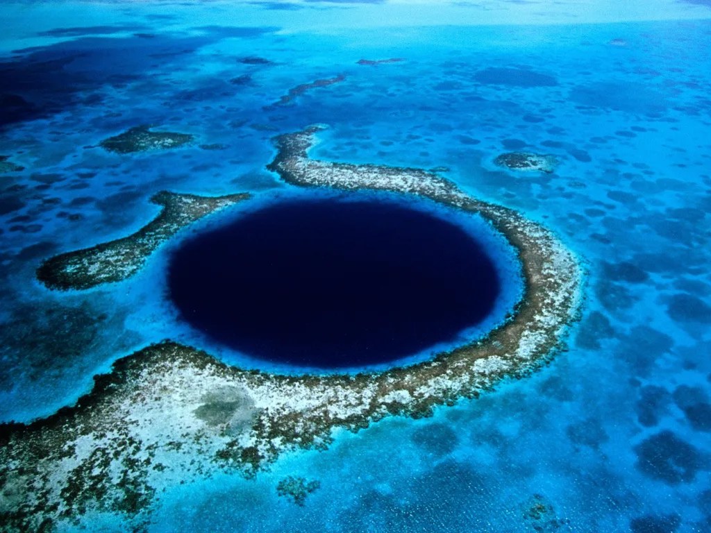
The Great Blue Hole in Belize stands as a testament to the awe-inspiring wonders that nature can create. This world-renowned underwater sinkhole has captivated the imagination of divers, nature enthusiasts, and explorers from every corner of the globe. Nestled off the coast of Belize, in the heart of the Lighthouse Reef Atoll, this geological marvel is a sight to behold. Its nearly perfect circular shape creates a stark contrast against the surrounding crystal-clear turquoise waters of the Caribbean Sea, appearing as a deep, dark indigo hole that seems to defy explanation. The Great Blue Hole’s impressive dimensions only add to its allure, boasting a diameter of approximately 300 meters (984 feet) and plunging to depths of about 124 meters (407 feet). These measurements make it not only visually striking but also one of the most iconic dive sites on the planet. The allure of the Great Blue Hole lies not just in its surface beauty but in the mesmerizing underwater world that awaits those brave enough to explore its depths. Divers who venture into this natural wonder are treated to a subaquatic landscape that seems almost alien in its beauty and complexity. The underwater environment is adorned with submerged stalactites, remnants of a time when sea levels were much lower and the hole was a dry cave system. These ancient formations serve as silent sentinels, bearing witness to the passage of time and the ever-changing face of our planet. In addition to these geological marvels, the Great Blue Hole is home to a diverse array of marine life, creating an ecosystem that is as vibrant as it is unique. From colorful tropical fish darting between coral formations to larger pelagic species that patrol the deeper waters, the biodiversity on display is truly remarkable. This combination of geological wonders and thriving marine life makes the Great Blue Hole an essential destination for those seeking an otherworldly and unforgettable underwater adventure. The experience of diving in the Great Blue Hole is often described as surreal, with many comparing it to floating in space. As divers descend into the depths, the water gradually darkens, creating an atmosphere of mystery and anticipation. The further one descends, the more the outside world seems to fade away, replaced by a serene underwater landscape that has remained largely unchanged for millennia. It’s an experience that leaves an indelible mark on all who undertake it, offering a profound connection with the natural world and a deeper appreciation for the hidden wonders that lie beneath the ocean’s surface.
2. Dean’s Blue Hole: The Bahamas’ Underwater Marvel
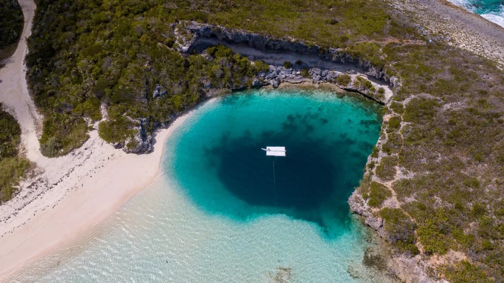
Dean’s Blue Hole in the Bahamas is a natural wonder that stands as a testament to the raw beauty and power of nature. Located on Long Island, this captivating marine sinkhole has earned its place as the world’s deepest known blue hole, plunging to astonishing depths of over 200 meters (660 feet). The sheer scale of this underwater chasm is difficult to comprehend, and it has become a mecca for free divers and underwater enthusiasts from around the globe. The allure of Dean’s Blue Hole lies not only in its record-breaking depth but also in the mesmerizing visual spectacle it creates. The hole’s enchanting sapphire waters create a stark contrast against the surrounding shallow, turquoise sea, forming a circular portal that seems to lead to another world entirely. This dramatic visual effect is further enhanced by the hole’s vertical walls, which drop off suddenly from the surrounding sandy shallows, creating an almost perfect cylindrical shape that descends into the depths below. The crystal-clear visibility of the water adds to the otherworldly atmosphere, allowing observers to peer into the abyss and marvel at the play of light and shadow on the underwater landscape. For free divers and underwater enthusiasts, Dean’s Blue Hole represents the ultimate challenge and a chance to push the boundaries of human endurance. The extraordinary depth of the hole, combined with its near-perfect conditions, has made it a popular site for free diving competitions and record attempts. Athletes from around the world gather here to test their limits, descending into the blue void with nothing but their breath and their determination. The hole’s unique characteristics create an ideal environment for these extreme sports, with its sheltered location providing calm waters and its depth offering a true test of skill and courage. Beyond its appeal to thrill-seekers, Dean’s Blue Hole is also a site of significant scientific interest. Its unique geological formation provides researchers with valuable insights into the processes that shape our planet’s underwater landscapes. The hole’s depth and structure offer clues about past sea levels and climate changes, making it a valuable resource for geologists and marine scientists. Additionally, the diverse ecosystem that has developed around and within the blue hole provides a rich field of study for marine biologists, offering glimpses into the adaptations and behaviors of species that thrive in this unique environment. For visitors who prefer to stay on the surface, Dean’s Blue Hole still offers an unforgettable experience. The surrounding area is a paradise of pristine beaches and clear waters, perfect for snorkeling, kayaking, or simply soaking in the breathtaking views. The hole’s reputation has also made it a popular destination for photographers and filmmakers, who come to capture its ethereal beauty and the play of light on its surface. Whether viewed from above or explored from within, Dean’s Blue Hole stands as a celebrated site that continues to inspire awe and wonder in all who encounter it, serving as a powerful reminder of the beauty and mystery that still exist in our world’s oceans.
3. Xiaozhai Heavenly Pit: China’s Geological Masterpiece
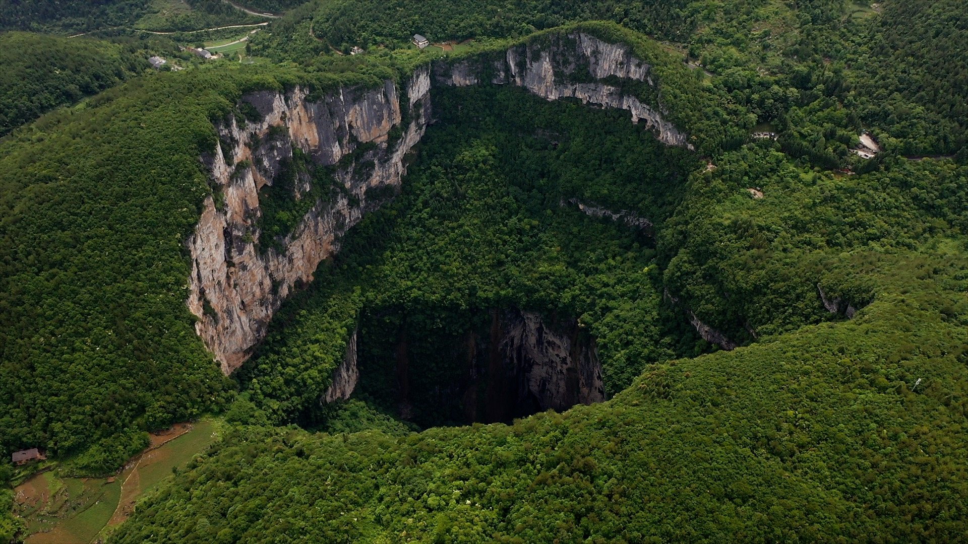
Xiaozhai Heavenly Pit in China is a geological masterpiece that stands as a testament to the raw power and beauty of nature’s forces. Located in Fengjie County, in the heart of China’s karst landscape, this massive sinkhole, also known as Xiaozhai Tiankeng, is an impressive natural phenomenon that leaves observers in awe of its vast dimensions and striking beauty. The sheer scale of Xiaozhai Heavenly Pit is difficult to comprehend, with a depth of approximately 511 meters (1,677 feet) and a diameter spanning over 511 meters as well. To put this into perspective, the pit is deep enough to swallow a skyscraper whole, making it one of the largest sinkholes in the world. The formation of this colossal pit is a result of millions of years of geological processes, primarily the dissolution of limestone bedrock by acidic water. Over time, this process created vast underground caverns, which eventually collapsed, forming the breathtaking chasm we see today. The pit’s name, “Heavenly Pit,” is apt, as standing at its rim feels like peering into another world entirely. The surrounding landscape adds to the pit’s allure, with lush vegetation clinging to steep limestone cliffs, creating a verdant frame for this natural wonder. The contrast between the lush greenery and the stark, vertical walls of the sinkhole creates a visual spectacle that is truly unforgettable. The unique karst topography of the region, characterized by its limestone bedrock and extensive cave systems, has made Xiaozhai Heavenly Pit a site of significant scientific interest. Geologists and researchers from around the world come to study its formation and the ongoing processes that continue to shape it. The pit offers valuable insights into the complex interplay between surface and underground water systems, as well as the long-term effects of erosion on karst landscapes. For adventurers and thrill-seekers, Xiaozhai Heavenly Pit presents an irresistible challenge. The pit has become a popular destination for extreme sports enthusiasts, particularly those interested in cave exploration and rappelling. The descent into the pit is not for the faint of heart, requiring specialized equipment and extensive training. Those who undertake this journey are rewarded with a unique perspective on the pit’s grandeur and the opportunity to explore its hidden depths. Despite its remote location, Xiaozhai Heavenly Pit has captured the imaginations of people around the world. Its existence serves as a powerful reminder of the hidden wonders that still exist on our planet, waiting to be discovered and appreciated. The pit’s vast scale and dramatic beauty have earned it a place of honor in the realm of geological wonders, standing alongside other natural marvels like the Grand Canyon or the Great Barrier Reef. For those fortunate enough to witness its grandeur firsthand, Xiaozhai Heavenly Pit offers a profound connection with the Earth’s geological processes and a humbling reminder of the immense forces that have shaped our planet over millions of years.
4. The Enigmatic Devil’s Sinkhole of Texas
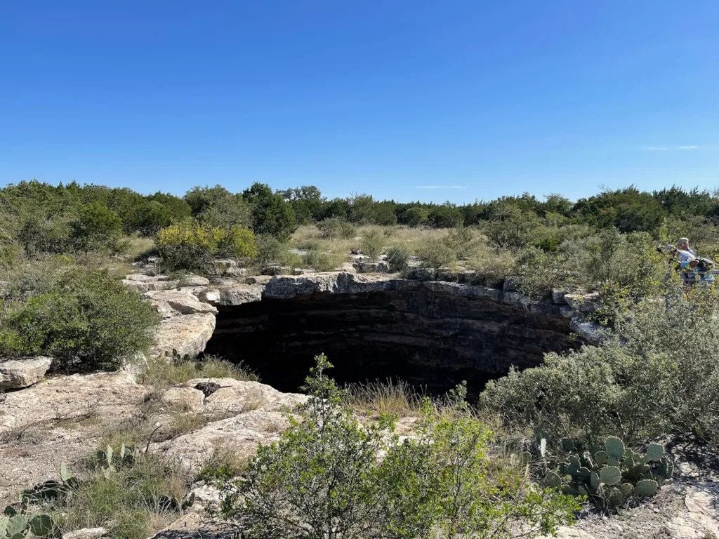
Devil’s Sinkhole in Texas, USA, stands as a testament to the intriguing geological formations found in the Lone Star State, captivating visitors with its mysterious allure and unique characteristics. Located in Edwards County, this vertical-walled cave sinkhole is a natural wonder that draws curious onlookers and researchers from far and wide. The sinkhole’s impressive depth and distinctive features make it not only a geological marvel but also a sanctuary for a massive colony of Mexican free-tailed bats, adding an extra layer of fascination to this already captivating site. The formation of Devil’s Sinkhole is a result of millions of years of geological processes, primarily the dissolution of limestone bedrock by acidic groundwater. Over time, this process created a vast underground cavern that eventually collapsed, forming the dramatic vertical shaft we see today. The sinkhole’s entrance is relatively small, measuring about 40 feet (12 meters) in diameter, but it quickly expands into a massive chamber below. The total depth of the sinkhole is approximately 350 feet (107 meters), with the main cavern reaching a width of about 320 feet (98 meters) at its widest point. This combination of a narrow entrance and vast interior creates a unique ecosystem and presents intriguing challenges for those who study it. One of the most remarkable aspects of Devil’s Sinkhole is its role as a habitat for a large colony of Mexican free-tailed bats. Each summer, the sinkhole becomes home to an estimated three million bats, making it one of the largest bat nurseries in the state. The sight of these bats emerging from the sinkhole at dusk is truly spectacular, creating a swirling vortex of wings that can last for hours. This natural phenomenon has become a major attraction, drawing wildlife enthusiasts and researchers alike to witness and study this remarkable display of nature. The presence of such a large bat population has significant ecological implications for the surrounding area. The bats play a crucial role in controlling insect populations, consuming vast quantities of moths and other agricultural pests each night. This natural pest control service provided by the bats is estimated to save local farmers millions of dollars annually in reduced crop damage and decreased need for chemical pesticides. Additionally, the bat guano deposited in the sinkhole over centuries has created a unique subterranean ecosystem, supporting a variety of specialized organisms adapted to life in this nutrient-rich environment. From a geological perspective, Devil’s Sinkhole offers valuable insights into the karst topography that characterizes much of central Texas. The sinkhole’s formation and ongoing evolution provide researchers with a living laboratory to study the complex interactions between surface and groundwater systems in limestone terrain. The sinkhole’s depth and structure also offer clues about past climate conditions and water table levels in the region, making it an important site for paleoclimatological research. Despite its scientific importance and natural beauty, access to Devil’s Sinkhole is carefully managed to protect both the fragile ecosystem and visitor safety. The Texas Parks and Wildlife Department oversees the site, offering guided tours that allow visitors to experience the sinkhole’s majesty while minimizing human impact on this delicate environment. These tours provide not only a chance to witness the bat emergence but also offer educational opportunities about the geology, ecology, and conservation efforts surrounding this unique natural wonder.
5. Mount Gambier: Australia’s Volcanic and Sinkhole Wonder
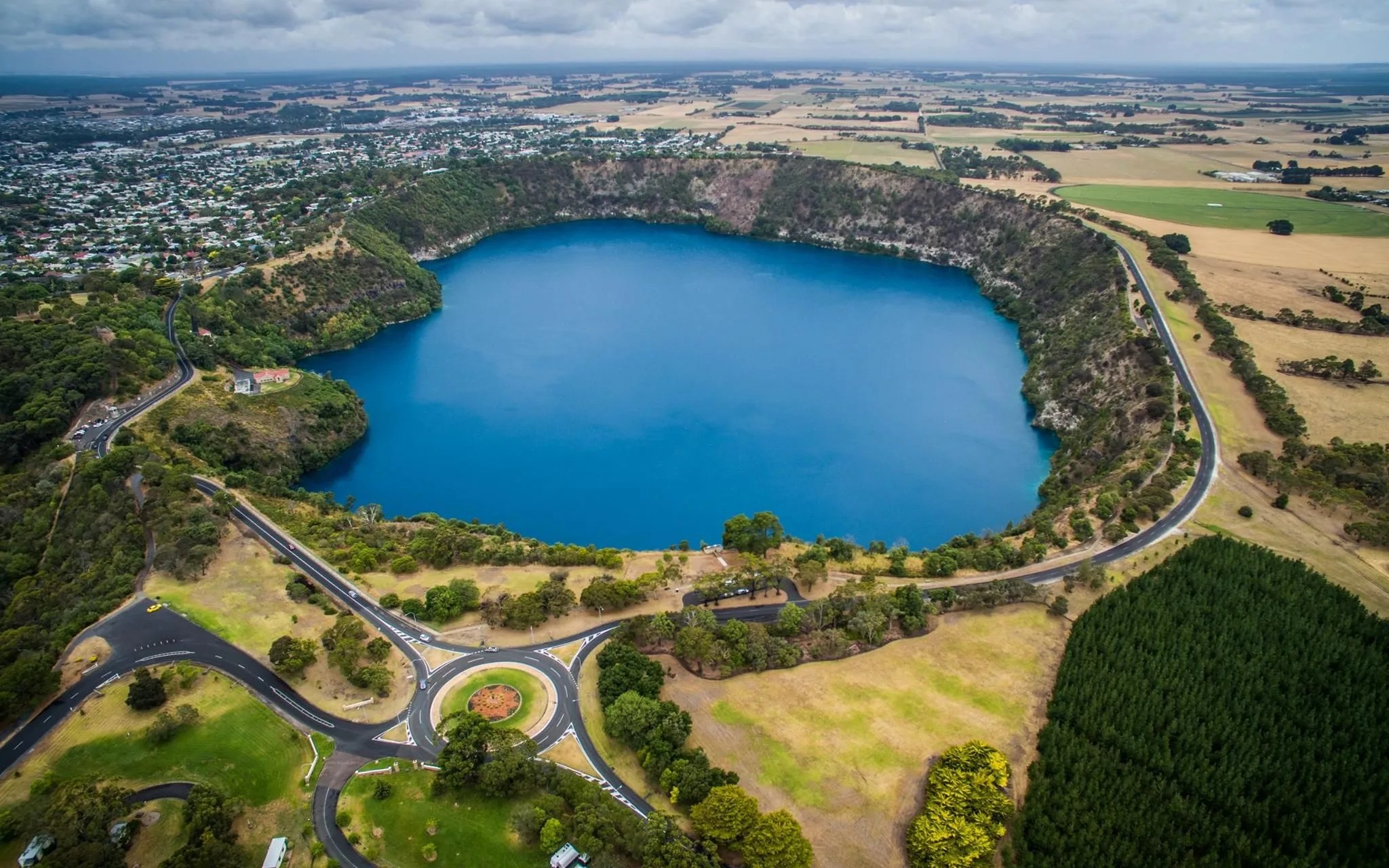
Mount Gambier in South Australia stands as a geological marvel, renowned for its unique combination of volcanic activity and sinkholes that have shaped the landscape over millions of years. This distinctive region, located in the state’s southeast, offers visitors a rare opportunity to witness the dramatic interplay between volcanic forces and the erosive power of water, resulting in a landscape that is both beautiful and scientifically fascinating. The area’s geological history is dominated by volcanic activity that occurred approximately 5,000 years ago, relatively recent in geological terms. This volcanic past has left an indelible mark on the region, creating a series of crater lakes and unique geological formations that continue to captivate visitors and researchers alike. Among the most famous features of Mount Gambier is the Blue Lake, a stunning crater lake that has become an iconic symbol of the region. The lake is renowned for its dramatic color change, shifting from a somber steel blue in winter to a vibrant cobalt blue in summer. This annual phenomenon, which typically occurs in November and lasts until late February, has puzzled scientists for years and continues to be a subject of ongoing research. The exact cause of this color change is still debated, with theories ranging from temperature-induced chemical reactions to changes in suspended particles in the water. Regardless of the scientific explanation, the sight of the Blue Lake in its full summer glory is truly breathtaking, drawing thousands of visitors each year to witness this natural spectacle. In addition to its volcanic features, Mount Gambier is also home to a number of remarkable sinkholes, further adding to its geological diversity. The most famous of these is the Umpherston Sinkhole, also known as the Sunken Garden. This once-hidden limestone cave has been transformed into a beautiful sunken garden, showcasing the potential for harmonious integration between natural geological features and human landscaping efforts. The sinkhole’s walls are adorned with cascading vines and lush plant life, creating a verdant oasis that seems to exist in a world of its own. Terraced gardens and viewing platforms allow visitors to descend into the sinkhole and experience its unique microclimate and tranquil atmosphere. The transformation of the Umpherston Sinkhole from a natural cavity to a cultivated garden began in 1886 when James Umpherston, a local settler, saw the potential in this collapsed limestone cave. His vision and efforts laid the foundation for what would become one of Mount Gambier’s most beloved attractions. The sinkhole’s history and development serve as a testament to the creative ways in which humans can interact with and enhance natural landscapes, creating spaces of beauty and tranquility that honor the underlying geological processes. Beyond these headline attractions, Mount Gambier and its surrounding areas offer a wealth of other geological wonders for visitors to explore. The region is dotted with numerous other sinkholes, caves, and underground water systems, many of which are accessible to the public through guided tours. These features not only provide recreational opportunities but also offer valuable insights into the complex hydrology of the area, showcasing the intricate network of underground water channels that have shaped the landscape over millennia. The juxtaposition of volcanic landscapes and sinkholes in Mount Gambier adds a distinctive charm to the region, drawing both geology enthusiasts and nature lovers to explore its picturesque surroundings. The area serves as a living laboratory for researchers studying the long-term effects of volcanic activity on landscape evolution and the ongoing processes of karst formation in limestone terrain. For visitors, Mount Gambier offers a unique opportunity to witness firsthand the dramatic geological forces that have shaped our planet, providing a tangible connection to the Earth’s dynamic past and ongoing geological processes.
6. The Enigmatic Red Lake of Croatia
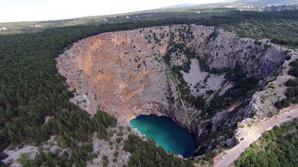
The Red Lake is renowned not only for its captivating beauty but also for its remarkable geological significance. Its unique formation offers researchers valuable insights into the complex karst systems that underlie much of the Dalmatian coast. The lake’s extreme depth and the surrounding cliffs provide a rare opportunity to study the vertical profile of karst formations, offering clues about the region’s geological history and the processes that continue to shape the landscape. The lake is also of great interest to hydrologists, as it offers a window into the interconnected relationship between surface and underground aquifer systems. The water level in the Red Lake fluctuates significantly throughout the year, rising during periods of heavy rainfall and receding during drier months. This fluctuation is indicative of the complex network of underground channels and caverns that connect the lake to other water bodies in the region, both above and below ground. Understanding these connections is crucial for managing water resources in an area where fresh water can be scarce, especially during the hot Mediterranean summers. For visitors, the Red Lake provides a serene and picturesque setting that seems almost otherworldly in its beauty. The surrounding landscape is equally impressive, with lush forests and rocky cliffs completing the enchanting tableau. The area around the lake offers numerous hiking trails that provide breathtaking views of the sinkhole and the surrounding countryside. These trails not only offer recreational opportunities but also allow visitors to gain a deeper appreciation for the unique geology of the region. From certain vantage points, one can observe the layers of rock exposed in the sinkhole walls, each stratum telling a part of the area’s geological story. Despite its allure, the Red Lake remains somewhat mysterious due to the challenges posed by its extreme depth and steep sides. Unlike its nearby sibling, the Blue Lake (Modro Jezero), which becomes accessible during dry periods, the Red Lake’s water level never drops low enough to allow easy access to its shores. This inaccessibility has helped preserve the lake’s pristine condition but has also limited scientific exploration of its depths. In recent years, however, advances in technology have allowed researchers to begin probing the lake’s secrets using remote sensing equipment and underwater drones. These studies are shedding new light on the lake’s underwater topography and the unique ecosystems that may have developed in its isolated waters. The Red Lake, with its stunning beauty and geological significance, stands as a testament to the raw power of nature and the ongoing processes that shape our planet. It serves as a reminder of the hidden wonders that exist beneath the Earth’s surface and the importance of preserving these natural treasures for future generations to study and admire. As research continues and our understanding of this remarkable formation grows, the Red Lake is likely to remain a source of fascination and wonder for scientists, nature enthusiasts, and casual visitors alike, cementing its place as one of Croatia’s most captivating natural landmarks.
7. The Twin Wonders: Sima Humboldt and Sima Martel of Venezuela
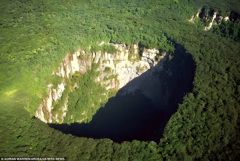
Sima Humboldt and Sima Martel, twin sinkholes located in the remote and rugged Chimantá Massif of Venezuela, are geological marvels that captivate with their awe-inspiring depth and isolation. These sinkholes, among the deepest in the world, stand as testament to the raw power of geological processes and the breathtaking beauty that can result from millions of years of erosion and collapse. Situated atop the Sarisariñama tepui, a table-top mountain in Bolívar State, these massive cavities in the Earth’s surface offer a unique glimpse into the pristine and remote natural landscapes of Venezuela, reminding us of the remarkable geological wonders that remain hidden in some of the world’s most inaccessible corners. Sima Humboldt, named after the renowned German explorer and naturalist Alexander von Humboldt, is the larger of the two sinkholes. It boasts a depth of approximately 314 meters (1,030 feet) and a diameter of about 352 meters (1,155 feet). Its sister sinkhole, Sima Martel, named after the French speleologist Édouard-Alfred Martel, is slightly smaller but no less impressive, with a depth of about 248 meters (814 feet) and a diameter of roughly 175 meters (574 feet). The sheer scale of these formations is difficult to comprehend, with each sinkhole large enough to swallow several city blocks whole. The formation of these massive sinkholes is the result of a complex interplay of geological processes over millions of years. The Chimantá Massif, like other tepuis in the region, is composed primarily of ancient sandstone and quartzite, rocks that are typically resistant to erosion. However, over time, water has seeped into cracks and fissures in the rock, gradually dissolving and eroding the underlying layers. This process, combined with the collapse of vast underground cave systems, eventually led to the formation of these enormous surface depressions. What makes Sima Humboldt and Sima Martel particularly fascinating is their isolated location and unique ecosystems. The sinkholes are surrounded by dense, virtually untouched rainforest, creating a stark contrast between the lush green vegetation and the dark, yawning chasms. At the bottom of each sinkhole, a unique microclimate has developed, fostering the growth of plant and animal species that may exist nowhere else on Earth. The bases of the sinkholes are covered in dense vegetation, creating the appearance of miniature forests nestled within the Earth. These isolated ecosystems, cut off from the surrounding environment for thousands of years, offer scientists a rare opportunity to study evolution and adaptation in extreme conditions. The challenging access to these sinkholes has both preserved their pristine state and limited scientific exploration. Reaching the Chimantá Massif requires a combination of helicopter transport and arduous trekking through dense jungle terrain. This isolation has helped protect the sinkholes and their surrounding ecosystems from human interference, but it has also made comprehensive scientific study a significant challenge. In recent years, however, advances in technology and increased interest in these geological wonders have led to more extensive exploration efforts. Researchers have begun to uncover the secrets hidden within these massive cavities, from unique plant and animal species to clues about the region’s geological history and climate changes over millennia. The existence of Sima Humboldt and Sima Martel serves as a powerful reminder of the vast areas of our planet that remain largely unexplored and the potential for new discoveries that still exist in the 21st century. These sinkholes, with their breathtaking dimensions and isolated ecosystems, continue to inspire awe and wonder in those who learn of their existence. They stand as monuments to the ongoing geological processes that shape our planet and the incredible biodiversity that can develop in even the most seemingly inhospitable environments. For adventurers, scientists, and nature enthusiasts alike, Sima Humboldt and Sima Martel represent the epitome of Earth’s hidden wonders, offering a glimpse into a world that seems almost alien in its beauty and complexity. As research continues and our understanding of these remarkable formations grows, they are likely to remain a source of fascination and inspiration, reminding us of the incredible diversity and beauty of our planet’s geological features.
8. The Engineering Marvel: Giant Glory Hole at Monticello Dam, California
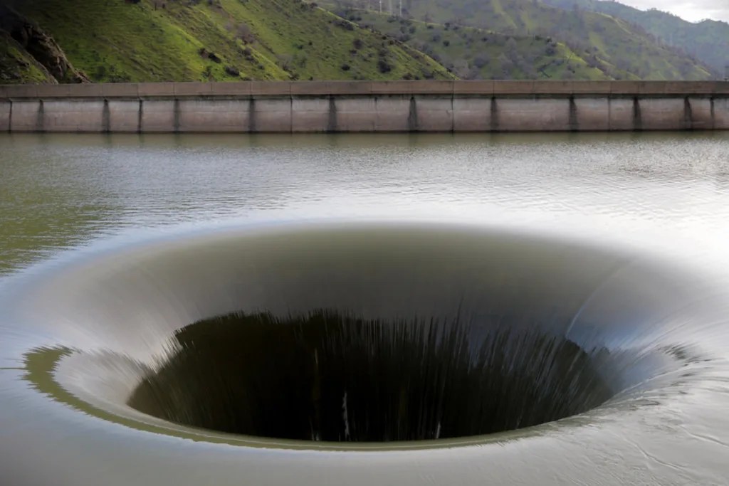
The Giant Glory Hole at the Monticello Dam in California, USA, is a man-made spectacle that showcases both engineering ingenuity and natural beauty. This immense spillway sinkhole, constructed to manage excess water in Lake Berryessa, presents a mesmerizing sight when the reservoir reaches full capacity and the dam must release water. Located in Napa County, California, the Monticello Dam was completed in 1957 as part of the Solano Project, aimed at providing water for irrigation and municipal use in the surrounding areas. The dam’s most distinctive feature, the Glory Hole spillway, has since become an iconic landmark and a testament to human engineering prowess. The circular hole, approximately 72 feet (22 meters) in diameter at its mouth, tapers down to a narrower exit pipe, creating a funnel-like structure that acts like a gigantic drain. When the water level in Lake Berryessa rises above 440 feet above sea level, it begins to spill into the Glory Hole, creating a mesmerizing vortex as water rushes into it. This spectacle draws visitors from far and wide, eager to witness the awesome power of water management in action. The engineering behind the Glory Hole is a marvel in itself. The spillway was designed to handle a maximum flow of 48,400 cubic feet per second, ensuring that even during periods of heavy rainfall or snowmelt, the dam can safely manage excess water without risking overtopping. The water that enters the Glory Hole drops about 200 feet straight down before being redirected horizontally through a 28-foot-diameter concrete pipe. This pipe runs about 700 feet, exiting at the base of the dam where the water rejoins Putah Creek. The design of the Glory Hole is not only functional but also aesthetically striking. When not in use, the circular opening creates a surreal sight, appearing like a portal to another dimension against the backdrop of the lake and surrounding hills. During dry periods, the exposed concrete structure becomes a canvas for light and shadow, creating captivating visual effects that have made it a popular subject for photographers and artists. When in operation, the Glory Hole transforms into a spectacle of nature harnessed by human engineering. The swirling vortex of water creates a hypnotic display, demonstrating the raw power of hydrodynamics on a massive scale. The sound of rushing water adds to the sensory experience, reinforcing the impression of nature’s might channeled through human design. While the Glory Hole is an impressive feat of engineering, it also serves as a stark reminder of the environmental challenges facing California. The spillway only comes into operation during periods of significant rainfall, which have become increasingly rare due to prolonged droughts in the region. In fact, between 2006 and 2017, the Glory Hole remained dry, highlighting the impact of changing climate patterns on water resources in the area. When it does operate, however, it becomes a symbol of abundance and relief for a region often plagued by water scarcity. The Glory Hole has also become an important part of the local ecosystem. During dry periods, birds have been known to nest in the exposed concrete structure. When water levels rise, fish are occasionally swept into the spillway, leading to concerns about their welfare. In response, wildlife officials have implemented measures to protect both the local fauna and curious humans, installing barriers and warning signs to prevent accidents. This engineered sinkhole is a testament to humanity’s ability to work in harmony with nature, offering a fascinating display of the power of water management and a unique attraction for those who come to witness its dramatic operation. It stands as a powerful symbol of the ongoing relationship between human needs, engineering capabilities, and the natural world, reminding us of the complex interplay between these elements in our modern world. As climate change continues to affect water patterns globally, structures like the Glory Hole at Monticello Dam will likely play an increasingly crucial role in water management strategies, making them not just marvels of engineering but essential components of our adaptation to a changing environment.
9. The Guatemala City Sinkhole: An Urban Geological Catastrophe
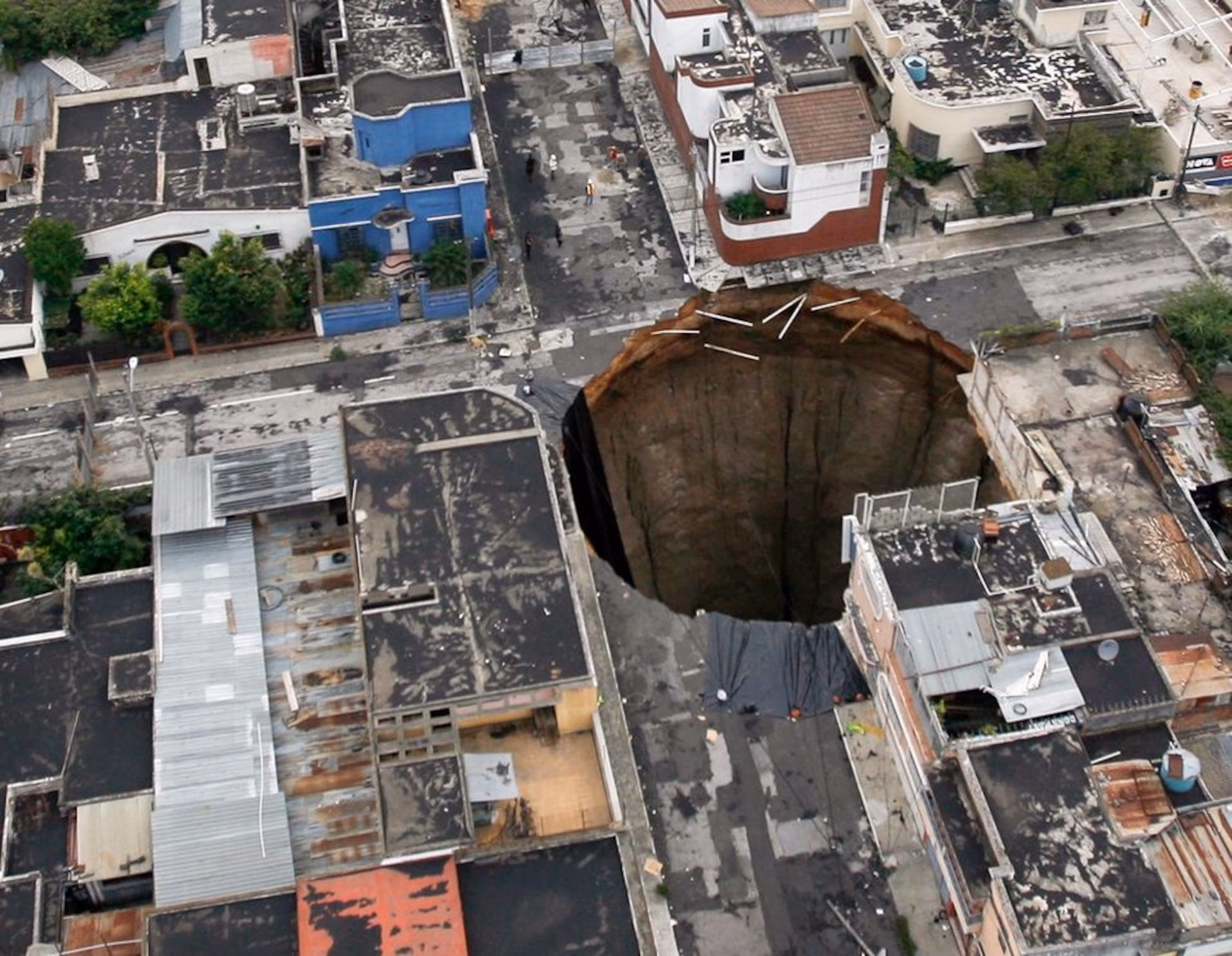
The Guatemala City Sinkhole, a sudden and astonishing geological event that occurred in 2010, captured the world’s attention due to its dramatic formation and the immediate impact it had on the urban landscape. Located in the heart of Guatemala City, this massive sinkhole, approximately 20 meters (66 feet) in diameter and more than 30 meters (98 feet) deep, seemingly appeared overnight after heavy rains and a ruptured sewage pipe softened the ground, causing the sudden and shocking collapse. This event served as a stark reminder of the vulnerabilities of urban infrastructure and the power of natural forces, leaving an indelible mark on the city’s landscape and reminding us of the unpredictable and dynamic nature of the Earth’s surface. The formation of the Guatemala City Sinkhole was a complex interplay of geological and human factors. The city is built upon a foundation of volcanic pumice fill, a material that is particularly susceptible to erosion and collapse when exposed to water. Years of inadequate urban planning and aging infrastructure had created a perfect storm of conditions that ultimately led to this catastrophic event. The heavy rains that preceded the collapse saturated the ground, while a ruptured sewage pipe further weakened the underlying soil structure. When the ground finally gave way, it did so with frightening speed and efficiency, swallowing an entire three-story building and claiming several lives in the process. The impact of the sinkhole on the local community was immediate and profound. The collapse forced the evacuation of hundreds of nearby residents and businesses, disrupting lives and livelihoods. The gaping hole in the middle of a densely populated urban area became a symbol of the city’s infrastructure challenges and the potential dangers lurking beneath the surface of many urban environments. In the aftermath of the collapse, geologists and engineers descended on the site to study the sinkhole and assess the risks of further collapses in the area. Their findings highlighted the urgent need for comprehensive geological surveys in urban areas, particularly those built on potentially unstable ground. The sinkhole also sparked a broader conversation about urban planning and infrastructure maintenance in cities around the world, particularly those in developing countries where rapid urbanization often outpaces the development of adequate infrastructure. The Guatemala City Sinkhole became a case study in the importance of understanding the geological foundations of urban areas and the potential risks associated with building on certain types of terrain. It underscored the need for rigorous geological assessments before urban development and the importance of ongoing monitoring and maintenance of underground infrastructure. In the years following the collapse, efforts were made to stabilize the area and prevent future sinkholes. This included extensive geological surveys, improvements to the city’s drainage and sewage systems, and the implementation of stricter building codes and urban planning regulations. However, the incident left a lasting impact on the psyche of the city’s residents, serving as a constant reminder of the hidden dangers that can lurk beneath our feet in urban environments. The Guatemala City Sinkhole also drew attention to the global issue of urban sinkholes, which have become increasingly common in cities around the world. From Florida to China, urban areas built on karst topography or other unstable geological formations face similar risks. The incident in Guatemala City served as a wake-up call for many urban planners and city officials, prompting increased attention to geological factors in urban development and infrastructure maintenance. In conclusion, the Guatemala City Sinkhole of 2010 stands as a dramatic example of the intersection between natural geological processes and human urban development. It highlights the importance of understanding and respecting the natural foundations upon which our cities are built, and the potential consequences of neglecting this crucial aspect of urban planning. As cities continue to grow and expand, often into areas with challenging geological conditions, the lessons learned from this event will remain relevant and important for urban planners, geologists, and city officials around the world.
10. Sotano de las Golondrinas: Mexico’s Vertical Cave of Wonders
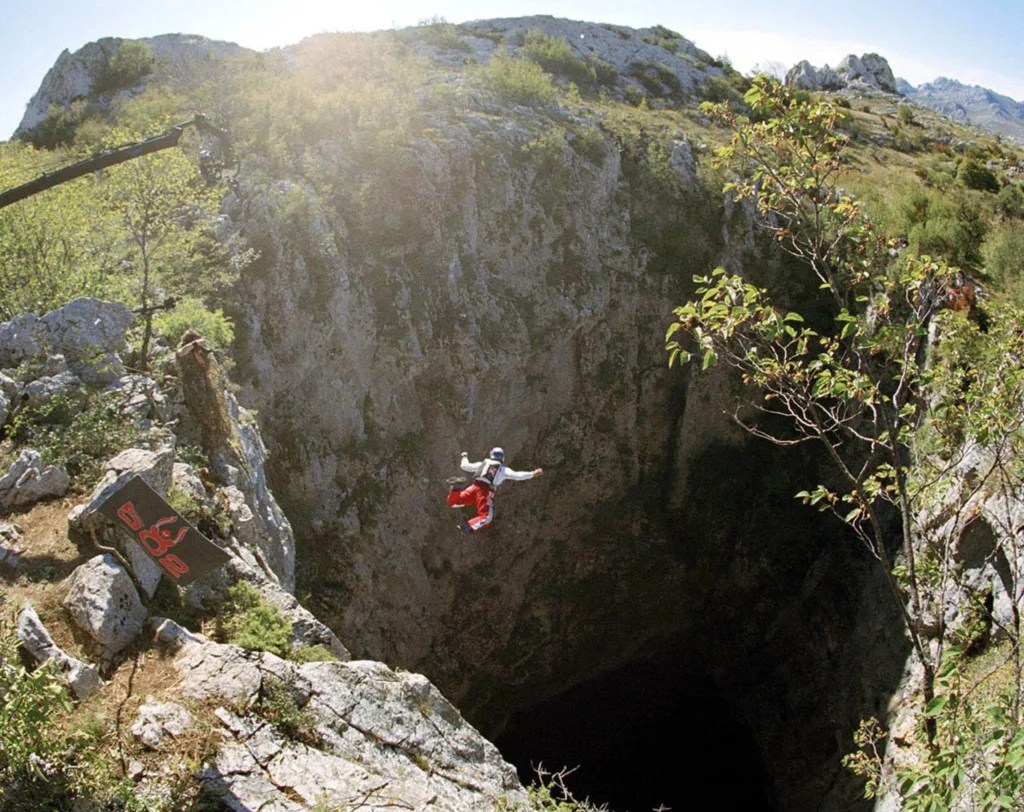
Located in the Huasteca Potosina region of Mexico, the Sotano de las Golondrinas, or “Cave of Swallows,” is a massive sinkhole that stands as one of nature’s most awe-inspiring geological wonders. This enormous natural pit, with its vertical walls plunging to a depth of approximately 370 meters (1,214 feet), is renowned not only for its impressive dimensions but also for the unique ecosystem it harbors and the extreme sports it attracts. The Sotano de las Golondrinas is a testament to the power of geological processes, offering a window into the Earth’s ability to create breathtaking landscapes over millions of years. The formation of this colossal pit is the result of long-term erosion processes in the limestone bedrock characteristic of the region. Over time, acidic rainwater slowly dissolved the limestone, creating an extensive network of underground caverns. Eventually, the ceiling of one of these caverns collapsed, giving birth to the enormous vertical shaft we see today. The sinkhole’s nearly perfect elliptical shape and sheer vertical walls make it a geological marvel, drawing researchers and nature enthusiasts from around the globe. The pit’s name, “Cave of Swallows,” comes from the countless birds that call this unique environment home. However, the name is somewhat of a misnomer, as the majority of the birds inhabiting the cave are actually swifts and green parakeets rather than swallows. These birds have adapted to life in this vertical world, nesting in the crevices and ledges along the sinkhole’s walls. Each morning, tens of thousands of birds emerge from the pit in a spectacular display, spiraling upwards in a vortex-like formation before dispersing to feed. This daily exodus is mirrored in the evening when the birds return, diving into the pit at breathtaking speeds. The sight and sound of these mass bird movements have made the Sotano de las Golondrinas a popular destination for birdwatchers and nature photographers. Beyond its avian inhabitants, the Sotano de las Golondrinas has become a mecca for adventure seekers and extreme sports enthusiasts. The pit’s immense depth and vertical walls make it an ideal location for rappelling and base jumping. Rappelling into the sinkhole is a thrilling experience that attracts climbers from around the world. The descent takes about 20 minutes, while the ascent can take anywhere from 40 minutes to over an hour, depending on the climber’s experience and physical condition. Base jumpers, too, have found a perfect playground in the Sotano de las Golondrinas. The pit’s depth allows for extended free-fall times, making it a coveted location for this extreme sport. However, due to the inherent dangers and the need to protect the sinkhole’s delicate ecosystem, access for these activities is carefully regulated. The Sotano de las Golondrinas also holds significant scientific interest. Its unique environment has led to the evolution of specialized species adapted to life in this vertical world. Researchers have discovered several endemic species of insects and other invertebrates within the pit, highlighting its importance as a biodiversity hotspot. The sinkhole’s depth and structure also provide valuable insights into the geological history of the region, offering clues about past climate conditions and the long-term processes that shape karst landscapes. Despite its remote location, the fame of the Sotano de las Golondrinas has grown in recent years, leading to increased tourism in the area. This has brought both opportunities and challenges to the local communities. While tourism has provided economic benefits, there are ongoing efforts to ensure that visitor activities do not negatively impact the sinkhole’s delicate ecosystem or disturb the birds that call it home. Conservation efforts focus on sustainable tourism practices and educating visitors about the unique geological and ecological significance of the site. In conclusion, the Sotano de las Golondrinas stands as a testament to the raw beauty and power of nature’s geological processes. Its immense scale, unique ecosystem, and the thrilling experiences it offers make it a truly remarkable natural wonder. As research continues and our understanding of this remarkable formation grows, the Cave of Swallows is likely to remain a source of fascination, inspiration, and scientific discovery for generations to come, reminding us of the incredible diversity and beauty of our planet’s geological features.