
7. The Multi-Beam Echo Sounder: 3D Mapping of Underwater Terrain
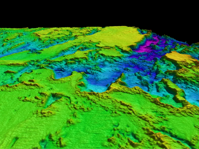
By giving extremely detailed, three-dimensional maps of underwater terrain, the Multi-Beam Echo Sounder (MBES) has transformed underwater reconnaissance. Under a vessel, this complex device releases many sound beams in a fan-like shape using an array of transducers. The MBES can provide a precise bathymetric map of the underwater terrain by timing the bouncing back of these sound waves from the seafloor. The MBES distinguishes itself from conventional sonar systems in that it greatly increases the effectiveness and speed of underwater surveys by allowing a single pass to cover a broad swath of the seaflower. High-resolution 3D models of the seabed can be produced from the resultant data, therefore exposing seamounts, underwater canyons, and even minute items with amazing detail. From shallow coastal waters to the abyssal plains of the deep ocean, modern MBES systems can run at several depths and are hence flexible tools for a broad spectrum of uses. Apart from mapping bathymetry, sophisticated MBES systems can also reveal the composition of the seafloor by means of strength of the returned acoustic waves. Identification of several kinds of sediments, detecting possible resources, and evaluation of marine environments all depend on this capacity. MBES is now a necessary instrument for oceanographic study, offshore energy development, maritime building, nautical charting since its success in underwater reconnaissance. Further increasing our capacity to investigate and comprehend the underwater world as technology develops are MBES systems with sharper resolution, more range, and enhanced data processing capability.